

Latest Weather Blog
Sunday PM Forecast: Overnight Stifling Conditions - Heat Ramps Up Monday
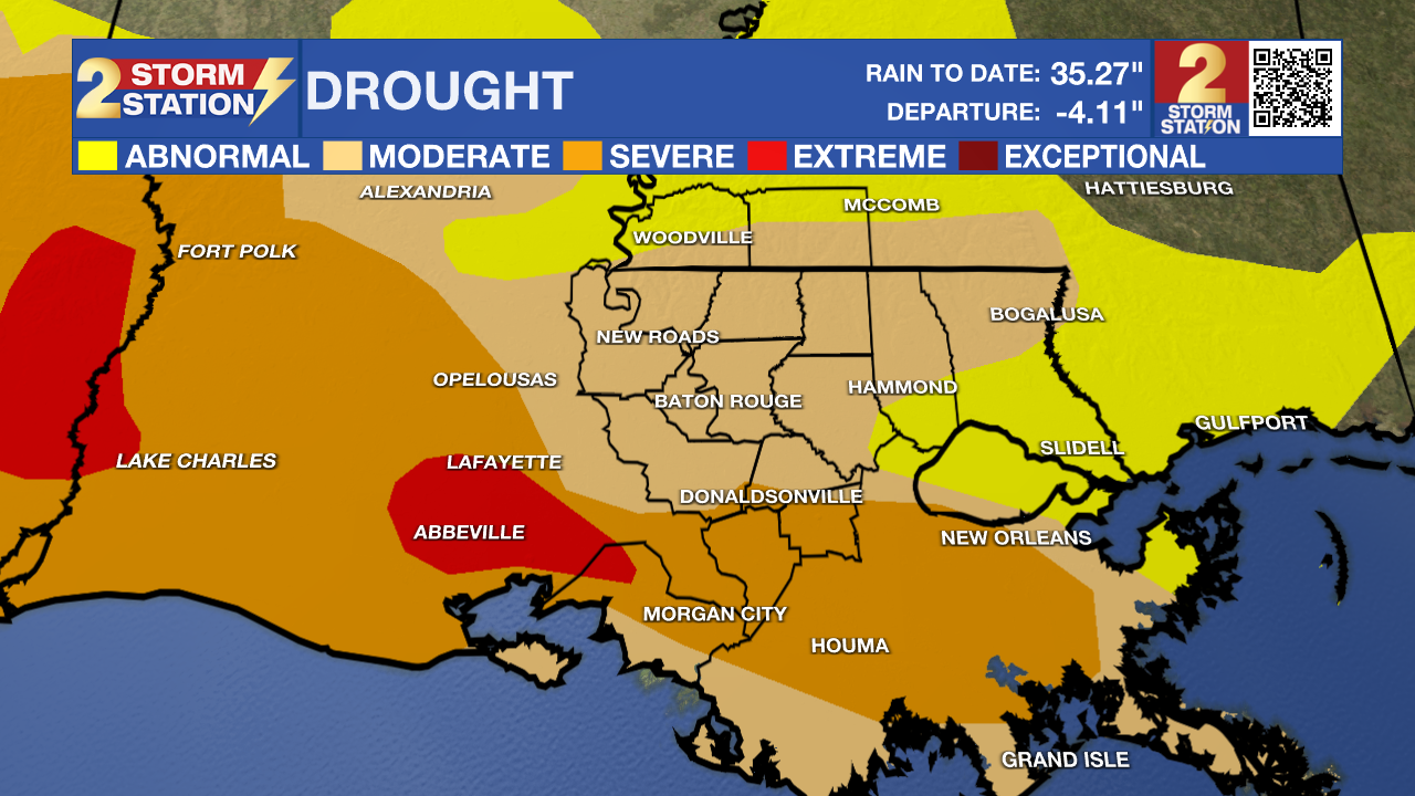
Overnight temps will be at 80-degrees or above once again tonight with no rain in the forecast. Another extremely hot day will be in the works on Monday as drought conditions continue to worsen across the regions. Rain chances are slim for Monday, but some relief could be in sight on Tuesday. The record high temperature for Monday is 102 degrees set back in 2007. Breezy, dry, and hot weather conditions continue through Monday due to a persistent upper-ridge overhead! The weather pattern remains the same through early next week as a trough from the north slides south slightly increasing rain chances and lowering dew points. A break in the 100 degree temperature streak is possible Tuesday or Wednesday. Stay hydrated and check on relatives and neighbors!
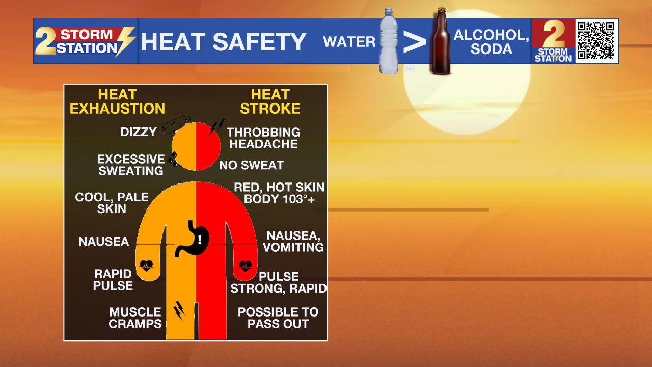
An ***EXCESSIVE HEAT WARNING*** is in effect until 7pm Monday for the entire WBRZ Viewing Area. Dangerously hot conditions with heat index values up to 116 expected. Extreme heat and humidity will significantly increase the potential for heat related illnesses, particularly for those working or participating in outdoor activities. Drink plenty of fluids, stay in an air-conditioned room, stay out of the sun, and check up on relatives and neighbors. Young children and pets should never be left unattended in vehicles under any circumstances. Take extra precautions if you work or spend time outside. When possible reschedule strenuous activities to early morning or evening. Know the signs and symptoms of heat exhaustion and heat stroke. Wear lightweight and loose fitting clothing when possible. To reduce risk during outdoor work, the Occupational Safety and Health Administration recommends scheduling frequent rest breaks in shaded or air conditioned environments. Anyone overcome by heat should be moved to a cool and shaded location.
REVIEW HEAT SAFETY AND KNOW THE SYMPTOMS OF HEAT EXHAUSTION VERSUS HEAT STROKE
Up Next: As high pressure is centered over Texas, another day of excessive heat is expected across the region on Monday. Highs will be in the 102-103 degree range later in the afternoon with heat index values of at least 113 degrees. With the sinking air from the high pressure, rain chances appear negligible on Monday
The next workweek will start off hot, with highs of 102-103 both Monday and Tuesday. Later in the day on Tuesday, however, a front will move through the area. This will increase clouds and give us a chance of showers Tuesday afternoon and Tuesday night. Hopefully, this front can bring us some much-needed rainfall, but rain chances look isolated-to-scattered (30-40%) at best.
Trending News
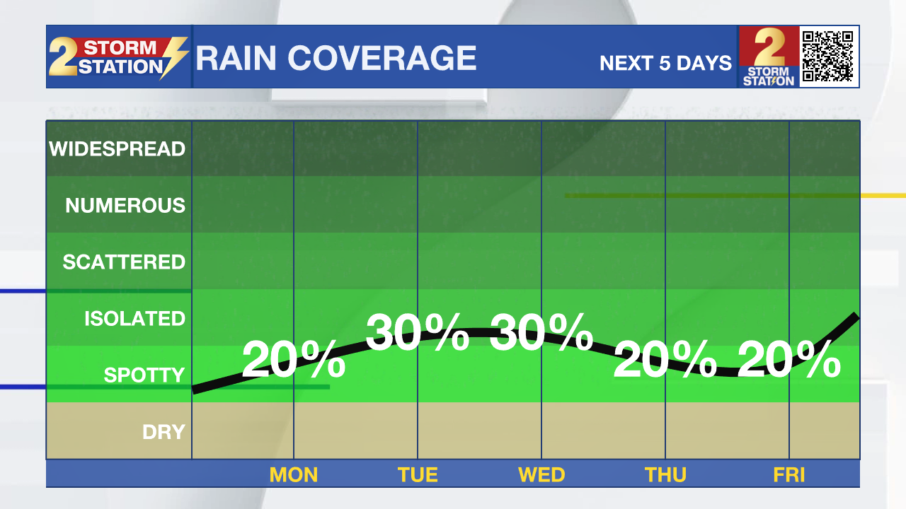
This front will bring a dose of drier air into the area by Wednesday and Thursday. It won’t do much to curb the heat, but with drier air comes lower dew points, which means lower heat index values. Also, we could see more comfortable temperatures Wednesday and Thursday mornings, with lows dipping down into the mid-70s.
The ridge of high pressure looks to build back in by the end of the week and the weekend, resuming triple-digit readings.
Get the latest 7-day forecast and real time weather updates HERE.
Watch live news HERE.
The Tropics: Tropical cyclone activity is not expected in the next 7 days.
--Keller
The Storm Station is here for you, on every platform. Your weather updates can be found on News 2, wbrz.com, and the WBRZ WX App on your Apple or Android device. Follow WBRZ Weather on Facebook and Twitter for even more weather updates while you are on the go.
More News
