

Latest Weather Blog
Wednesday PM Forecast: 11th consecutive HEAT ADVISORY in effect on Thursday
A *HEAT ADVISORY* will be in effect from 10am to 7pm Thursday for the 11th consecutive day as feels-like temperatures top out at or above 108° across the entire Storm Station Forecast Area. Hot temperatures and high humidity may cause heat illnesses. Be on the lookout for signs of heat exhaustion and heat stroke, drink plenty of fluids, take frequent breaks, and check up on relatives and neighbors.
Tonight & Tomorrow: Expect another clear night with overnight lows in the upper 70s to near 80 degrees. Thursday will continue to bring on the heat. High temperatures will flirting with the century mark in Baton Rouge. Outside of the city, temperatures will be a touch cooler. But even there, temperatures still manage to reach the middle and upper 90s. With several school districts opening doors on Thursday, kids will face plenty of heat on the way home. Hydration will be key for any outdoor after school activities.
With the humidity taken into account, peak feels-like temperatures should eclipse 108° which meets Heat Advisory criteria. After a sunny start, fair weather cumulus clouds will pop-up during the afternoon.
Up Next: The hot and dry pattern doesn't let up for the remainder of the week. More heat alerts are likely. Afternoon highs continue to flirt with 100° all the way through Friday. In doing so, 2024 could end up as one of the hottest summers on record and, specifically, crack the top three for most 100° days in a year.
While humidity might back off slightly this weekend, it will not be by much. The minor relief would come via a weak front on Sunday, but that's far from a guarantee. The latest data show the front stalling to our north, keeping us relatively hot and humid. Rain is also scarce on the Storm Station 7-Day Forecast, with few seeing any meaningful rain.
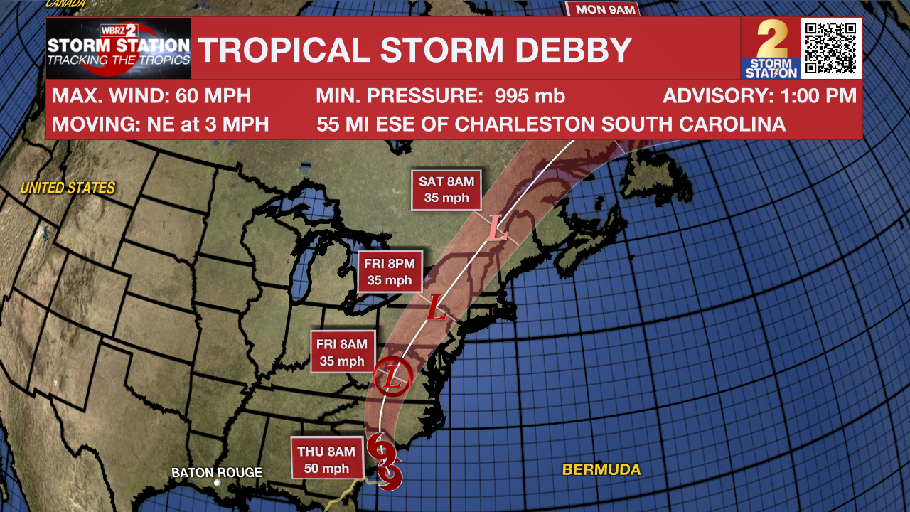
The Tropics: After moving offshore, Tropical Storm Debby's peak winds have slowly increased. The system was moving at a slow rate of 3 mph on Wednesday, continuing to dump heavy rain over the Carolinas. Rainfall could be historic in the region with totals of 15 to 25 inches in parts of the Carolinas, producing catastrophic flooding. Debby will eventually make a second landfall in South Carolina sometime late in the day on Wednesday, or Wednesday night. The storm will move into North Carolina on Thursday before pulling away on Friday.
Trending News
The National Hurricane Center has been tracking a tropical wave located over the southwestern Caribbean Sea. The wave remains disorganized. The disturbance will move westward and inland over Central America during the next day or two. Per the latest data, tropical development of this system is not expected.
Get the latest 7-day forecast and real time weather updates HERE.
Watch live news HERE.
-- Meteorologist Malcolm Byron
The Storm Station is here for you, on every platform. Your weather updates can be found on News 2, wbrz.com, and the WBRZ WX App on your Apple or Android device. Follow WBRZ Weather on Facebook and Twitter for even more weather updates while you are on the go.
More News
