NEW: Francine continues to strengthen, likely to become a hurricane Tuesday
Clouds and rain coverage increase on Tuesday as tropical moisture returns to the region. The weather deteriorates thereafter as what soon could be Hurricane Francine approaches the Louisiana coast. Pay close attention to the forecast leading up to landfall, any last minute hurricane preparations need to be completed by Tuesday night.
Scroll farther down the page to find the short-term forecast.
The Latest On Francine: As of 4 a.m. Tuesday, Tropical Storm Francine maintains peak winds at 65 mph. Strengthening of the system is expected on Tuesday. Francine will likely become a hurricane by Tuesday afternoon. There is indication that over the warm gulf waters, Francine could strengthen to a category two storm by Wednesday before the system makes landfall over the Louisiana coast.
The latest forecast calls for a landfall in southwest or south-central Louisiana on Wednesday afternoon with peak winds near 100 mph. Francine will quickly weaken thereafter and pull away from the region on Thursday. Pay close attention to the forecast leading up to landfall, review your hurricane preparedness plan, and refresh supplies if needed. Hurricane preparations need to be completed by Tuesday night.
Understand that adjustments may be needed in the coming days as new data arrives. Keep up to date with the latest forecast. The Storm Station has you covered on-air, online, and on social media. Download the free, WBRZ weather app HERE to find out first when new tropical updates become available.
Trending News

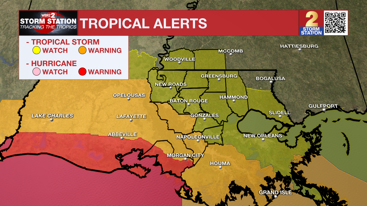
A ***HURRICANE WARNING*** is in effect through Thursday morning along the Louisiana coast from Sabine Pass to Morgan City. Expect sustained winds in the ballpark of 75-95 mph with gusts over 100 mph for our covered parishes in this region. Changes in strength are possible as new data arrives.
A ***TROPICAL STORM WARNING*** is in effect through Thursday morning for Assumption, Iberville and northern St. Mary Parishes. Expect sustained winds between 40-70 mph with gusts over 75 mph for these areas. Changes in strength are possible as new data arrives.
A ***TROPICAL STORM WATCH*** is in effect through Thursday morning for East Baton Rouge, West Baton Rouge, Livingston, Ascension, St. James, Tangipahoa, Pointe Coupee, West Feliciana, East Feliciana and St. Helena Parishes as well as Wilkinson and Amite Counties. Prepare for tropical storm-force winds between 39 and 73 mph. Hurricane-force wind gusts may be possible at times, especially closer to Baton Rouge with the latest trajectory. Changes in strength are possible as new data arrives.

Impacts will begin across southern Louisiana as early as Wednesday, lasting through Wednesday night and into early Thursday.
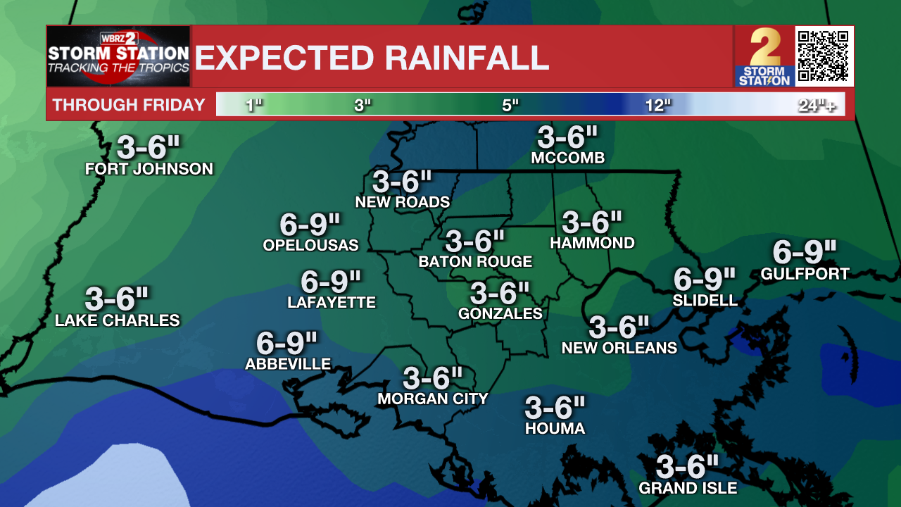
Heavy Rain/Flooding: 3-6" of rain is possible in Metro Baton Rouge, with higher amounts perhaps in the ballpark of 8"+ closer to where the center of the system tracks. Typical trouble spots may hold water, and southeast-facing shores will face minor to moderate coastal flooding.

A ***FLOOD WATCH*** has been issued for the entirety of south Louisiana. Excessive runoff may result in flooding of rivers, creeks, streams, and other low-lying and flood-prone locations. A Flood Watch means conditions may develop that lead to flash flooding. Flash flooding is a very dangerous situation. Be on the lookout for threatening weather conditions and listen for later statements and possible warnings. For more on flooding safety, CLICK HERE.
Tornadoes: The latest trajectory places the capital area on the right, forward side of the storm. It is this part where tornadoes are often found. Tropical tornadoes tend to develop quickly and be short-lived. Have a way to receive alerts and be alert to Tornado Warnings beginning Wednesday. For more on tornado safety, CLICK HERE.
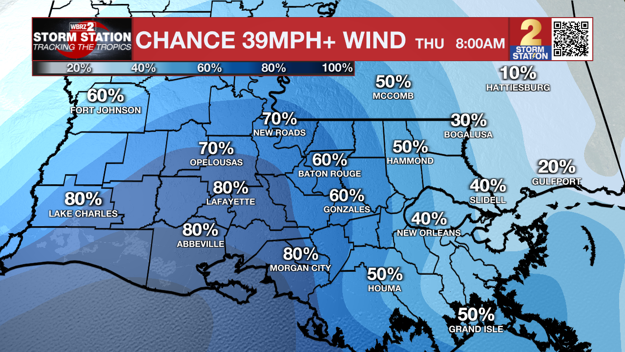
Wind: Guidance has trended toward a slightly stronger storm upon landfall, likely as a Category 2 hurricane. The wind forecast will ultimately hinge on one’s proximity to the system. Those who end up near the center of circulation could experience hurricane-force winds, especially for those closer to the coast. Farther inland and away from the center, tropical storm-force winds are possible with higher hurricane-force gusts. Winds will ramp up on Wednesday, peak Wednesday night, before subsiding on Thursday.

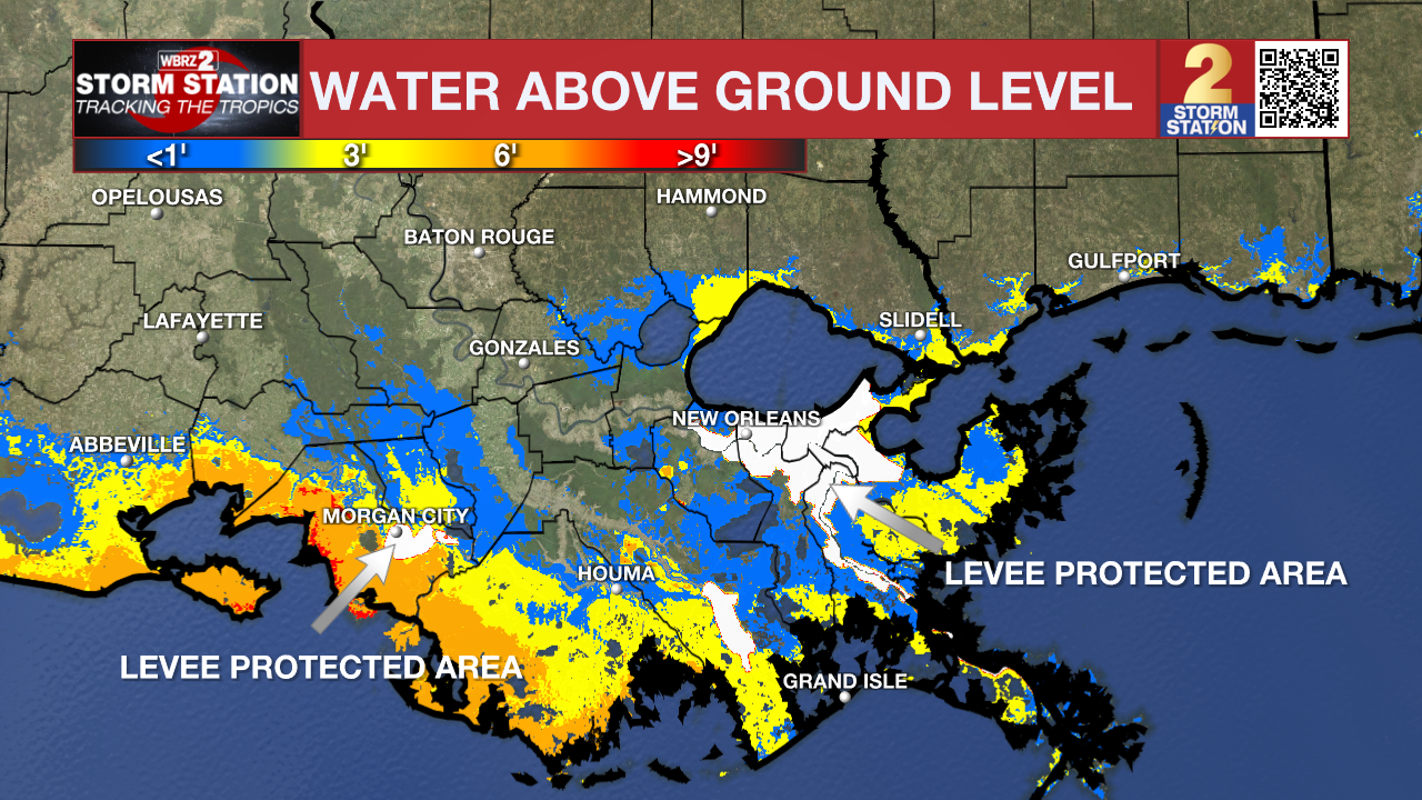
Storm Surge: Winds associated with Francine will push water toward the immediate coastline. Anywhere from 5 to 10 feet of storm surge is possible along the coast. 2 to 4 feet of surge is possible along the Northshore. This is primarily an issue for non-levee protected areas.

A ***STORM SURGE WARNING*** is in effect along the immediate coastline through Thursday.
A ***STORM SURGE WATCH*** is in effect for the Northshore.
This is a life-threatening situation for areas affected. Evacuation efforts and flood preparations should soon be brought to completion before conditions become unsafe. Be on the lookout for evacuation orders from officials and leave immediately if ordered.
The following is the short-term forecast prior to any potential tropical impacts by midweek.
Tuesday: Clouds will increase on Tuesday as moisture content improves. During the day, numerous showers and thunderstorms will begin to arrive from the south. Highs will be slightly cooler as a result, likely sitting in the low to mid-80s. Rain coverage will increase late Tuesday and into Wednesday as Francine draws closer.
After Francine: Conditions will dramatically improve on Thursday. There may be some lingering breezes and isolated showers in the wake of Francine, but the day will otherwise feature a mix of sun and clouds with humidity and highs in the mid 80s. Ample sunshine and dry conditions will stick around Friday through the weekend but it will feel much like late summer with highs in the upper 80s, lows in the low 70s and some mugginess. CLICK HERE for the full Storm Station 7-Day Forecast.
The Storm Station is here for you, tracking the tropics on every platform. Your weather updates can be found on News 2, wbrz.com, and the WBRZ WX App on your Apple or Android device. Follow WBRZ Weather on Facebook and Twitter for even more weather updates while you are on the go. You can also find tropical updates on our Hurricane Center HERE.


