

Latest Weather Blog
Saturday PM Forecast: Short humidity break Sunday, watching the tropics next week
After a prolonged stretch of dreary weather, the capital area will reap the benefits of a cold front passage on Sunday. The gorgeous weather left behind will be short-lived, however. Rain soon returns in the Storm Station 7-Day Forecast.
Tonight & Tomorrow: The much anticipated cold front will finally pass through on Saturday night. Skies will clear out and the humidity will drop. Although evening temperatures only dip into the mid-70s, overnight lows will bottom out in the mid-60s in response to falling humidity. Sunday will be a beautiful day. Aside from a passing high cloud or two, skies will be mainly sunny. Daytime highs will be a few degrees below average for early September, in the mid to upper-80s. Make an excuse to get outside and enjoy this taste of fall - it should also serve as a great day to mow.
Up Next: Unfortunately, the taste of fall will be short-lived. Humidity quickly climbs on Monday, but air temperatures hardly budge. Look for a high in the upper-80s on Monday with a slim shot at rain. Rain is set to make a return beginning on Tuesday as bountiful Gulf moisture takes aim at the area yet again. Heavy rain looks to be a possibility again, especially as rain coverage maximizes on Wednesday and Thursday. 1-4" appears possible across southeast Louisiana through the next week, but locally higher amounts are not out of the question. Flood headlines might be needed later on in the week.
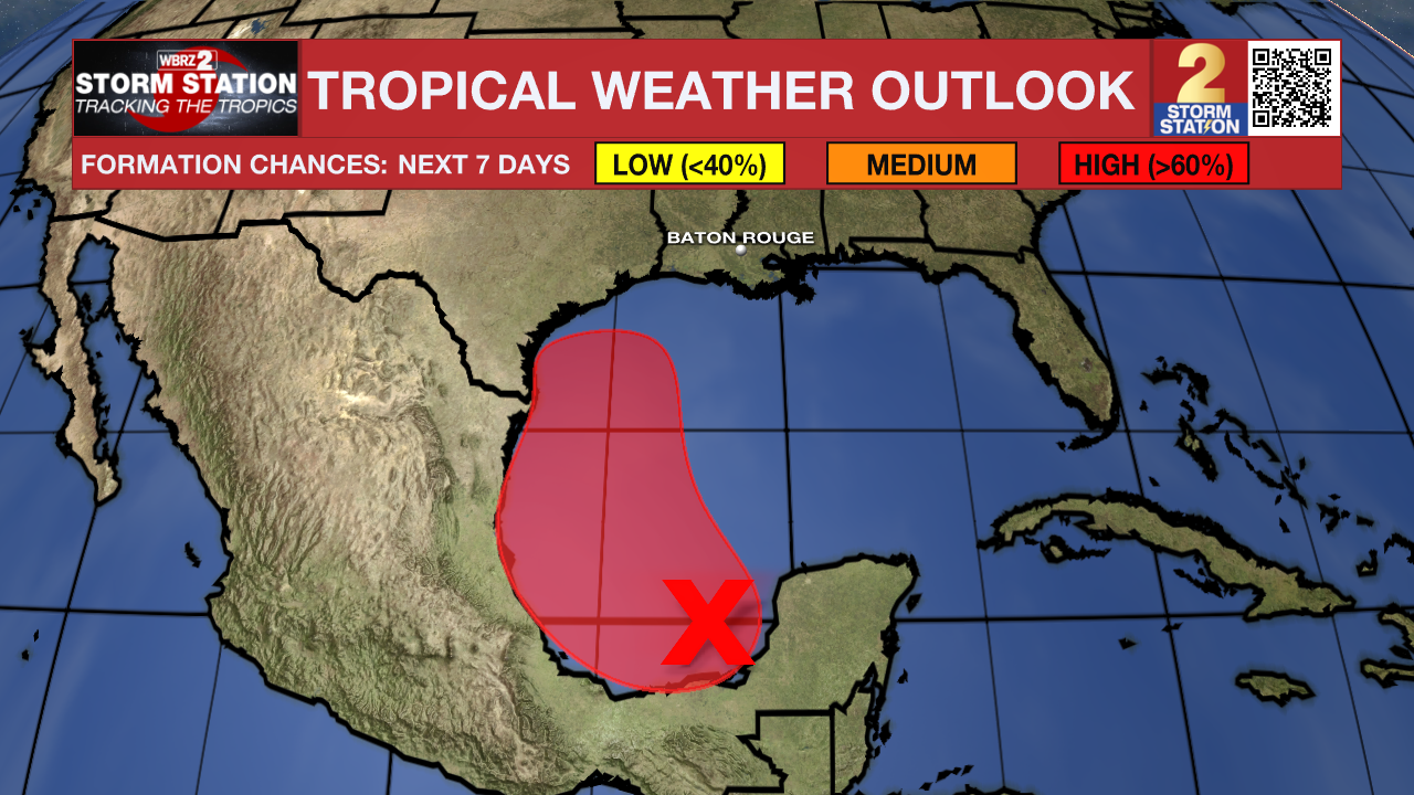
There is a tropical connection to this activity as well. A disturbance in the southwest Gulf of Mexico will move north into next week, perhaps becoming the next tropical depression or storm. Computer model guidance now takes the system into east Texas or southwest Louisiana, leaving the capital region on the wet side of the system as it slingshots Gulf moisture toward the area. All things considered, it is not known at this time whether southeast Louisiana will experience direct or indirect impacts. A eastward track would promote direct impacts, with a more westward tracking favoring indirect impacts. The overall system track will be difficult to pinpoint until a system actually develops. That probably won't occur for at least a few more days. This is a system to pay attention to, and fortunately there is still some time to watch things.
The Tropics: An area of low pressure has formed over the Bay of Campeche and is now disorganized. The system will slowly drift northward for a couple of days while it interacts with a front. Into next week, conditions will become more favorable for development. A tropical depression is likely to form during the early or middle part of the week while moving near or along the Mexican and Texas Gulf coastline. This is a system to monitor closely (see above).
Another area of low pressure is located over the central tropical Atlantic, and may gradually organize over the next couple of days. The disturbance has about a 50% chance of becoming a tropical depression early next week. No local impacts are expected from this system in the near future.
Trending News
A third region of disorganized thunderstorm activity is located several hundred miles east-southeast of the Cabo Verde Islands. Slow development of this system is possible as it interacts with a tropical wave expected to move off the coast of Africa early next week. For now, this system has medium chances of development in the next week.
Get the latest 7-day forecast and real time weather updates HERE.
Watch live news HERE.
-- Meteorologist Malcolm Byron
The Storm Station is here for you, on every platform. Your weather updates can be found on News 2, wbrz.com, and the WBRZ WX App on your Apple or Android device. Follow WBRZ Weather on Facebook and Twitter for even more weather updates while you are on the go
More News
