

Latest Weather Blog
Threat for heavy rain decreasing into busy weekend of football in Capital Area
The threat for showers, thunderstorms and even isolated flooding remains through the night. Over the weekend, a drier and more comfortable air mass will slowly move into the region for a brief period.
The National Weather Service will maintain a FLOOD WATCH for all parishes along and south of I-10/12, including the city of Baton Rouge, through Saturday morning. While you should monitor later forecasts and be alert to possible warnings, the threat for heavy rain will continue diminishing quickly into the evening hours. Report any observed flooding to the Storm Station via weather@wbrz.com or local emergency services when you can do so safely.
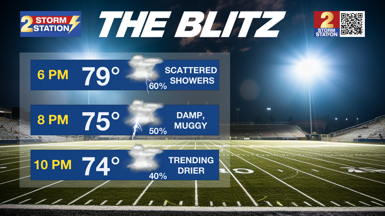
Friday Night: With rain continuing into Friday night, it is advised to plan accordingly and bring necessary raingear to all outdoor events, including high school football games. Scattered showers will bounce around the Capital Region throughout the evening, although they should be lighter in nature and not constant. When not actively raining, it will still feel damp and muggy. Temperatures will ease down through the mid to low 70s.
Saturday: A front will slowly pass through the state during the day Saturday. The slow moving nature of this front will result in very gradual changes. Cloud cover will be slow to break, but should do so from north to south into the afternoon. Especially along and north of I-10/12, a bit of sun is expected before nightfall. For areas along and south of I-10/12, a few showers could continue throughout the day until the front completely passes through. In fact, a spotty shower can not even be eliminated as a possibility for the Metro Area and north as the front passes through during the late afternoon and evening hours. If you are heading out to the LSU or Southern games or simply tailgating, the majority of the day will be dry but it would be a good idea to take a poncho even if it may only needed for a brief time. Temperatures will move slowly through the 70s as clouds linger but will quickly warm into the the mid to upper 80s as some sun shines through.
Trending News
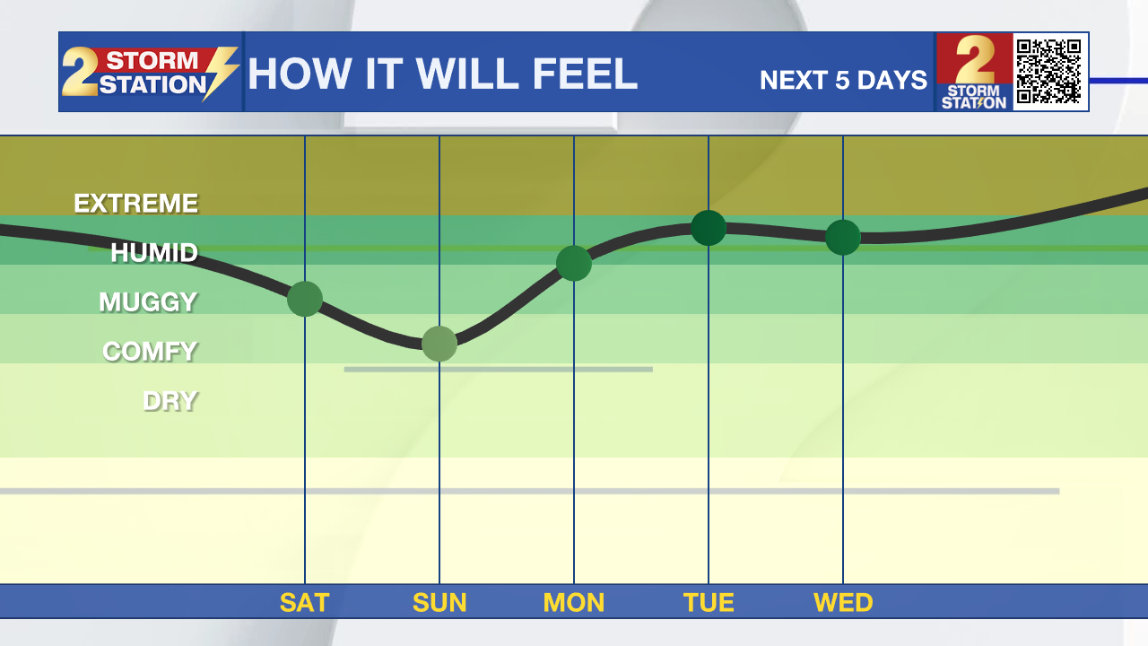
Up Next: A reinforcing shot of dry air on Sunday morning is likely to bring a much more comfortable air mass. Morning lows Sunday and Monday will dip below average for early September, into the mid 60s. Afternoons highs will also be comfortable in the upper 80s with low humidity. Rain will make a prompt return by Tuesday and into the middle of next week as another bountiful amount of gulf moisture is set to arrive to the area.
Get the latest 7-day forecast and real time weather updates HERE.
Watch live news HERE.
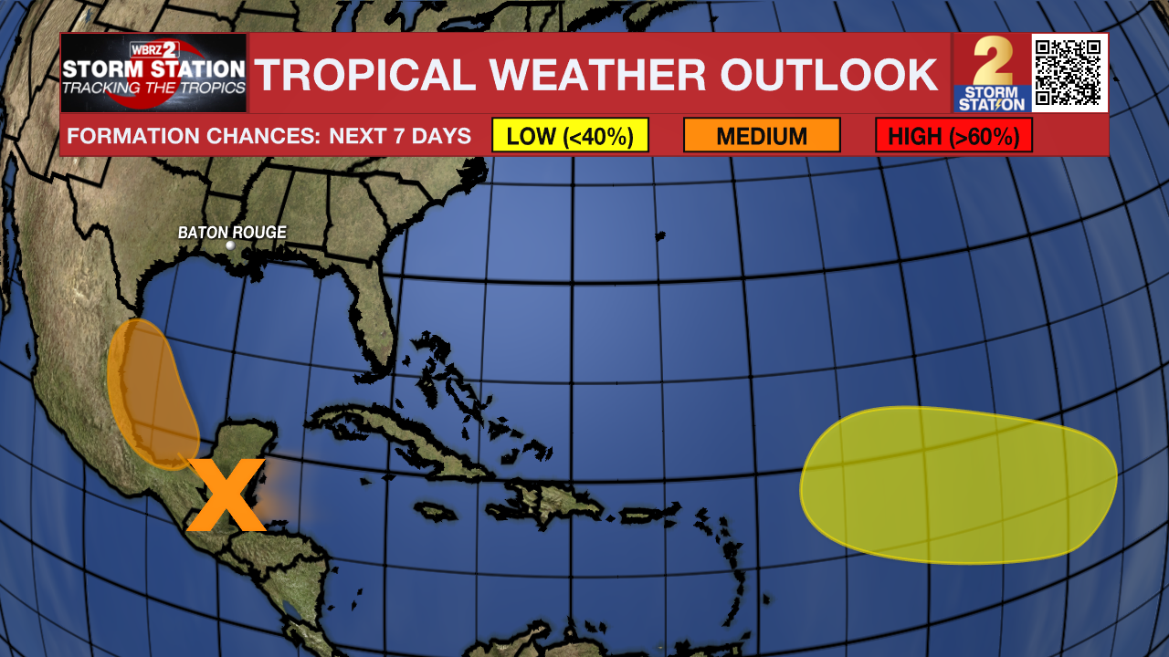
The Tropics: A tropical wave located over Belize and the Yucatan Peninsula of Mexico is producing disorganized showers and thunderstorms. The wave is forecast to move into the Bay of Campeche on Saturday, where it could then begin to interact with a frontal boundary. A tropical depression could form during the early or middle part of next week while the system moves slowly northwestward over the southwestern Gulf of Mexico.
An elongated trough of low pressure over the eastern tropical Atlantic is producing minimal shower and thunderstorm activity. Development, if any, should be slow to occur while the disturbance meanders through the early part of next week and then begins to move west-northwestward across the central tropical Atlantic during the middle to latter part of next week.
The Storm Station is here for you, on every platform. Your weather updates can be found on News 2, wbrz.com, and the WBRZ WX App on your Apple or Android device. Follow WBRZ Weather on Facebook and Twitter for even more weather updates while you are on the go.
More News
