

Latest Weather Blog
Sunday AM Forecast: pleasant conditions Sunday, eyes on the tropics
A cold front has moved through the area, and that means way less humidity and cloud cover on Sunday. The tropics are heating up, and an invest in the Gulf of Mexico will need to be watched closely over the next several days.
Today & Tonight: The much anticipated cold front has finally passed through the area. While this made our morning temperatures feel very nice, highs will still get into the upper 80's because of abundant sunshine. The piece of good news is that humidity will be much lower than the last several days. Overall, today is the perfect day to get outside and enjoy the weather. Tonight, skies will be mostly clear, and lows will be in the middle 60's.
Up Next: Unfortunately, the taste of fall will be short-lived. Humidity quickly climbs on Monday, but air temperatures hardly budge. Highs will be in the upper 80's, with only slight rain chances. Rain is set to make a return beginning on Tuesday as bountiful Gulf moisture takes aim at the area yet again. Heavy rain looks to be a possibility, especially as rain coverage maximizes on Wednesday and Thursday. 1-4" appears possible across southeast Louisiana through the next week, but locally higher amounts are not out of the question.
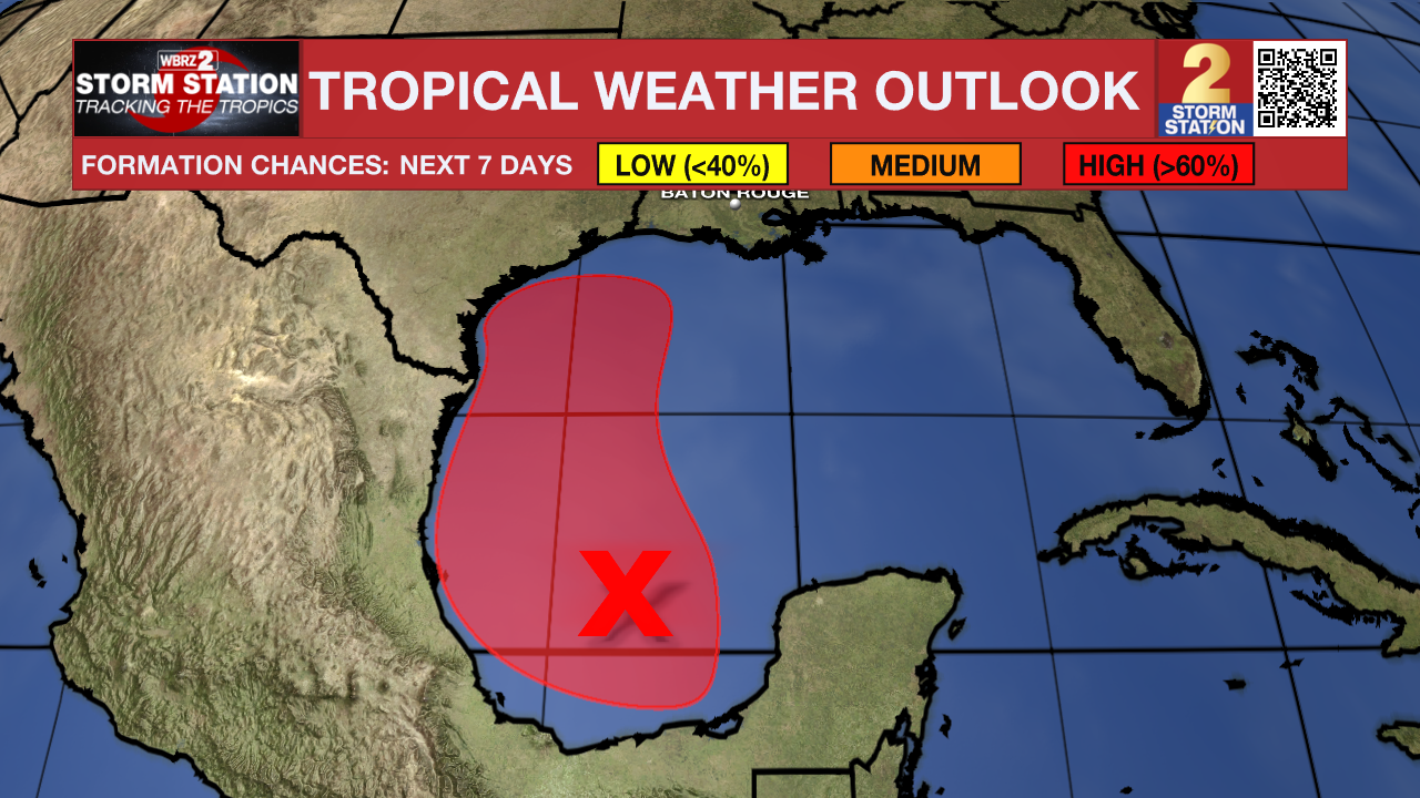
There is a tropical connection to this activity as well. A disturbance in the southwest Gulf of Mexico will move north into next week, perhaps becoming the next tropical depression or storm. Model guidance now takes the system into east Texas or southwest Louisiana, leaving the capital region on the wet side of the system as it slingshots Gulf moisture toward the area. All things considered, it is not known at this time whether southeast Louisiana will experience direct or indirect impacts. A eastward track would promote direct impacts, with a more westward tracking favoring indirect impacts. The overall system track will be difficult to pinpoint until a system actually develops. That probably won't occur for at least a few more days. This is a system to pay attention to, and fortunately there is still some time to watch things.
The Tropics: Showers and thunderstorms have increased this morning in association with a broad area of low pressure located over the southwestern Gulf of Mexico. This system is forecast to drift slowly northwestward during the next couple of days, and environmental conditions are expected to become conducive for additional development. A tropical depression is likely to form during the next couple of days as the system moves generally northwestward and then northward near or along the Gulf coast of Mexico and Texas through the middle of the week. Interests along the western and northwestern Gulf Coast should closely monitor the progress of this system. Watches could be required for portions of the western Gulf coast later today or tonight. An Air-Force Reserve Hurricane Hunter aircraft is also scheduled to investigate the system later today. This is a system to monitor closely (see above).
Trending News
Showers and thunderstorms associated with an elongated area of low pressure over the central tropical Atlantic continue to show some signs of organization. Environmental conditions appear conducive for additional development of this system, and a tropical depression could form while the system meanders over the central tropical Atlantic through Monday and then begins to move generally westward at around 10 mph through the rest of the week.
A trough of low pressure located several hundred miles southwest of the Cabo Verde Islands is producing a broad area of disorganized showers and thunderstorms. This system is expected to move very little during the next couple of days until it potentially interacts with a tropical wave that is forecast to move off the west coast of Africa on Monday. Environmental conditions thereafter are expected to be favorable for gradual development of this system, and a tropical depression could form by the middle or latter part of the week while the system begins moving slowly west-northwestward.
Get the latest 7-day forecast and real time weather updates HERE.
Watch live news HERE.
-- Balin
The Storm Station is here for you, on every platform. Your weather updates can be found on News 2, wbrz.com, and the WBRZ WX App on your Apple or Android device. Follow WBRZ Weather on Facebook and Twitter for even more weather updates while you are on the go
More News
