

Latest Weather Blog
Friday AM Forecast: more storms today, less coverage over the weekend
Moisture will stay high across the area, leading to scattered showers and thunderstorms. This moisture will get slightly lower over the weekend, leading to storms being spotty to isolated in nature.
A * HEAT ADVISORY* is in effect from 10am to 7pm Friday for all of southeast Louisiana and southwest Mississippi, as feels-like temperatures up to 112 degrees are expected. Hot temperatures will combine with moderate humidity and could possibly cause heat illnesses. Drink plenty of fluids, and when possible, stay in an air-conditioned rooms, avoid afternoon sun, and check up on relatives and neighbors.
Today & Tonight: Another active day of storms are expected. About 60% of the 13 parish, 2 county viewing area will pick up measurable rainfall. These storms will be capable of heavy rain, frequent lightning, and gusty winds. Before the storms, it will be hot. Highs will be near 98 degrees, with high humidity making it feel up to 112 degrees. Skies will start off mostly sunny, with skies turning mostly cloudy in the afternoon and evening. Showers and storms will quickly dissipate after the sun sets. This will lead to a mostly clear night, with lows near 79 degrees.
Up Next: Moisture will begin to decrease over the weekend. This will scale back the coverage to spotty or isolated. A weak front will approach, and move through the area on Monday. While this may initially bring a few storms, drier air will filter in behind the front. This will lead to mainly dry conditions, and much lower humidity through the middle of the week. We will also be able to get low temperatures back to average in the low 70s. On the other hand, since drier air warms up more efficiently than humid air, we will keep high temperatures rather hot. The heat index may just be a tad more muted than previous days.
Trending News
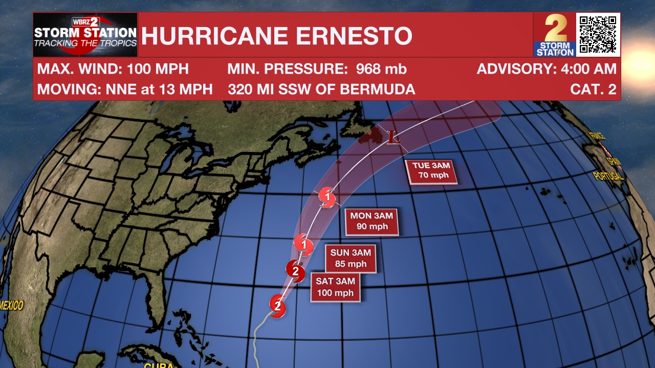
The Tropics: Hurricane Ernesto is continuing to strengthen over the Atlantic Ocean, prompting a hurricane warning for Bermuda. As of 5am Friday, Ernesto had maximum sustained winds of 100mph and was moving NNE at 13mph. Ernesto will continue north or northeast on Friday at a slightly slower forward speed while getting larger strengthening toward major hurricane status. The storm will be close to Bermuda this weekend.
Get the latest 7-day forecast and real time weather updates HERE.
Watch live news HERE.
– Balin
The Storm Station is here for you, on every platform. Your weather updates can be found on News 2, wbrz.com, and the WBRZ WX App on your Apple or Android device. Follow WBRZ Weather on Facebook and Twitter for even more weather updates while you are on the go.
More News
