

Latest Weather Blog
Friday PM Forecast: Heat Alerts continue into the weekend, Rain coverage declines
Despite a few isolated storms over the weekend, conditions will be mostly dry, partly sunny, and hot. A weak front early next week will bring a push of drier air, taking humidity levels down a bit for the week.
A *HEAT ADVISORY* is in effect from 10am to 7pm Saturday for all of southeast Louisiana and southwest Mississippi, as feels-like temperatures up to 112 degrees are expected. Hot temperatures will combine with moderate humidity and could possibly cause heat illnesses. Drink plenty of fluids, and when possible, stay in an air-conditioned rooms, avoid afternoon sun, and check up on relatives and neighbors.
Tonight & Tomorrow: Any lingering storm activity will begin to dissipate by nightfall Friday, with clearing skies throughout the night. Saturday morning will see temperatures around the region in the middle to upper-70's before sunrise. Once the sun is up, temperatures will quickly climb, nearing the lower 90's by mid morning and into the upper-90's by early afternoon. Baton Rouge will see a high temperature near 97° Saturday with mostly to partly sunny skies. Besides a quick isolated storm Saturday afternoon, conditions will be mainly dry throughout the day.
Up Next: While temperatures Sunday will be very similar to Saturday, lows in the 70's and highs well into the 90s, slightly drier air will limit storm chances Sunday afternoon. One or two showers may be spotted but the majority of the region will stay dry. Early next week, a frontal system will approach the region. Ahead of the front, a surge of moisture may bring a quick round of isolated thunderstorms on Monday, but once the front passes through Monday night, drier air will filter into the state. The dry air will shut off rain chances through the middle of the week and take humidity levels down a touch as well. Unfortunately, the front won't have much effect on our hot afternoon temperatures, but it will allow morning lows to sink back near average, into the lower-70's, each morning.
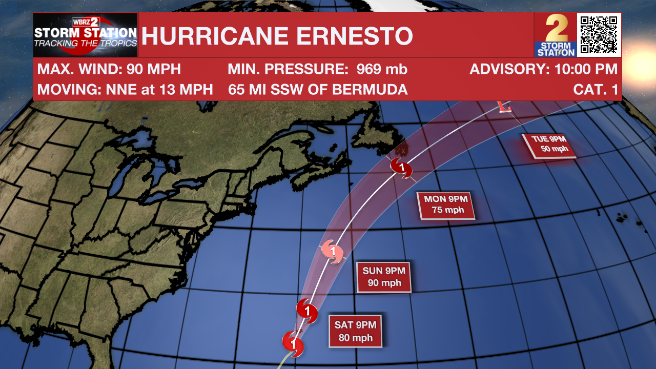
The Tropics: Hurricane Ernesto will make landfall late Friday night in Bermuda, bringing Category 2 strength damaging winds, storm surges, and flooding to the island. Ernesto will then continue north/northeast over the weekend and into early next week as the storm slowly loses speed and strength when entering the cooler waters of the northern Atlantic.
Trending News
Get the latest 7-day forecast and real time weather updates HERE.
Watch live news HERE.
– Emma Kate C.
The Storm Station is here for you, on every platform. Your weather updates can be found on News 2, wbrz.com, and the WBRZ WX App on your Apple or Android device. Follow WBRZ Weather on Facebook and Twitter for even more weather updates while you are on the go.
More News
