

Latest Weather Blog
NEW: significant increase in rain chances for Thursday, Friday
If you have been missing out on the spotty, afternoon showers and thunderstorms then you might like a fairly substantial change to the forecast for the rest of the workweek. A pocket of tropical moisture is expected to move over the Gulf Coast and provide an uptick in precipitation.
A * HEAT ADVISORY* is in effect from 10am to 7pm Thursday for areas south of the Mississippi State Line, as feels-like temperatures over 108 degrees are expected. Hot temperatures will combine with moderate humidity and could possibly cause heat illnesses. Drink plenty of fluids, and when possible, stay in an air-conditioned rooms, avoid afternoon sun, and check up on relatives and neighbors.
Tonight & Tomorrow: Soupy air will keep low temperatures near 80 degrees overnight. Any remnant showers will quickly diminish to a mostly clear sky. It appears a lot more moisture will be in the atmosphere on Thursday than previously expected. As a result, after high temperatures top out near 98 degrees by early afternoon, scattered showers and thunderstorms are expected to develop. Some of the thunderstorms could even produce gusty wind. Upwards of 60 percent of the Metro Area should receive rain and even associated clouds will help limit the duration of dangerous feels-like temperatures.
Up Next: Similarly, on Friday there will be enough moisture in the region to squeeze out scattered showers and thunderstorms. That moisture will slowly dry up Saturday and especially Sunday and beyond. In fact, a weak front will push through the Metro Area causing a minor dip in humidity and low temperatures as well. On the other hand, high temperatures are likely to remain rather hot since drier air warms up more efficiently than humid air. The heat index may just be a tad more muted than previous days.
Trending News
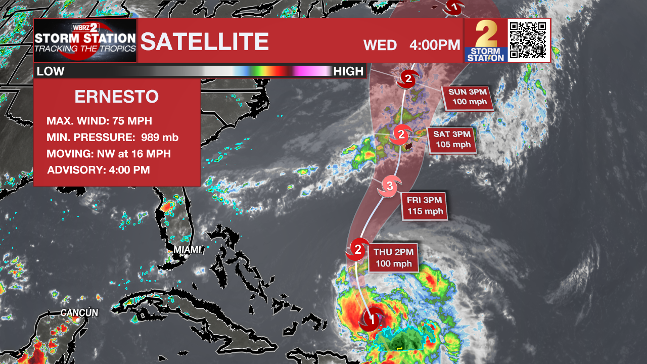
The Tropics: Hurricane Ernesto is expected to steadily strengthen over the Atlantic Ocean, prompting a hurricane watch for Bermuda. As of 4pm Wednesday, Ernesto had maximum sustained winds of 75mph and was moving northwest at 16mph. Ernesto will begin to move more due north on Thursday while strengthening toward major hurricane status by Friday. The storm will be close to Bermuda this weekend.
Get the latest 7-day forecast and real time weather updates HERE.
Watch live news HERE.
– Josh
The Storm Station is here for you, on every platform. Your weather updates can be found on News 2, wbrz.com, and the WBRZ WX App on your Apple or Android device. Follow WBRZ Weather on Facebook and Twitter for even more weather updates while you are on the go.
More News
