

Latest Weather Blog
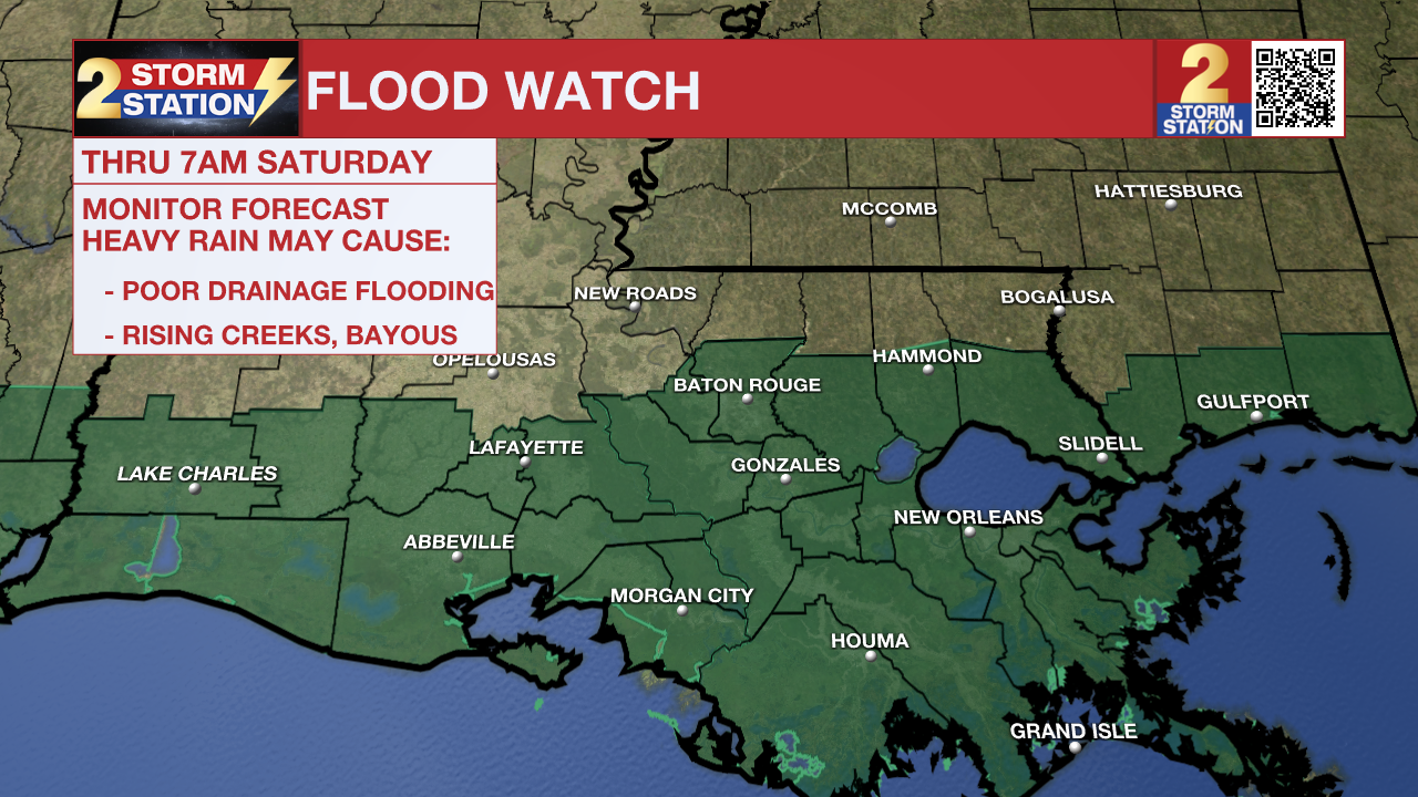
FLOOD WATCH in effect through Saturday as widespread rain continues to arrive
The threat for heavy rain and flash flooding remains ON Thursday and Friday as widespread showers and storms continue to push in from the Gulf. Keep raingear nearby and stay weather-aware through the weekend.
1 p.m. Thursday: The heavy rain band which passed through metro Baton Rouge in the last several hours continues to slowly drift northward. Rain rates appear to be decreasing with this band, now in the ballpark of 1-2" per hour.
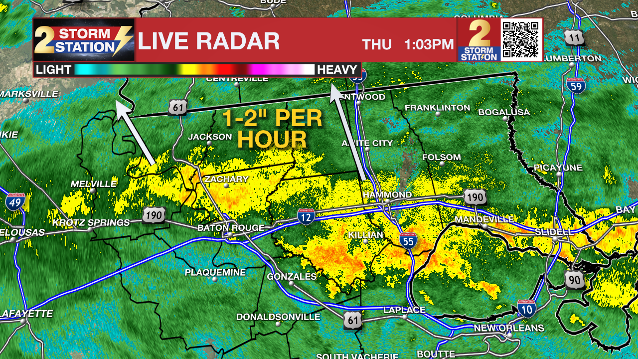
A FLASH FLOOD WARNING remains in effect for North Central Ascension Parish, East Baton Rouge Parish, and West Central Livingston Parish until 1:30 pm. Flash flooding is ongoing or expected to begin shortly in these areas. Flooding of small creeks and streams, urban areas, highways, streets and underpasses as well as other poor drainage and low-lying areas.
Please do not drive across flooded areas. Report observed flooding to the Storm Station via weather@wbrz.com or local emergency services when you can do so safely.
Trending News
The National Weather Service has issued a FLOOD WATCH for all parishes along and south of I-10/12, including the city of Baton Rouge, through Saturday morning. You should monitor later forecasts and be alert to possible warnings. Those living in areas prone to flooding should be prepared to take action should flooding develop and do not drive across a flooded area. An additional 2-4 inches of rain is expected in the watch area as a baseline, though isolated higher amounts are possible. Higher totals are more likely closer to the coast.
Tonight: Numerous showers and storms will continue into the overnight hours. The rain-cooled air will result in temperatures in the middle-70s overnight. With little dry time, roadways will likely be slick during the early Friday morning commute with heavy downpours possible during commute hours as well.
Friday: Soggy conditions will persist on Friday from sunrise to sunset as deep tropical moisture remains over the region. Late Friday night, dry air will move in from the northwest. The exact timing is difficult to pinpoint, but rain showers will begin to dissipate from north to south on Friday night. The trends suggest some rain could linger into a few high school football games. It would be a good idea to take a poncho to your game of choice. It will be cool on Friday night with temperatures in the mid-70s.
This Weekend: A front will pass through the area by early Saturday morning, replacing the rainy conditions with much drier air. Cloud cover will hang around early on, but skies will clear during the day. Expect comfortable conditions for tailgates and football games for both LSU and Southern. Look for a high temperature in the upper-80s with sunshine and low humidity on Saturday. A northerly breeze between 10-20 mph will be around as well. Another shot of dry air on Sunday is likely to bring the driest and coolest air felt since early June. We might be able to classify that incoming air mass as the first taste of fall this season.
Up Next: Morning lows Sunday and into the first part of next week will dip below average for early September, into the low and middle-60s each day. Afternoons will also be very comfortable as highs in the upper-80s will be accompanied by plenty of sunshine and low humidity.
Get the latest 7-day forecast and real time weather updates HERE.
Watch live news HERE.
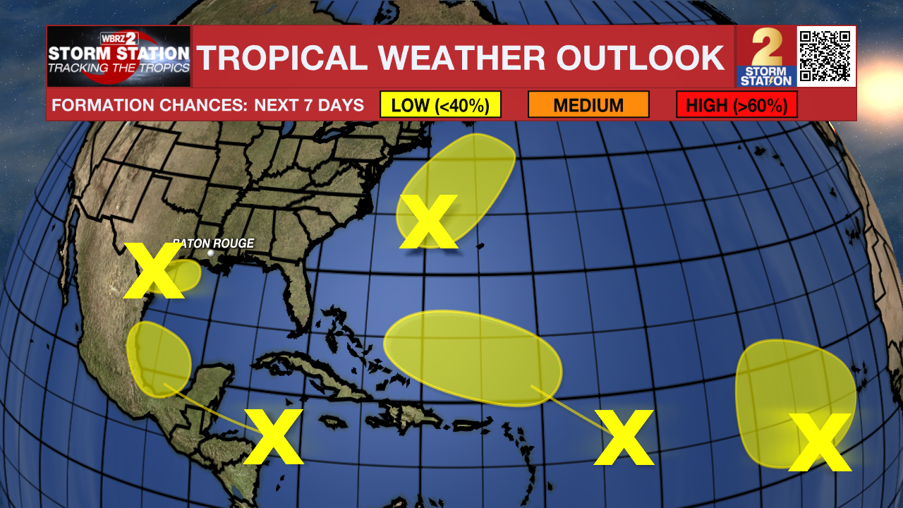
The Tropics: There are several areas of interest in the Atlantic Basin, all of which have low chances of tropical development in the next week.
A trough of low pressure is producing widespread disorganized showers and thunderstorms across the northwestern Gulf of Mexico, including southern Louisiana. Upper-level winds are expected to become less conducive for development by Friday and Saturday as a frontal boundary approaches the system.
A tropical wave moving quickly westward at about 20 mph is producing a broad area of thunderstorms across the central Caribbean Sea. Some development is possible into next week as the system emerges over the southwestern Gulf of Mexico. This wave poses no immediate cause for concern locally, but it is worth keeping an eye on this disturbance in the long-term.
A non-tropical area of low pressure located a few hundred miles east of North Carolina might acquire some subtropical characteristics over the next few days as it moves northeastward. Fortunately, the system will remain offshore and does not appear to be a big threat to land at this time.
Another tropical wave located over the eastern tropical Atlantic remains disorganized. Slow development of this system is possible in the coming days as it drifts northwestward.
An additional tropical wave is located farther to the west in the central tropical Atlantic. This wave also remains disorganized. Slow development is possible in the next few days. However, conditions will become less favorable for development by the end of the week.
– Emma Kate C.
The Storm Station is here for you, on every platform. Your weather updates can be found on News 2, wbrz.com, and the WBRZ WX App on your Apple or Android device. Follow WBRZ Weather on Facebook and Twitter for even more weather updates while you are on the go.
More News
