

Latest Weather Blog
Tuesday AM Forecast: Tracking widespread rain and first Fall front
After a hot and steamy start to the work week, the Storm Station is tracking the next rainmaker on Wednesday and a front that will bring the first taste of fall to southern Louisiana over the weekend.
Today & Tonight: Tuesday will be another hot and steamy day with afternoon high temperatures climbing into the middle and upper 90's around the Capital Area. Feels-like conditions will skim just below Heat Advisory criteria Tuesday afternoon so it is highly suggested to continue to practice heat safety when outdoors. Skies will remain mostly to partly sunny all day with only one or two spotty showers this afternoon. Tuesday night conditions will be slightly more muggy as moisture begins to pool in and we transition to a wetter pattern for the second half of the workweek. Overnight lows will only dip down near 77 degrees.
Up Next: Throughout the day on Wednesday we will watch conditions shift to a rainier, more dreary pattern. Some sunshine early Wednesday will allow temperatures to peak in the lower 90's before rain begins during the day. Coverage of showers and storms will likely begin spotty and increase throughout the afternoon hours. Approximately 80% of WBRZ's 13 parish & 2 county coverage area will see rainfall on Wednesday with even greater (+90%) expected Thursday. Each day you will want to monitor the radar closely and keep raingear handy. Scattered showers will likely linger into Friday as well with 2-4" of rainfall accumulation possible over the three days. The rainy conditions will limit high temperatures to the 80's to end the workweek.
Those showers and thunderstorms will be motivated by a front moving in from the north that will pass through the region Friday afternoon into Saturday morning. As it does, much drier air will filter in behind the system, eliminating rain over the weekend and dropping humidity levels down significantly. The front will bring a refreshing touch of fall-like air to the region, most noticeable in early morning temperatures that will dip into the middle-60's for the first time in months!
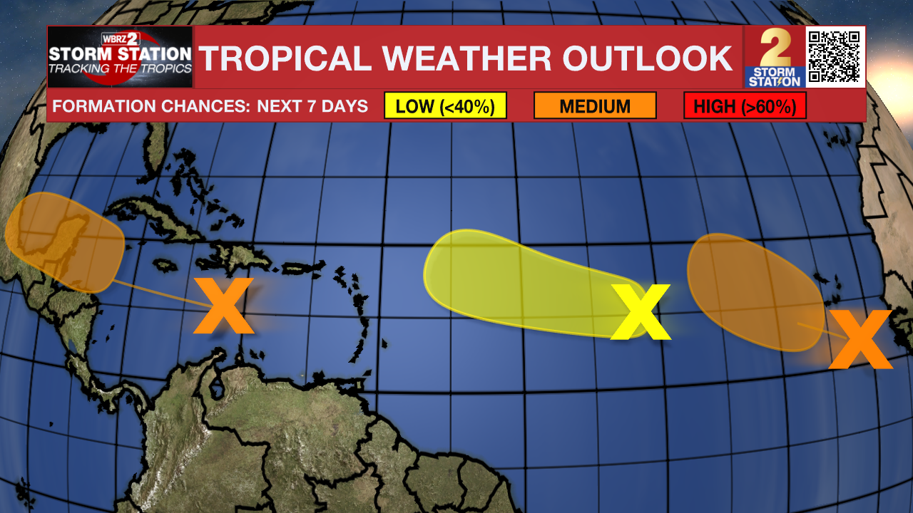
The Tropics: A tropical wave is producing disorganized thunderstorms and gusty winds across portions of the Lesser Antilles, Puerto Rico, Hispaniola and over the adjacent waters. As the system continues west over the next several days, environmental conditions are forecast to become more conducive for development. By late this week or over the weekend, and a tropical depression could form.
A tropical wave over the far eastern Atlantic is producing disorganized showers and thunderstorms. Environmental conditions are forecast to become a little more conducive for development, and a tropical depression could form later this week while the disturbance moves slowly west-northwestward or northwestward over the eastern tropical Atlantic Ocean.
Another tropical wave located about midway between the west coast of Africa and the Lesser Antilles is producing disorganized showers and thunderstorms. Some slow development is possible during the next couple of days while the system moves west-northwestward. By the end of the week, however, environmental conditions are expected to become unfavorable for additional development.
Trending News
Get the latest 7-day forecast and real time weather updates HERE.
Watch live news HERE.
– Emma Kate C.
The Storm Station is here for you, on every platform. Your weather updates can be found on News 2, wbrz.com, and the WBRZ WX App on your Apple or Android device. Follow WBRZ Weather on Facebook and Twitter for even more weather updates while you are on the go.
More News
