

Latest Weather Blog
FLOOD WATCH in effect through Saturday as widespread rain continues
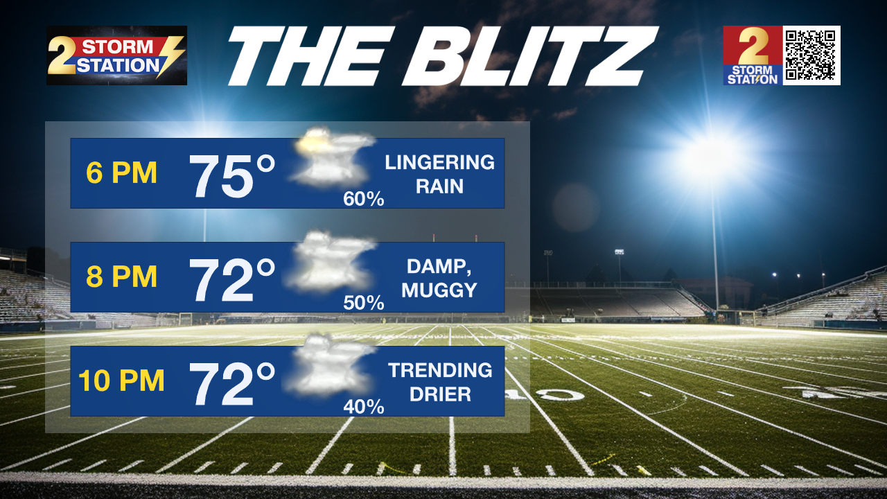
The threat for heavy rain and flash flooding remains through Friday. Keep rain gear available and check in with Storm Station forecast updates on the numerous outdoor events such as football games.
The National Weather Service has issued a FLOOD WATCH for all parishes along and south of I-10/12, including the city of Baton Rouge, through Saturday morning. You should monitor later forecasts and be alert to possible warnings. Those living in areas prone to flooding should be prepared to take action should flooding develop and do not drive across a flooded area. An additional 2-4 inches of rain is expected in the watch area as a baseline, though isolated higher amounts are possible. Higher totals are more likely closer to the coast. Please do not drive across flooded areas. Report observed flooding to the Storm Station via weather@wbrz.com or local emergency services when you can do so safely.
Tonight: Numerous showers and storms will continue through the overnight hours. A tropical air mass will maintain a very humid feel and low temperatures will stay in the mid 70s.
Friday: Roadways will likely be slick during the early morning commute with isolated downpours possible as well. As deep tropical moisture remains over the region, periods of rain and embedded thunderstorms are expected through the day. A risk for heavy rain creating isolated street and poor drainage flooding will continue, especially along and south of the I-10/12 corridor. At a minimum, scattered showers will linger into the evening hours as high school football games are getting underway. Dry air is expected to move in from north to south through the night which will bring an end to precipitation. The exact timing is difficult to pinpoint, but trends still suggest that the Metro Area will dry out by sunrise Saturday.
Trending News
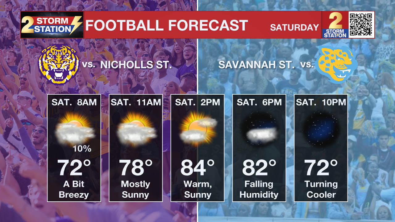
This Weekend: A front will pass through the area by early Saturday morning, replacing the rainy conditions with much less humid air. It is worth noting that some showers could linger south of I-10 and closer to the coast. Clouds will be stubborn to break but gradual, north to south clearing is anticipated through the day. A northerly breeze between 10-20 mph will be around as well. Those setting up tailgates for the first LSU and Southern home games can expect generally cooperative conditions and a mainly clear, comfortable evening will welcome kickoff. A reinforcing shot of dry air on Sunday is likely to bring the driest and coolest air felt since early June. We might be able to classify that incoming air mass as the first taste of fall this season.
Up Next: Morning lows Sunday and Monday will dip below average for early September, into the mid 60s each morning. Afternoons will also be very comfortable as highs in the upper 80s will be accompanied by plenty of sunshine and low humidity. Rain will make a prompt return by Tuesday.
Get the latest 7-day forecast and real time weather updates HERE.
Watch live news HERE.
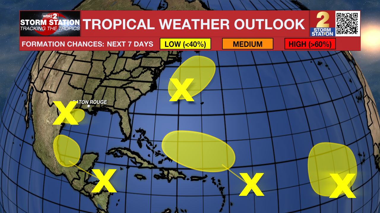
The Tropics: A large area of showers and thunderstorms continue in association with a broad area of low pressure interacting with a weak frontal boundary located over the northwestern Gulf of Mexico. Upper-level winds are expected to become less conducive for development by late Friday and Saturday as another frontal boundary approaches the system. Although development is unlikely, heavy rainfall is expected across portions of the northern Gulf Coast during the next day or so.
Showers and thunderstorms have become better organized in association with a non-tropical area of low pressure located a few hundred miles east of North Carolina, and recent satellite data indicates the system is producing winds to near gale-force. This system could acquire some tropical or subtropical characteristics over the next day or two while it moves generally north-northeastward, remaining offshore of the northeastern United States. Once the low moves over cooler waters by early Saturday, further development is not expected.
An elongated trough of low pressure over the eastern tropical Atlantic is producing limited shower activity. Development is not expected through this weekend while the system moves little. Some slow development appears possible early next week when the disturbance begins moving slowly northwestward.
Shower and thunderstorm activity remains disorganized in association with a westward-moving tropical wave located over the western Caribbean Sea. Development is not expected before the system reaches Belize and the Yucatan Peninsula by early Friday. Some gradual development is possible late in the weekend into early next week after the system emerges over the southwestern Gulf of Mexico.
Another tropical wave located a few hundred miles east of the Leeward Islands is producing limited shower and thunderstorm activity. Strong upper-level winds are expected to inhibit development of this system during the next few days while it moves west-northwestward at 10 to 15 mph. By early next week, environmental conditions could become more conducive for some slow development while the system moves over the southwestern Atlantic Ocean.
The Storm Station is here for you, on every platform. Your weather updates can be found on News 2, wbrz.com, and the WBRZ WX App on your Apple or Android device. Follow WBRZ Weather on Facebook and Twitter for even more weather updates while you are on the go.
More News
