

Latest Weather Blog
Wednesday PM Forecast: Highs scale back temporarily as rain chances rise
UPDATE - 10 p.m. Wednesday: A narrow cluster of storms has developed this evening to the southwest of Baton Rouge. These storms are not moving very quickly, and appear to be hugging a boundary - likely a remnant lake breeze boundary emanating from Lake Pontchartrain and Maurepas. These storms will likely diminish as we continue to lose daytime heating effects into the night.
945p Wednesday:
— Malcolm Byron (@mbyronwx) May 2, 2024
Well hello there, storms! Most of the green is ground clutter, but the deep shades of red indicate heavy rain in a narrow region extending from Addis to Geismar.
Evidently, there's enough convergence along a remnant lake breeze boundary to pop a storm! #LAwx pic.twitter.com/fzxNb9rF44
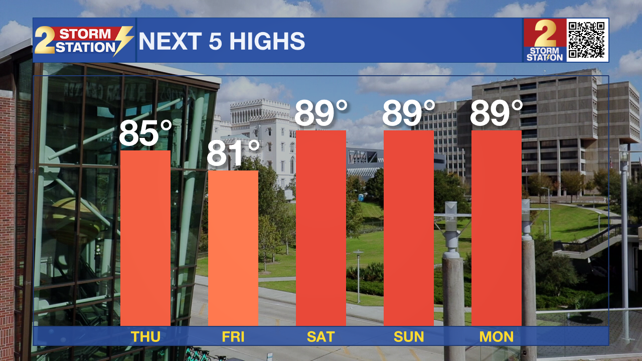
ORIGINAL STORY: After reaching 90° for the first time this year, temperatures will scale back as a few disturbances swing through. This will only be temporary - the warmth surges back into the area over the weekend.
Tonight & Tomorrow: Although we keep mostly clear skies for the first few hours of the evening, clouds will be on the increase into Thursday morning. We’ll wake up to cloudy skies early Thursday, with warmer overnight lows. Temperatures will bottom out near 70° in the capital city. A few patches of fog are possible, although a slight southeasterly breeze appears just strong enough to alleviate fog concerns.
Trending News
More clouds will be with us on Thursday. That will help bring highs back into the middle-80s. A weak disturbance will bring isolated to widely scattered showers and storms to the region. Rain chances increase closer to lunchtime, lasting into the afternoon. It will be a good idea to have the rain gear on hand. Even so, know that it will not be raining at every point. Some spots might even dodge rain entirely.
Up Next: An additional disturbance arrives on Friday, bringing another shot at showers and storms. Rain chances peak during the morning this time. Lingering storms are possible during the afternoon, but this activity will be closely tied to how the morning unfolds. For instance, a stormier morning would stabilize our atmosphere and prevent the afternoon round.
Cloud cover and rain will hold temperatures back for yet another day on Friday. However, all bets are off thereafter. Highs return to the upper-80s over the weekend and nudge upward into the low-90s next week. There will be plenty of humidity to go around, with limited rain chances also.
Get the latest 7-day forecast and real time weather updates HERE.
Watch live news HERE.
-- Meteorologist Malcolm Byron
The Storm Station is here for you, on every platform. Your weather updates can be found on News 2, wbrz.com, and the WBRZ WX App on your Apple or Android device. Follow WBRZ Weather on Facebook and Twitter for even more weather updates while you are on the go.
More News
