

Latest Weather Blog
Tuesday PM Forecast: dip in humidity making the 90s feel more tolerable
Although highs will remain in the upper-90s, lower humidity will make it feel more tolerable for a few days. Even more notable will be the dip in overnight lows, making it feel a little more refreshing in the morning.
Tonight & Tomorrow: The lower humidity has arrived, and that will drop the floor for temperatures on Tuesday night. Look for a low temperature near 70° in Baton Rouge under clear skies. Some neighborhoods might even dip into the 60s, especially outside of the city and north of the interstate. Wednesday will bring mainly sunny skies. Abundant sunshine will help nudge temperatures into the upper-90s. But the humidity will drop even lower making the heat feel more tolerable. Feels-like temperatures will only be a couple degrees above the air temperature - hardly noticeable.
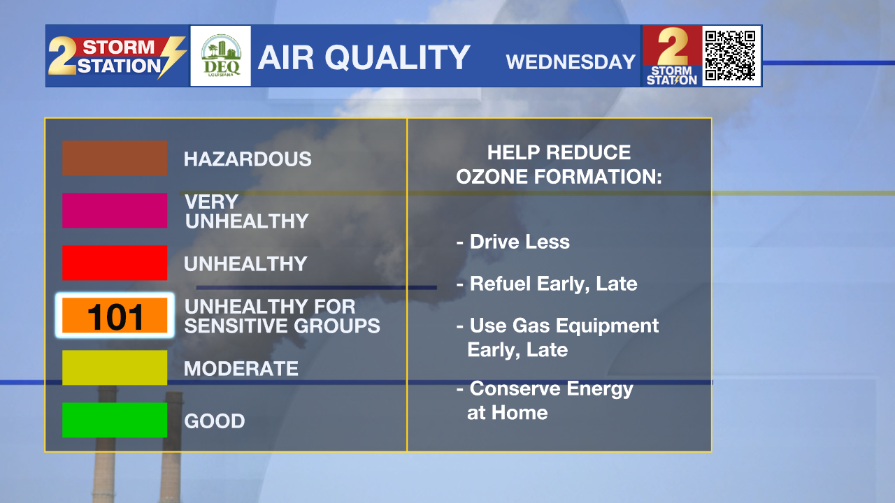
Tuesday, partly to mostly sunny skies and temperatures in the mid-90s will promote ozone formation. Furthermore, light north-northeasterly winds will reduce dispersion and gradually transport smoke from Canadian wildfires into the Bayou State, increasing particle concentrations and ozone precursors. This area includes East Baton Rouge, West Baton Rouge, Iberville, Livingston, Ascension and Pointe Coupee parishes. The weather conditions will be favorable for the formation of ozone. The Air Quality Index indicates that ozone will be at the orange level, which is Unhealthy for Sensitive Groups. Increasing ozone levels may cause unhealthy air quality during afternoon hours. Active children and adults, the elderly and people with respiratory diseases, such as asthma, should avoid prolonged outdoor activities and exertion.
Up Next: Thursday will feature a continuation of the low humidity, with an exception for coastal locations. Highs will reach the upper-90s again, and sunshine will prevail. The humidity begins to surge north on Friday. By the weekend, the air will have more of a sticky feel. Not only will this push feels-like temperatures slightly higher over the weekend, but added moisture will re-introduce isolated thunderstorms into the forecast. There will also be an weak upper-level disturbance along the Gulf Coast this weekend, which might assist in afternoon thunderstorm development.
Trending News
The Tropics: Ernesto became post-tropical on Tuesday morning. There are now no active tropical systems in the Atlantic, and none are forecast to develop in the next seven days.
Get the latest 7-day forecast and real time weather updates HERE.
Watch live news HERE.
-- Meteorologist Malcolm Byron
The Storm Station is here for you, on every platform. Your weather updates can be found on News 2, wbrz.com, and the WBRZ WX App on your Apple or Android device. Follow WBRZ Weather on Facebook and Twitter for even more weather updates while you are on the go.
More News
