

Latest Weather Blog
NEW: officials determine April 10 tornado in West Feliciana Parish was on ground for 33 miles
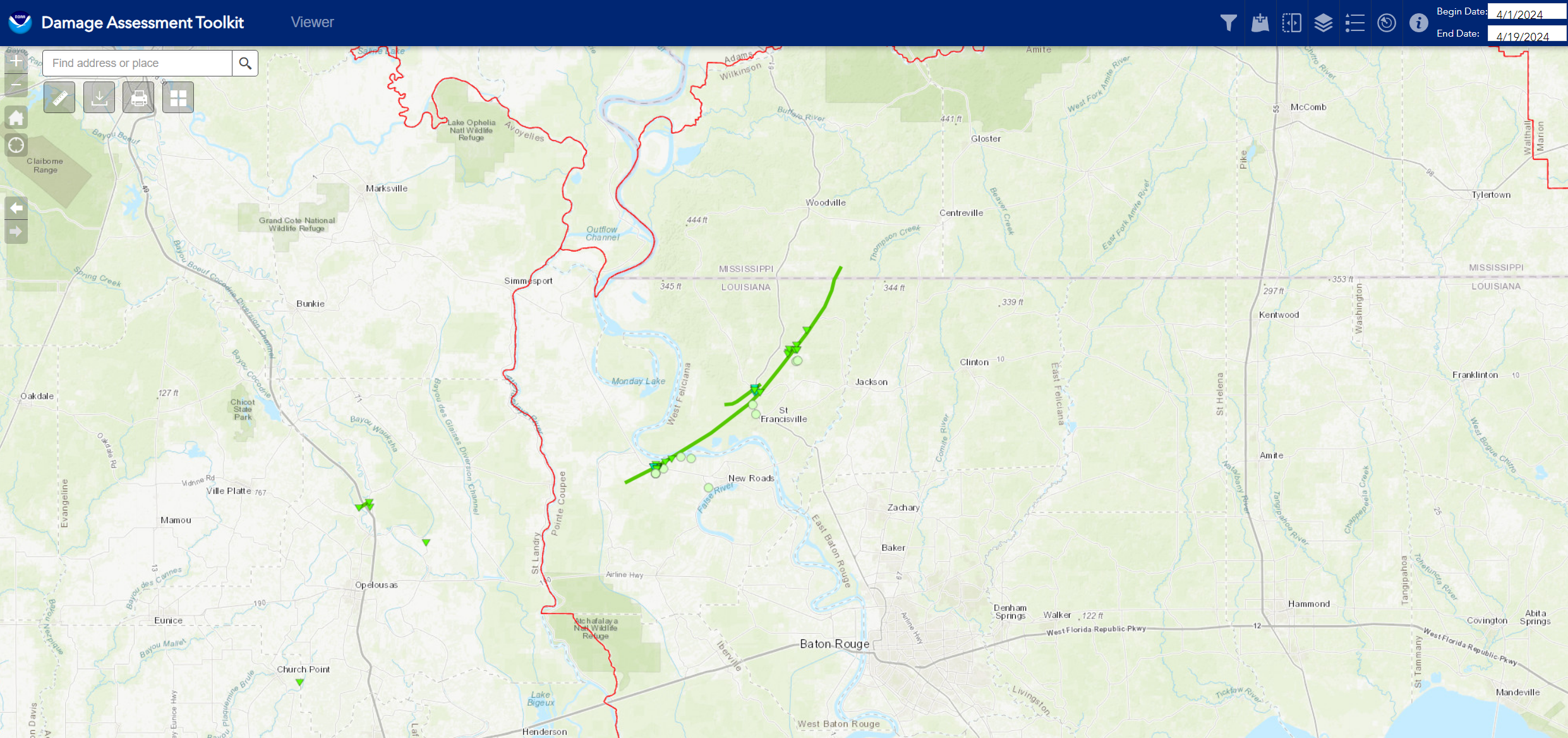
Ongoing storm surveys have found that a strong, long tracking tornado tore across portions of Pointe Coupee and West Feliciana Parishes during severe weather on April 10. This single tornado was previously believed to be two separate tornadoes. Additionally, a second tornado was identified just northwest of the new, long tracking tornado.
Officials from the National Weather Service (NWS) used recent satellite data to find signs of additional tornadoes. Not only were several previously undetected tornadoes identified in St. Tammany Parish and Hancock County, but one of the West Feliciana Parish tornadoes was discovered to be on the ground continuously for 33 miles with a maximum width peaking near 1 mile near Spillman, LA. This tornado ranks as the second longest continuously on the ground in the Storm Station's 13 Parish, 2 County forecast area (since 1950).
Trending News
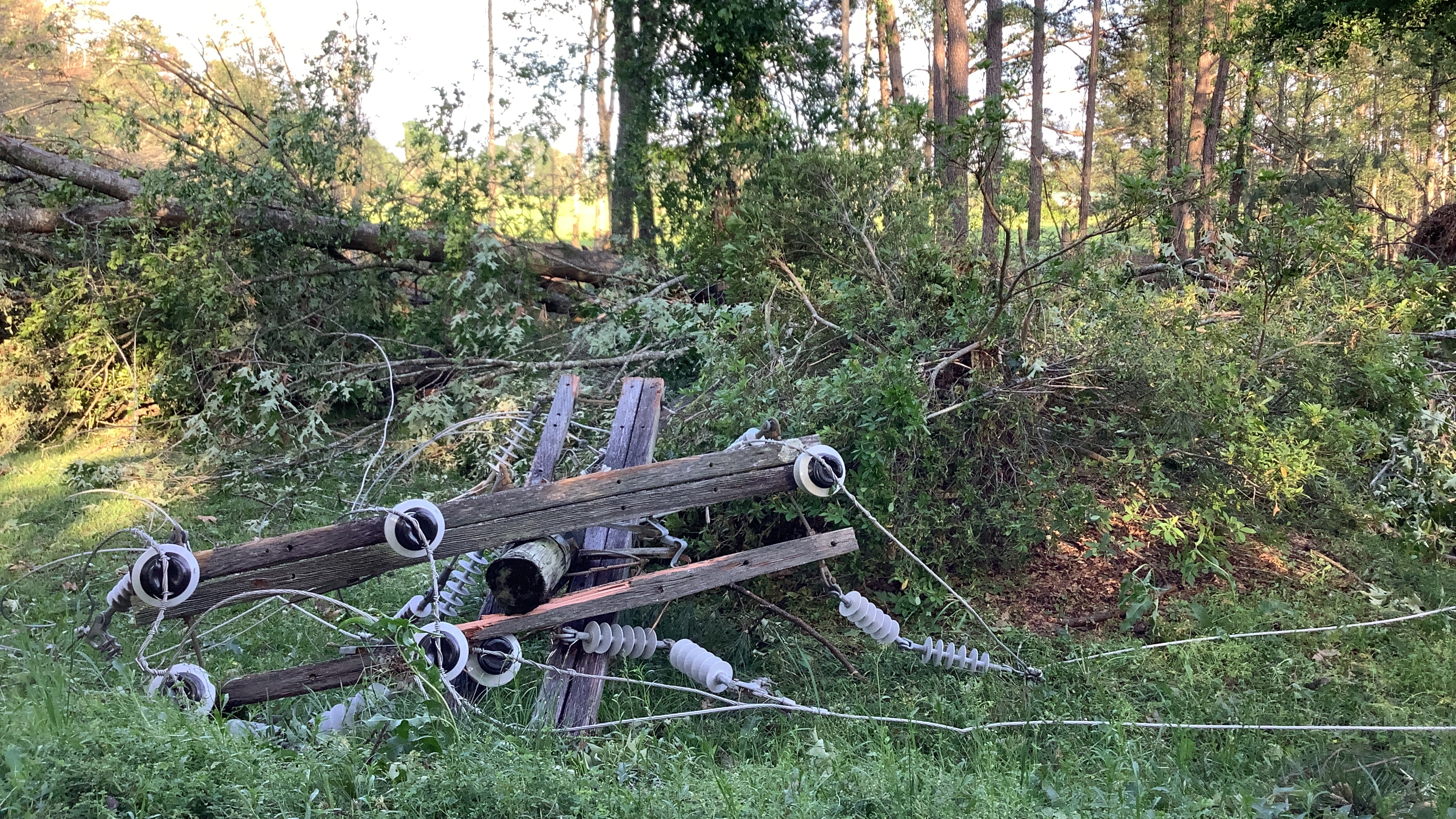
This EF-1 tornado with maximum winds of 110mph formed south of Morganza, LA within a powerful line of thunderstorms and quickly moved northeast over mainly rural lands before causing more substantial tree damage as it crossed Morganza Highway. The tree damage became increasingly more widespread and intense as the tornado crossed Levee Road and the Mississippi River. High resolution satellite imagery identified a focused swath of tree damage roughly 400 yards in width that continued northeast through the Cat Island National Wildlife Refuge up through US Highway 61. Tree damage was observed on Highway 61 with another large swath of tree damage further northeast on Bains Road. Due to the heavily wooded and rural areas, ground surveys were impeded in identifying parts of this track as it continued northeast. The tornado quickly grew in size thereafter and the most significant damage began after the tornado crossed Polk Brannon Road. Ground survey was able to access areas along Spillman and Jones Vaughn Creek Road where numerous trees were snapped, large hardwood trees were uprooted, and several wooden electrical transmission poles were snapped. The peak width of the damage path was measured in this vicinity with widespread damage evident along a mile wide swath. Ground surveys were impeded in Spillman due to widespread tree damage from this tornado, but the damage path and track remained wide and significant as it tracked northeast along Highway 421. High resolution satellite analysis was used to provide the end point for this tornado in which the tornado finally lifted after crossing into rural parts of Wilkinson County in Mississippi.
Further adjustments to peak intensity are possible and another damage survey team from the National Weather Service is planning to revisit the area on Monday. This will assist in finalizing the peak intensity and an increase to an EF-2 rating tornado in West Feliciana Parish is likely.
The second EF-1 tornado with maximum winds of 100mph was confirmed via radar imagery and ground survey. The starting point of this tornado was along the bend of Bayou Sara. The tornado then quickly tracked northeast into Bains where it crossed US Highway 61 causing primarily tree damage near an elementary school. Additional damage was not accessible due to Marydale Road being closed, but high resolution satellite imagery did identify a localized swath of tree damage near Alexander Creek tracking just west of the larger tornado that occurred in this area.
The Storm Station is here for you, on every platform. Your weather updates can be found on News 2, wbrz.com, and the WBRZ WX App on your Apple or Android device. Follow WBRZ Weather on Facebook and Twitter for even more weather updates while you are on the go.
More News
