A weak cool front passing through this morning will deliver some perfect spring weather through the weekend. Get outside and enjoy the great conditions, but make sure you bring the sunscreen!
Today & Tonight: This morning, a cool front is moving through the local area. Expect a bit lower highs today, and some breezy conditions at times. Highs will rise into the upper 70s under completely sunny skies. Winds will be out of the NNW at 7-17 mph, with some gust 20-25 mph. Temperatures will rapidly drop after the sun sets. Lows will be a bit chilly Saturday morning, in the upper 40s.
Weekend & Beyond: The weekend forecast is looking excellent! Saturday will feature lots of sunshine and highs in the middle 70s. Sunday will start off a bit chilly, but warm into the lower 80s.
Heading into early next week, temperatures will stay warm, in the 80s. Mornings will be a bit milder, in the upper 50s and low 60s. A weak front is expected to pass through Tuesday night, but low moisture content will limit rain, with only brief spotty showers expected. Temperatures will only slightly dip behind this front. In general, expect more great weather conditions next week, with no major rainmaker in the forecast.
River Flooding: The National Weather Service has issued a RIVER FLOOD WARNING for the Mississippi River at Red River Landing until May 5. Flood stage is 48 feet. Moderate flooding is expected with a crest near 57 feet on April 22. At these levels, Angola farmland on the left bank becomes inundated. Caution is urged when walking near riverbanks.
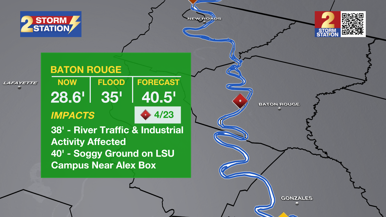
In addition, the Mississippi River gauge at Baton Rouge is projected to reach minor flood stage on Monday. Flood stage is at 35 feet. Major flood stage is expected on April 23 with a crest near 40 feet. Although "major flooding" sounds daunting, the city of Baton Rouge will see no impacts due to levee protection. However, industrial activity and navigational traffic on the river side of the levee will see impacts.
The National Weather Service has also issued a RIVER FLOOD WATCH for the Atchafalaya River at Simmesport, Butte La Rose, and Morgan City until further notice.
• At Simmesport, flood stage of 40 feet may be reached by April 24. There will be flooding of areas inside the levees of the Atchafalaya Floodway and considerable flooding in the backwater storage area in Avoyelles Parish.
• At Butte La Rose, flood stage of 20 feet may be reached by April 25. Minor flooding of the nearby areas could occur.
• At Morgan City, flood stage of 6 feet may be reached by Wednesday morning. At 7 feet, buildings at the foot of Ann Street on the river side of the flood wall will flood as water overtops the Rio Oil Company dock. Buildings on the river side of the Berwick floodwall will flood. River traffic restrictions will be strictly enforced. In addition, backwater flooding could potentially impact portions of areas around Lake Palourde and Stephensville.
The Storm Station is here for you, on every platform. Your weather updates can be found on News 2, wbrz.com, and the WBRZ WX App on your Apple or Android device. Follow WBRZ Weather on Facebook and X for even more weather updates while you are on the go.