

Latest Weather Blog
Wednesday Morning Video Forecast
Related Story
Relief from the record warmth we've experienced all summer is so close we can almost feel it! With two more days of temperatures in the 90s, a cold front we have been tracking all week is set to arrive and bring noticeable changes by the weekend.
Today & Tonight: High temperatures will rise into the low 90s this afternoon, adding to the record number of days spent at or above 90° this year. Skies will remain partly sunny with rain chances that are unlikely today. Overnight, some clouds will stick around keeping the low temperatures in the low 70s to high 60s range across southern Louisiana.
Up Next: After one more afternoon into the low 90s, the first noteworthy cold front of the fall season will begin to press into the Gulf Coast region on Thursday. This front will be running into drier air locally and so a line and showers and thunderstorms is expected to be weakening on approach with only isolated activity making it into the area late into the afternoon and evening. As a secondary front swings in from the north, moisture pooling along the original front may aid in the development of a few more showers and thunderstorms, especially early on Friday. After a muggy start to Friday, humidity will gradually drop with major changes felt by the weekend. Saturday will begin with lows in the mid 60s followed by highs in the mid 80s, despite sunshine. The coolest temperatures so far this season are anticipated on Sunday and Monday morning with lows in the low to mid 50s and highs barely returning to the upper 70s and low 80s. With these changing temperatures breaking a long spell of warmth, you may need to consider a light jacket for morning and evening activities this weekend and for the kiddos at the bus stop Monday morning.
Get the latest 7-day forecast and real time weather updates HERE.
Watch live news HERE.
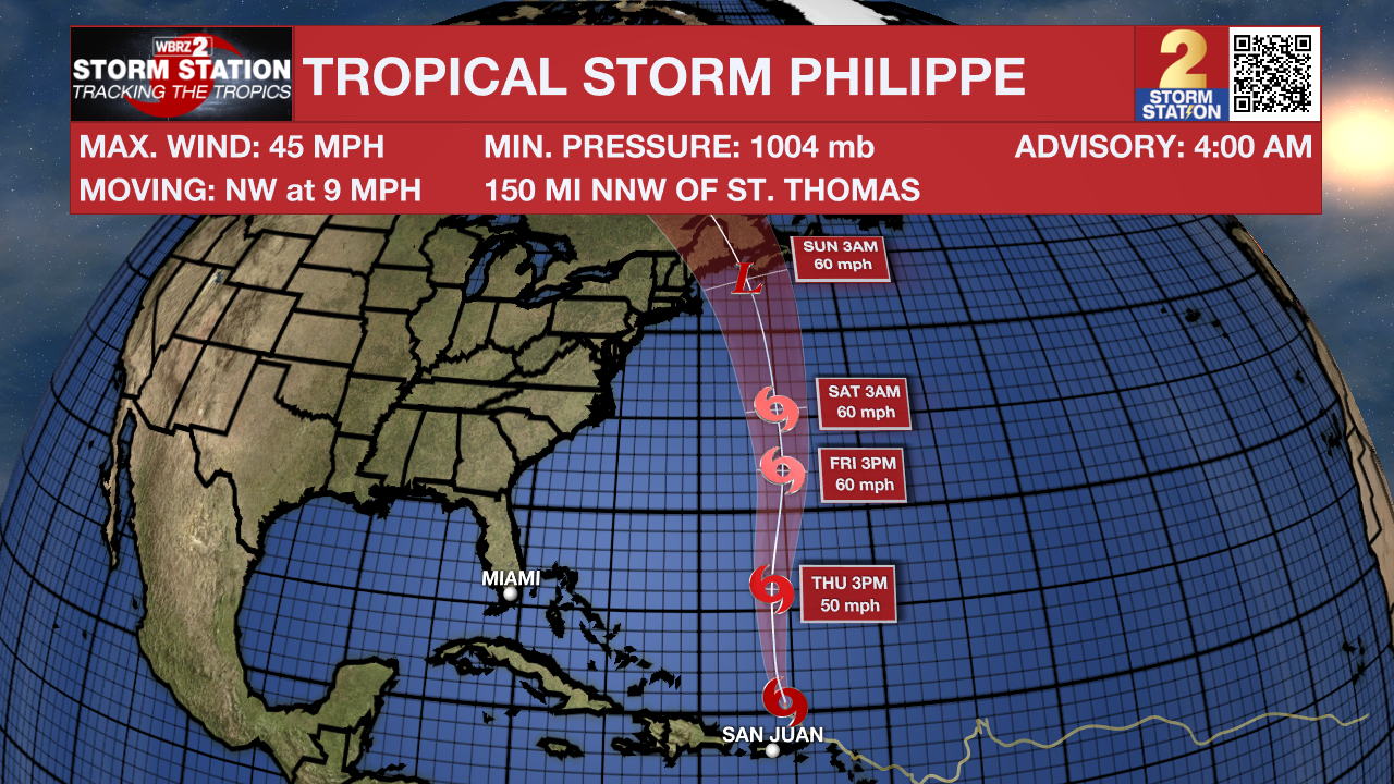
The Tropics: Tropical Storm Philippe is passing by the British Virgin Islands and remains poorly organized with maximum sustained winds of 45mph. Moving to the northwest at 9mph, the system is expected to turn more due north today and away from the islands. It is forecast to approach Bermuda Thursday night and Friday. Some slight strengthening could come over open water later in the week as the latest track indicates that the storm could impact parts of New England late this weekend.
– Josh
The Storm Station is here for you, on every platform. Your weather updates can be found on News 2, wbrz.com, and the WBRZ WX App on your Apple or Android device. Follow WBRZ Weather on Facebook and Twitter for even more weather updates while you are on the go.
News
