

Latest Weather Blog
Tuesday Midday Video Forecast
Related Story
Rain and clouds will continue through midweek until ridging takes over, cranking the heat up again.
Today & Tonight: A few showers will accompany the dreary morning conditions on Tuesday. Clouds will occupy the skies all day Tuesday, with scattered showers and thunderstorms likely this afternoon. Some of the storms could contain heavier downpours although widespread flooding remains unlikely. Temperatures today will begin in the 70's and warm only about 10°, into the middle and upper 80's this afternoon. Winds Tuesday will also be a bit breezy, between 10-20 mph. After nightfall, any rain activity is expected to dwindle, with mostly cloudy skies remaining in place. Overnight lows will return to the mid-70's.
Up Next: The dreary weather pattern will take a drier, and in response, warmer, shift by mid-week. Wednesday will remain mostly cloudy, keeping an isolated chance for storms in the afternoon hours with sustained winds out of the E at 15-25 mph all day. Despite lack of sunshine Wednesday, high's will warm in to the low-90's. Thursday and through the weekend, sunshine will return to the Capital Region, drying us up and sending temperatures each day well into the 90's. We will see no relief from humid air over the next week, so while we do trend drier, we cannot rule out a summertime pop-up storm or two each afternoon.
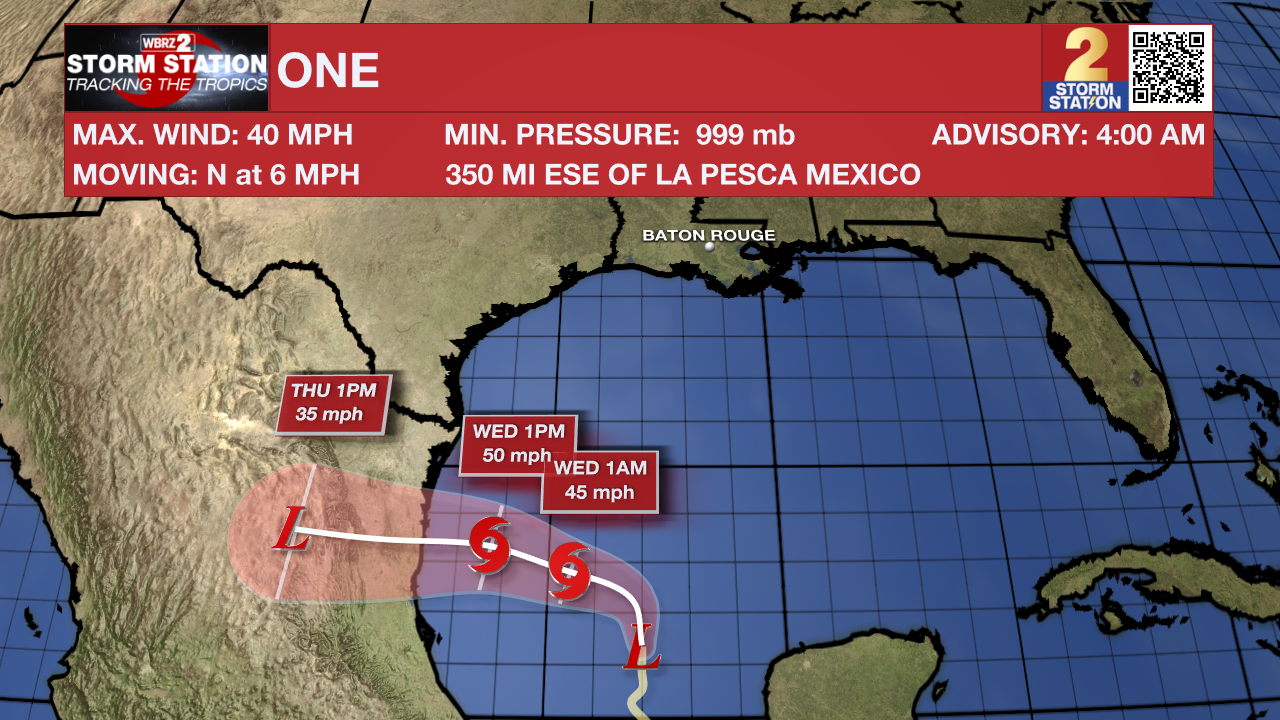
The Tropics: A low pressure system in the Bay of Campeche has been designated Potential Tropical Cyclone One. This designation is used by the National Hurricane Center when a system has not officially become a depression or storm but is expected to with imminent impact to land. No direct impacts are anticipated for the Capital Area. However, increased tropical moisture surrounding this system will aid in additional development of showers and thunderstorms through Tuesday. Gusty winds up to 35mph are possible, especially near the coast. You can view the complete forecast and outlook, HERE.
An area of cloudiness and thunderstorms located several hundred miles east of the Bahamas is associated with a surface trough and an upper-level area of low pressure. Environmental conditions could be conducive for some development of this system during the next few days while it moves westward or west-northwestward. The system is forecast to approach the coast of the southeast United States on Thursday or Friday.
Get the latest 7-day forecast and real time weather updates HERE.
Watch live news HERE.
– Emma Kate Cowan
The Storm Station is here for you, on every platform. Your weather updates can be found on News 2, wbrz.com, and the WBRZ WX App on your Apple or Android device. Follow WBRZ Weather on Facebook and Twitter for even more weather updates while you are on the go.
News
