

Latest Weather Blog
Thursday evening video forecast
Related Story
While the stretch of record (and near record) warmth continues, a pair of cold fronts is in the forecast. You will be reaching for a jacket again after the second one passes.
Tonight & Tomorrow: Clouds will increase tonight as a weak cold front drifts south into the area. Light, southwest winds ahead of this front will keep temperature well above average, in the upper 60s. On Friday morning, a couple of showers will be possible as a cold front sags south toward the Gulf Coast and falls apart. The best chance for one of those stray, light showers will come north of I-10. Other than an isolated damp spot on roads, there will be no significant impacts. In fact, some sunshine will get into the mix during the afternoon hours. Any temperature changes with this first cold front will be negligible and high temperatures will get into the upper 70s.
LSU Baseball: Expect nice weather for LSU Baseball this weekend. Two consecutive 6:30pm games against Samford on Friday and Saturday will feature partly cloudy skies with temperatures falling through the 70s. You might want a light jacket, especially on a breezy, cooler Friday night. The first pitch on Sunday afternoon will have warmer temperatures in the low 80s and a stray shower is not out of the question, especially toward the end of that game.
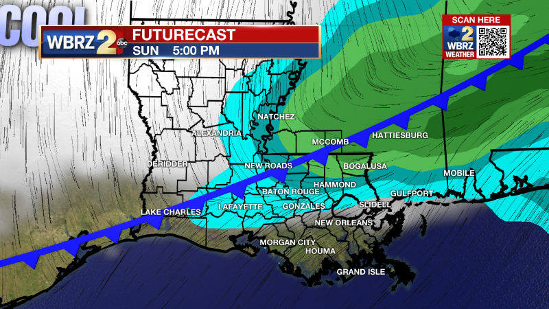
Up Next: On Saturday, low temperatures in the 50s will quickly warm into the 80s with partly sunny skies during the afternoon. Remember to set the clocks ahead one hour before going to bed! Another cold front will move toward the area on Sunday. An unseasonably mild day is on tap with lows in the upper 60s and highs in the mid 80s. Clouds will increase through the day and by late afternoon, the cold front will move into the region and could trigger isolated showers and thunderstorms. Sunday does not look to be a washout, with most activities staying dry through most of the (extended) daylight hours. Those isolated showers and thunderstorms will be possible well into the night, but any lingering rain will wrap up with drier and much cooler conditions for the Monday morning drive. Especially Tuesday and Wednesday morning, a light jacket will come in handy as low temperatures dip into the low to mid 40s. Expect a couple of sunny afternoons with highs in the 60s.
Get the latest 7-day forecast and real time weather updates HERE.
Watch live news HERE.
Looking Beyond: Just after the 7-Day Forecast, we have eyes on a storm system that will bring a much better chance of organized rain, and possibly thunderstorms. The big question mark at the moment is on timing—will it be Friday or Saturday? Of course, a Saturday arrival could result in some tricky weather for the Wearin’ of the Green parade. Continue to check in with Storm Station meteorologists for the latest forecasts as details come into focus.
--Josh
The Storm Station is here for you, on every platform. Your weather updates can be found on News 2, wbrz.com, and the WBRZ WX App on your Apple or Android device. Follow WBRZ Weather on Facebook and Twitter for even more weather updates while you are on the go.
News
