

Latest Weather Blog
Sunday morning video forecast
Related Story
Beryl is nearing the Texas coast, and it should make landfall tonight as a hurricane. While the most major impacts will be in Texas, indirect impacts are possible in Louisiana.
Today & Tonight: Nothing too much out of the ordinary is expected today. Highs will get to near 97 degrees under partly to mostly cloudy skies. Feels like temperatures will approach 112 degrees. Heat advisory's have been posted for much of southeast Louisiana. In the afternoon and evening, some isolated pop up showers and storms will be possible. Tonight, some outer bands of Beryl should try to move through the area. Nothing too hazardous is expected with this. Coverage of rain looks isolated in nature. Lows will be near 79 degrees under partly to mostly cloudy skies.
Up Next: Tropical moisture will increase early next week as Beryl moves west of us. Monday will be similar to Sunday, but will have slightly greater rain coverage. The best chance of rain from Beryl will be Monday night and on Tuesday. Some of this rain could be heavy at times. Moisture from Beryl will last into Wednesday, creating the chance for more showers and storms. We return to a more typical "summer like" pattern Thursday and into the weekend with daily pop up thunderstorms. Temperature wise, rain will drop highs down to near 92 degrees on Tuesday. We will rebound back to the mid 90's by the end of the week.
The Tropics: Tropical Storm Beryl is nearing the Texas coast. Hurricane and tropical storm warnings have been posted. As of 7am Sunday, Beryl had 60mph winds and was moving northwest at 12mph. The storm will likely intensify to hurricane strength before a landfall in Texas tonight. Areas in the hurricane warning may expect storm surge along the coast, strong winds and heavy rain.
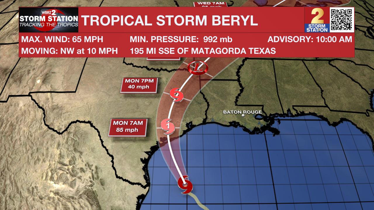
Local Impacts: Beryl will bring some indirect impacts to the local area early next week. Here is a summary:
- Rip Currents—dangerous rip currents will be possible along the Louisiana Coast and for beaches as far east as the Florida Panhandle. Extreme caution should be used in areas that are permitting swimming.
- Coastal Flooding—persistent onshore winds could lead to water inundation for immediate coastal areas around the Gulf of Mexico and the tidal lakes. Tides may run a few feet above average for several days.
- Heavy Rain—remnant moisture from the storm could end up over Louisiana and Mississippi early next week. The tropical moisture could lead to heavy thunderstorms and possibly some street and poor drainage flooding.
Get the latest 7-day forecast and real time weather updates HERE.
Watch live news HERE.
– Balin
The Storm Station is here for you, on every platform. Your weather updates can be found on News 2, wbrz.com, and the WBRZ WX App on your Apple or Android device. Follow WBRZ Weather on Facebook and Twitter for even more weather updates while you are on the go.
News
