

Latest Weather Blog
Sunday Morning Video Forecast
Related Story
An Excessive Heat Warning has been issued for the capital area on Sunday & Monday as the heat and humidity climb even higher. Take it easy outside, be sure to stay hydrated, and look out of the signs of heat illness in the days to come.
Today & Tonight: Sunday looks to be another very hot day across the capital region. High temperatures will soar into the upper-90s, with the humidity giving the air an unpleasant feel. Peak feels-like temperatures venture even higher, likely topping out in the 113-114° range. This meets the criteria for an Excessive Heat Warning, which will be in effect on Sunday for most of the capital area. Even for the few parishes not included in the warning, a Heat Advisory takes its place.
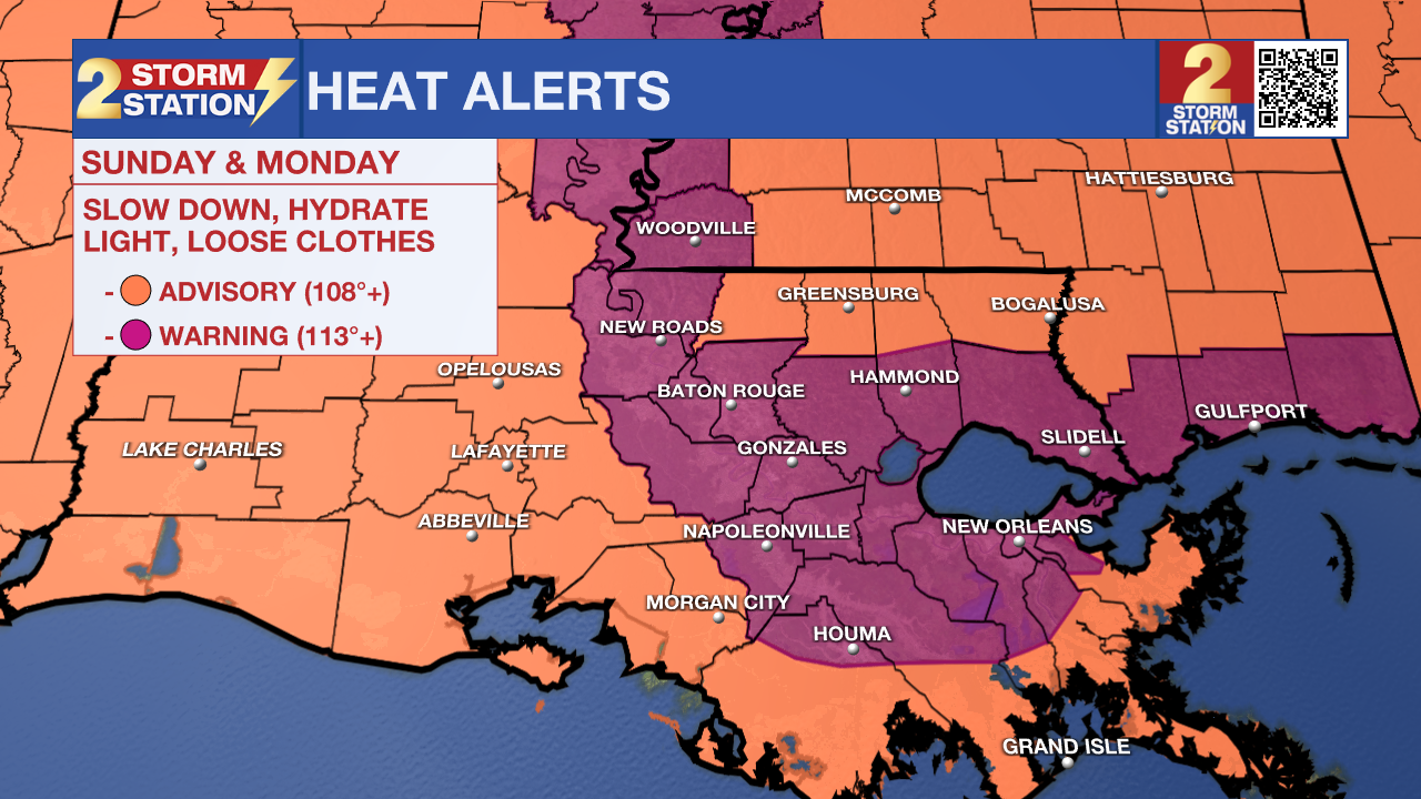
It's typically hot in the summertime, but this amount of heat and humidity is not as common. Especially if outside for long stretches, drink lots of water, take breaks, and be on the lookout for signs of heat illness. Children and seniors tend to be more vulnerable to heat illness, so it's not a bad idea to check in with friends and family.
With the heat and humidity, isolated showers and storms will develop into the afternoon. Rain will be far from a guarantee, but some might benefit from a rain-cooling shower. That activity tapers off into the night. Look for partly cloudy skies into Monday morning with an overnight low in the upper-70s to low-80s.
Up Next: The Excessive Heat Warning also carries over into Monday, feature similar heat to that of Sunday. More of the same is anticipated on Tuesday. Heat stress is cumulative, meaning that the impacts of heat on the body add up over several days. Stay hydrated, stay cool, and you should be just fine. Fortunately, isolated to scattered storms will pop up each afternoon providing the only form of heat relief. While temperatures may scale back a touch by midweek, it will still be plenty hot leading up to the Fourth of July.
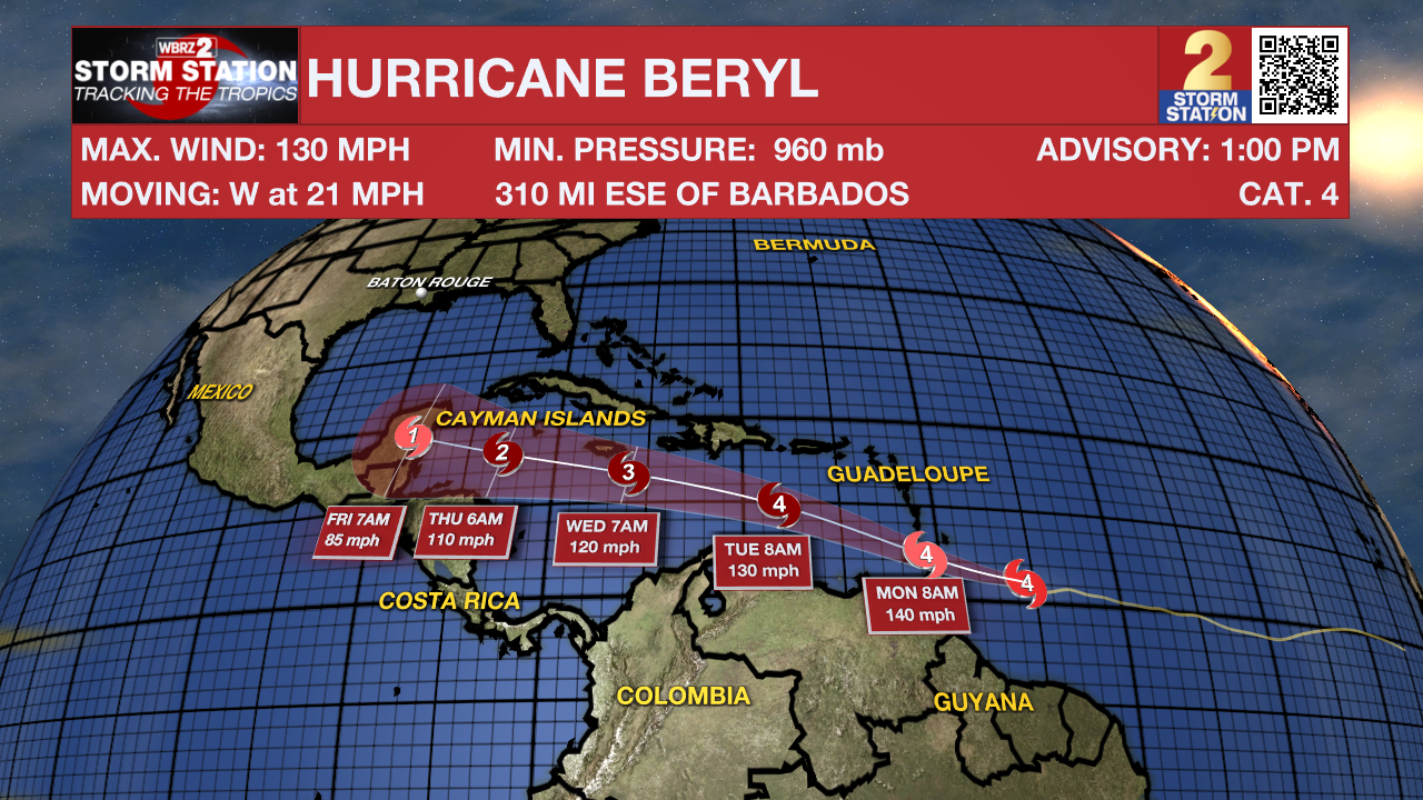
The Tropics: Hurricane Beryl attained Category 4 status shortly before 11 a.m. Sunday with maximum sustained winds at 130 mph. This marks the earliest Category 4 hurricane in the Atlantic on record in the calendar year, beating Hurricane Dennis (July 8, 2005). The system will continue to strengthen as it nears the Windward Islands. The latest forecast calls for maximum sustained winds at 140 mph on Monday morning. The hurricane will then push west through the Caribbean Sea. It is still too far out to know whether any part of the Gulf Coast will see any impacts long-term. For now, the Storm Station doesn't see any major signal for local impacts. That said, the Storm Station will also be monitoring this system very closely.
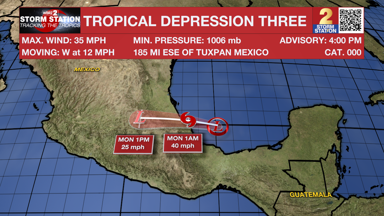
Meanwhile, Tropical Depression Three has formed in the southwest Gulf of Mexico. This system will make landfall on Sunday night in Mexico, making this a very short-lived storm. The latest forecast suggests that the system will become a tropical storm shortly before making landfall. Once that happens, it will become Tropical Storm Chris.
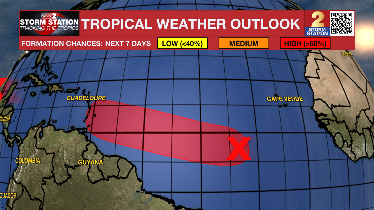
Another tropical wave located several hundred miles southwest of the Cabo Verde Islands has a high chance of development in the next week. A tropical depression will likely form by the middle of next week as it moves quickly to the west at 15-20 mph. It is worth noting that this system is following in the footsteps of Beryl.
Get the latest 7-day forecast and real time weather updates HERE.
Watch live news HERE.
-- Meteorologist Malcolm Byron
The Storm Station is here for you, on every platform. Your weather updates can be found on News 2, wbrz.com, and the WBRZ WX App on your Apple or Android device. Follow WBRZ Weather on Facebook and Twitter for even more weather updates while you are on the go.
News
