Sunday Morning Forecast
Related Story
BIG changes coming to the forecast for the start of your work week.
THE FORECAST
Today & Tonight: A beautiful start to your Sunday, waking up with temperatures in the low-70s and just a couple of clouds this morning. We are expecting ore clouds and moisture to build into the area as we head into the afternoon hours. A shower is possible but most people will stay completely dry today. Heat is what we are watching for one last day. The temperature to beat today is 93° set in 2016 and today’s forecast high is 95°. If we break the record today will be the 5th day in a row with record breaking heat for Baton Rouge. As we head into the overnight hours temperatures will really begin to cool down back into the low-70s for the start of your workweek.
Up Next: Waking up Monday morning some moisture will still be lingering in our area, and the effects of the cold front will not have fully set in yet. We will still be trying to break up this summertime pattern for most of the day. Daytime highs will top out in the low-90s, Monday afternoon. As the cold front sets in across the area, and we see winds shift out of the north, we will be seeing a more seasonable forecast. By Tuesday morning we begin to see even more changes in the forecast. Waking up with temperatures in the low-60s. Clear skies all day long, and temperatures much cooler than this past week. You can expect much less humidity starting Tuesday and into the rest of the work week. Starting your day with crisp cool morning with a little bit of warmth by the afternoon hours. Daytime highs for this week will top out in the mid-80s. Click here to see the 7-day forecast.
The Storm Station has you covered with hour-by-hour weather tracking is available for your location on the WBRZ WX App on your Apple or Android device. Follow WBRZ Weather on Facebook and Twitter for even more weather updates and unique weather insight from the whole team!
In the Tropics:

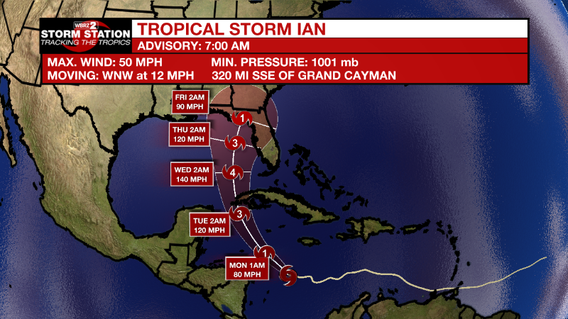
Tropical Storm Ian formed on Friday morning in the central Caribbean Sea. As of 7am Sunday maximum sustained winds now at 50mph. By Sunday and Monday, Ian will turn to the northwest and become a hurricane on approach to the Cayman Islands. Florida could be a target of then Hurricane Ian by the middle of next week.
Tropical Storm Gaston continues churning near the Azores with maximum winds of 50mph. The storm will bring heavy rain and wind to the islands while swinging around to the southeast and then south while gradually weakening.
Tropical Storm Hermine formed just west of the African Coast on Friday afternoon. Some heavy rain is possible in the Canary Islands before Hermine becomes a remnant low by Monday.
Central Tropical Atlantic:
An area of low pressure located several hundred miles west of the
Cabo Verde Islands is producing disorganized shower and thunderstorm
activity. Any development of this system should be slow to occur
while it moves very little through the early portion of this week.
Environmental conditions could become marginally more conducive for
development by the middle portion of this week, when the system is
forecast to begin moving slowly northward.
* Formation chance through 48 hours...low...10 percent.
* Formation chance through 5 days...low...20 percent.


