Sunday Evening Forecast
Related Story
Today ending up being mostly sunny with a couple brief showers, more of the same expected for tomorrow.
THE FORECAST
Tonight & Tomorrow: Most of the Capital Area remained completely dry today. Showers that did develop moved out of the area quickly. Temperatures managed to get on the steamy side into the low-90s for parts of the area. Heading into the evening hours expecting partly cloudy conditions and temperatures will fall to near 70° tonight. To start your workweek expect more of the same pleasant weather. Waking up some area could see some lower visibility but fog will rise as the sun begins to come up. Temperatures will top out in the high-80s before we start to see some cloud cover and showers move in during the afternoon hours. A weak frontal passage will be moving through in the late afternoon into the overnight hours. Not tracking heavy rain associated with this system just northerly dry winds afterwards. This will officially take us out of the rainy pattern and we will be in a more pleasant pattern for the start of your workweek.
Up Next: Tuesday morning we be the first morning of the week where we are waking up in the mid-60s. There will be plenty more of that into the rest of the week. Temperatures during the day will be in the mid-80s. Northerly winds will keep pushing drier air into the area giving us several days of dry time. For the rest of the week the pattern will be pretty set in place, waking up temperatures will be in the mid-60s. Comfortable start to the day, then temperatures will warm into the high-80s low-90s. Rain will not be a problem for the area this workweek. Click here to see the 7-day forecast.
Hour-by-hour weather tracking is available for your location on the WBRZ WX App on your Apple or Android device. Follow WBRZ Weather on Facebook and Twitter for even more weather updates and unique weather insight from the whole team!
In the Tropics:
Not tracking any threats to the Gulf coast as of now.

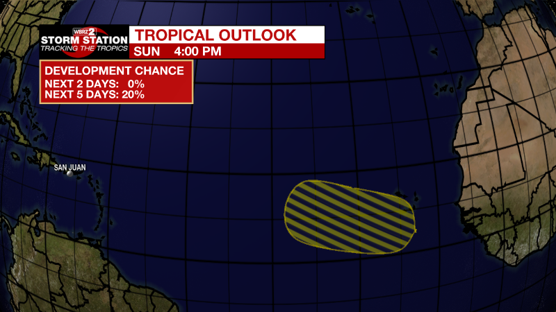
Eastern Tropical Atlantic:
A tropical wave is forecast to move off the west coast of Africa on
Monday. Any development of this wave should be slow to occur while
it moves westward or west-northwestward across the eastern tropical
Atlantic Ocean through the end of the week.
* Formation chance through 48 hours...low...near 0 percent.
* Formation chance through 5 days...low...20 percent.


