

Latest Weather Blog
Sunday Afternoon Forecast
Related Story
Radar is beginning to get active across the Capital Area, most will see a shower.
THE FORECAST
Tonight & Tomorrow: Showers and storms still popping up around the area. Some of these storms could produce gusty winds, frequent lightning, or a heavy downpour. Locally we could see some street and poor drainage flooding as a result of these showers. Radar will begin to calm down as showers fizzle off as the begins to set. Overnight we will be left with lingering clouds and humidity to start your Monday morning. Temperatures will be in the mid-70s waking up and quickly warming into the mid-90s. Monday is trending drier but not completely dry. If you have any outdoor activities, Monday would be a good day to get them done before the more rounds of rain that will be moving in later in the week.
For the next several days we are predicting rain. With several rounds of rain and not as much dry time flooding could potentially become a problem for low lying areas and roadways, or localized areas that experience a heavy downpour.
Up Next: Tuesday temperatures will peak in the low-90s and more showers and storms will be possible. Rain will mainly be in the afternoon hours and most people will see a shower. Over the next several days the rain chances increase. Wednesday and Thursday are shaping up to be total washout days with widespread showers for several hours throughout the day. These showers will keep our temperatures just below average in the high-80s across the area. Later in the week the rainy pattern begins to ease up, but we are still forecasting isolated showers. Be sure you keep your umbrella in your car this week, you will need it.
Click here to see the 7-day forecast.
Hour-by-hour weather tracking is available for your location on the WBRZ WX App on your Apple or Android device. Follow WBRZ Weather on Facebook and Twitter for even more weather updates and unique weather insight from the whole team!
In the Tropics:
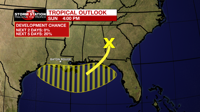
Northern Gulf of Mexico:
A surface trough of low pressure is expected to form in the northern
Gulf of Mexico, partially related to a decaying frontal boundary
currently located over the southeastern United States. Any
development of this system is expected to be slow to occur while it
drifts just offshore of the northern Gulf of Mexico coastline
through the middle to later part of this week. Regardless of
development, heavy rains will be possible along portions of the
northern Gulf coastline from Louisiana to the Florida Panhandle over
the next several days. For more information about the potential for
heavy rain, please see products issued by your local National
Weather Service office and the Weather Prediction Center.
* Formation chance through 48 hours...low...near 0 percent.
* Formation change through 5 days...low...20 percent.
News
