

Latest Weather Blog
Saturday evening video forecast
Related Story
Heat and humidity will stay in the forecast to conclude the weekend and into next week. Beryl will send tropical moisture our way early next week. This will lead to some wet weather.
Tonight & Tomorrow: Moisture is still above average this evening. This is creating some showers and thunderstorms around the area. Some stray showers are not out of the question just after dark, but these will start to dissipate as the capital area loses daytime heating. As we head into the overnight hours, skies will be partly to mostly cloudy with lows near 80 degrees.
Sunday will feature similar conditions to Saturday. Highs will be near 97 degrees under partly to mostly cloudy skies. Feels like temperatures will once again be between 105-110 degrees. Rain chances will be a tad lower than Saturday due to slightly less moisture in the area. Activity should generally stay isolated in nature.
Up Next: Early next week, rain chances will start to rise due to increased moisture from the tropics. The best day for rain looks to be Tuesday. Numerous showers and storms are likely. Rainfall could be heavy at times. Above average moisture will stick around through the end of next week. This will keep the humidity high, and also lead to the daily chance of thunderstorms. Temperature wise, highs will work their way down to the lower 90's on Tuesday because of rainfall. Highs will return back to the middle 90's by the end of the week.

The Tropics: Tropical Storm Beryl is in the west-central Gulf of Mexico. Hurricane warnings have been posted for portions of the Texas coast. As of 4pm Saturday, Beryl had 60mph winds and was moving northwest at 13mph. The storm will likely intensify to hurricane strength before a landfall in Texas Sunday night into Monday. Areas in the hurricane warning may expect storm surge along the coast, strong winds and heavy rain.
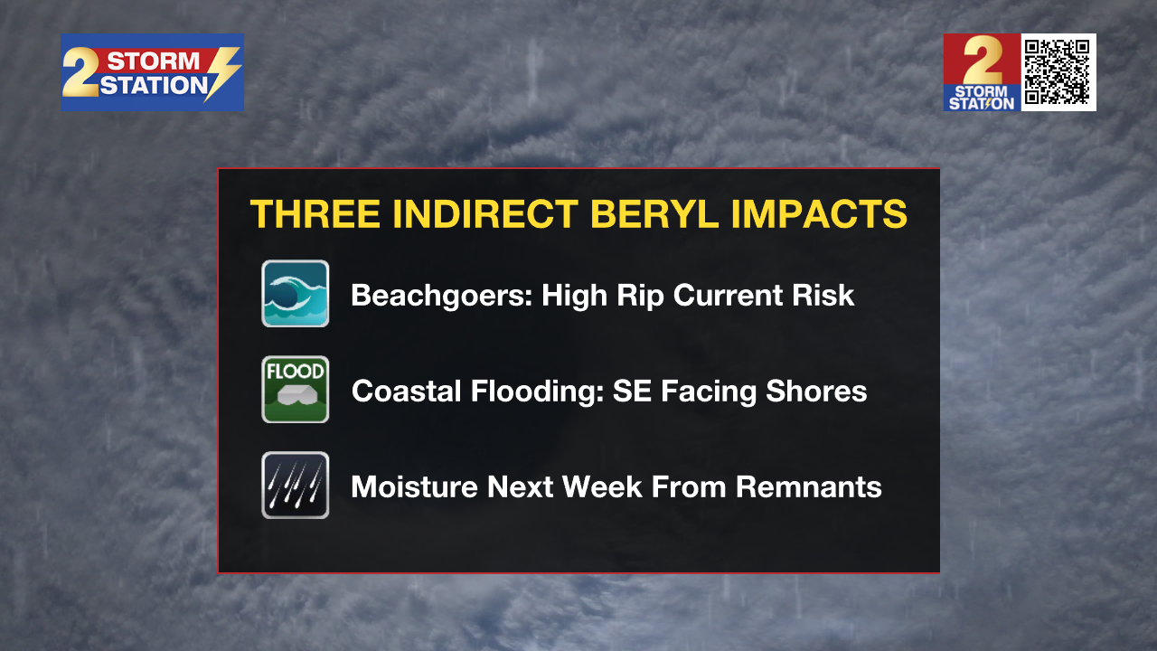
Local Impacts: Beryl will bring some indirect impacts to the local area next week. Here is a summary:
- Rip Currents—dangerous rip currents will be possible along the Louisiana Coast and for beaches as far east as the Florida Panhandle. Extreme caution should be used in areas that are permitting swimming.
- Coastal Flooding—persistent onshore winds could lead to water inundation for immediate coastal areas around the Gulf of Mexico and the tidal lakes. Tides may run a few feet above average for several days.
- Heavy Rain—remnant moisture from the storm could end up over Louisiana and Mississippi by the middle of next week. The tropical moisture could lead to heavy thunderstorms and possibly some street and poor drainage flooding.
Get the latest 7-day forecast and real time weather updates HERE.
Watch live news HERE.
– Balin
The Storm Station is here for you, on every platform. Your weather updates can be found on News 2, wbrz.com, and the WBRZ WX App on your Apple or Android device. Follow WBRZ Weather on Facebook and Twitter for even more weather updates while you are on the go.
News
