

Latest Weather Blog
Friday morning video forecast
Related Story
We have officially kicked Francine out, and much better weather conditions will follow. The next three days will be characterized by warm temperatures, lots of sunshine, and little to no rain chances.
Today & Tonight: While some areas have held on to a few clouds, these should begin to clear from west to east throughout the morning. Drier air will stay over the south, meaning rain and lots of cloud cover is unlikely for your Friday. Highs will be warm, in the upper 80's under mostly sunny skies. If heading out to see some high school football this evening, it should feel not too bad out there. Maybe warm, and slightly muggy at first, but temperatures will drop into the 70's by 9-10pm. Tonight, expect clear skies, and lows near 68 degrees.
Up Next: No complaints in the weather department for this weekend. Lots of sunshine and little to no rain chances will be good for ongoing recovery efforts and outdoor activities. Saturday may feature a little more sunshine than Sunday but both days will be quiet with just a spotty shower possible before the end of the weekend. Highs will be above average, in the low 90s and low temperatures in the upper 60s. By early next week, some isolated showers will be possible. The best, but still small, chance will be on Monday and Tuesday. There will not be any major change in temperatures next week.
Get the latest 7-day forecast and real time weather updates HERE.
Watch live news HERE.
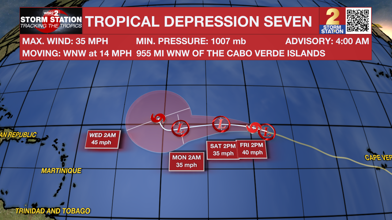
The Tropics: Tropical Depression Seven is in the far eastern Atlantic Ocean and is moving west-northwest over open waters at 14 mph. With maximum sustained winds of 35 mph, the storm is expected to be named Gordon later today, with some slow strengthening over the coming days. As of now, it poses no threat to land.
Satellite-derived wind data from several hours ago indicate that a small area of low pressure located less than one hundred miles east of the northern Leeward Islands has degenerated into a surface trough. Environmental conditions, including the proximity of dry air, do not favor development of this system while it moves west-northwestward at about 15 mph. Regardless of development, locally heavy rainfall and gusty winds are possible across the northern Leeward Islands today.
A non-tropical area of low pressure could form along a frontal boundary a few hundred miles off the southeastern U.S. coastline this weekend. Thereafter, some subtropical or tropical development is possible during the early part of next week while the system moves generally northwestward toward the coast.
– Balin
The Storm Station is here for you, on every platform. Your weather updates can be found on News 2, wbrz.com, and the WBRZ WX App on your Apple or Android device. Follow WBRZ Weather on Facebook and Twitter for even more weather updates while you are on the go.
News
