

Latest Weather Blog
Friday morning video forecast
Related Story
The active weather pattern is over and that means it is time to heat up! A "heat dome" will be with us through the weekend. This will decrease the coverage of any rain, and also increase temperatures.
Today & Tonight: We will start off the day with a lot of sunshine. This will give way to a mix of sun and clouds in the afternoon and evening. Some of these may develop into showers. Any shower will stay spotty in nature, and most will not see any rainfall. Temperatures today will be in the mid 90's. Humidity will make the feels like temperature near 105 degrees! Tonight, lows will be near 74 degrees under mostly clear skies.
Up Next: Temperatures will get even warmer as we head into the weekend. This is because of an upper level ridge of high pressure, also called “the heat dome”. This feature will also keep any rainfall spotty in nature. Both Saturday and Sunday will be in the upper 90's. Lows will be in the middle 70's. Humidity will cause feels like temperatures over 105 degrees. Keep in mind that at 107 degrees, heat advisories become necessary. Alert or not, it would be a good idea to remain hydrated and take it easy outdoors during the peak heating hours of the afternoon. The ridge will slowly break down early next week and by Tuesday, coverage in showers and thunderstorms will increase again, cutting into the duration of the heat each day.
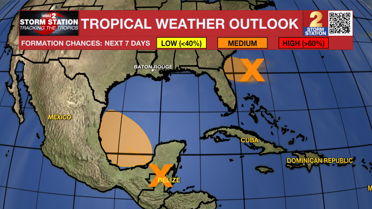
The Tropics:
A small but concentrated area of showers and thunderstorms persists with an area of low pressure located around 225 miles east of Jacksonville, Florida. However, it is unclear if the system possesses a well-defined surface circulation. Environmental conditions remain marginally conducive for some additional development, and this system could become a short-lived tropical
depression as the low moves west-northwestward at 10 to 15 mph. The system is expected to approach the northeastern coast of Florida or the Georgia coast later today, and interests there should monitor the progress of this system. An Air Force Reserve aircraft is scheduled to investigate the system later this morning, if necessary.
A broad area of low pressure is forecast to form over southeastern Mexico and northern Central America on Friday. Environmental conditions appear conducive for gradual development after this system moves over the Bay of Campeche on Saturday, and a tropical depression could form over the southwestern Gulf of Mexico this weekend while it moves slowly west-northwestward or northwestward.
Get the latest 7-day forecast and real time weather updates HERE.
Watch live news HERE.
– Balin
The Storm Station is here for you, on every platform. Your weather updates can be found on News 2, wbrz.com, and the WBRZ WX App on your Apple or Android device. Follow WBRZ Weather on Facebook and Twitter for even more weather updates while you are on the go.
News
