

Latest Weather Blog
Wednesday PM Forecast: warm nights a marker of ongoing heat
A *HEAT ADVISORY* is in effect from 11am to 7pm Thursday as feels-like temperatures up to 112 degrees are expected across the entire Storm Station Forecast Area. Hot temperatures and high humidity may cause heat illnesses. Drink plenty of fluids, and when possible, stay in an air-conditioned rooms, avoid afternoon sun, and check up on relatives and neighbors.
Tonight & Tomorrow: A spotty shower may linger into dusk but that is about it. Skies will trend clear overnight with well above average low temperatures in the low 80s. Should the temperature fail to go below 81 degrees, it will set a new record warm minimum. Thursday will be hot and steamy with high temperatures in the upper 90s and feels like temperatures ranging between 108 – 112 degrees during the peak daytime heating hours. Full sun will give way to some cumulus clouds during the afternoon; perhaps one or two could squeeze out a shower but the majority will stay dry again.
Up Next: The workweek will round out with more heat and associated alerts. Rain will be tough to find. Over the weekend, the atmosphere may cool just marginally enough to introduce a slight uptick in the number of showers and thunderstorms that can pop, but coverage will still only be isolated. Temperatures may slide by a degree or two—not much. The early expectation for next week is more of the same with big heat and low end rain coverage.
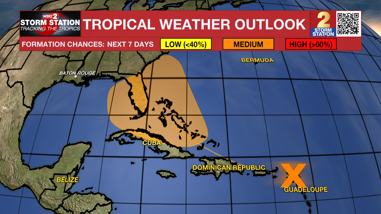
The Tropics: A large tropical wave located over the Lesser Antilles continues to produce a broad area of disorganized showers and thunderstorms. While development in the short-term is not anticipated as the system moves over portions of the Greater Antilles, environmental conditions are forecast to gradually become more conducive for development as the system moves generally west-northwestward towards the Bahamas and Cuba. There is a sixty percent chance that a tropical depression could form this weekend or early next week when the system is in the vicinity of the Greater Antilles, Bahamas, or near Florida. Interests in the Greater Antilles, the Bahamas, and the southeastern U.S. should monitor the progress of this system.
Trending News
This disturbance is not expected to impact the Capital Area. The most likely scenario is a system that remains near or east of Florida. However, it remains too early to discredit the idea that it could reach into the Gulf of Mexico. Until it gets better organized, details will be fuzzy because computer model guidance does not have something solid to initialize data.
Get the latest 7-day forecast and real time weather updates HERE.
Watch live news HERE.
– Josh
The Storm Station is here for you, on every platform. Your weather updates can be found on News 2, wbrz.com, and the WBRZ WX App on your Apple or Android device. Follow WBRZ Weather on Facebook and Twitter for even more weather updates while you are on the go.
More News
