

Latest Weather Blog
Wednesday PM Forecast: Boost in tropical moisture bringing back daily shower chances
Tropical moisture will make a comeback in the next few days, resulting in an uptick in storm activity as the workweek ends and weekend begins.
Tonight & Tomorrow: Clouds evacuate during the evening hours, leaving behind clear conditions overnight. Expect a quiet night with a low temperature in the mid to upper-60s. Tropical moisture eases in from the southeast on Thursday. The boost in moisture could allow for a spotty shower into the afternoon. All things considered, up to 20% of the area could come across measurable rain. Much of that will likely end up along and south of the interstate system where rain chances will be at their highest.
Issues for after-school activities and the afternoon drive will not be widespread. And even for those that see rain, it will be short-lived. The day will otherwise be partly sunny and unseasonably warm with a high in the low-90s.
Up Next: Moisture content improves on Friday and Saturday, leading to an increase in instability which in turn nudges the rain coverage higher. Even so, storms will be operating on an isolated to scattered basis with rain coverage on the order of about 40%. Neither Friday nor Saturday looks to be a washout and activity will generally peak during the daytime hours. With rain tapering during the evening, the weather will become more cooperative for high school football on Friday night and Southern's game versus Nicholls State on Saturday night. Rain seems to flush out of the region Sunday into Monday as a cold front draws near. That front mark another push of cooler and drier air into next week.
Get the latest 7-day forecast and real time weather updates HERE.
Trending News
Watch live news HERE.
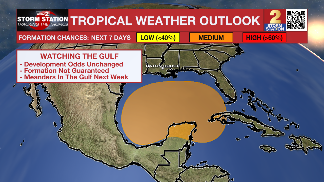
The Tropics: The Storm Station is continuing to monitor a broad area of low pressure in the northwest Caribbean Sea and southwest Gulf of Mexico. Gradual development of this system is possible into the weekend A tropical depression might form during that time as it moves fully into the Gulf of Mexico. Development odds remain unchanged at 40% from the National Hurricane Center, implying that tropical formation is far from a guarantee. At this time, tropical impacts in Louisiana are unlikely in the next seven days.
Hurricane Kirk continues to strengthen as it moves across the central Atlantic Ocean. The storm will rapidly intensify in the coming days, potentially becoming a Category 4 hurricane by Friday. Fortunately, Kirk will stay out to sea posing no threat to land.
Tropical Depression Thirteen formed on Wednesday morning. The storm is forecast to become a tropical storm by Thursday, taking the name Leslie once that happens. Over the weekend, the system could become a hurricane. The storm is trailing behind Kirk and will track in a similar fashion. As a result, this system will also pose no threat to land.
-- Meteorologist Malcolm Byron
The Storm Station is here for you, on every platform. Your weather updates can be found on News 2, wbrz.com, and the WBRZ WX App on your Apple or Android device. Follow WBRZ Weather on Facebook and Twitter for even more weather updates while you are on the go.
More News
