

Latest Weather Blog
Wednesday AM Forecast: More alerts issued as dangerous heat continues
A *HEAT ADVISORY* is in effect from 11am to 7pm Wednesday as feels-like temperatures up to 112 are expected across the entire Storm Station Forecast Area. Hot temperatures and high humidity may cause heat illnesses. Drink plenty of fluids, and when possible, stay in an air-conditioned rooms, avoid afternoon sun, and check up on relatives and neighbors.
Today & Tonight: Wednesday morning will begin hot and steamy with temperatures struggling to drop below 80° in some parishes. With plenty of moisture in the atmosphere, patchy areas of fog may develop during the early Wednesday morning commute, especially along bodies of water. Once the sun rises, any low visibility issues will be eliminated and replaced by hot and humid conditions. Heat index values are likely to hit triple digits during the mid-morning hours and stay there all day long, peaking between 108 - 112 degrees. Actual temperatures will reside in the upper-90's this afternoon. Cumulus clouds are likely to create partly sunny skies Wednesday afternoon and while most will stay dry, one or two might squeeze out a quick shower. Tonight, temperatures in the Capital City will slowly retreat near 80° under clear skies.
Up Next: The extreme heat will persist as we welcome August on Thursday. Afternoon highs to end the workweek will remain in the upper-90's, so it is likely that more heat alerts will be issued. Saturday and Sunday feature the same partly sunny skies and warm mornings but afternoon temperatures may be a few degrees "cooler", in the middle-90's with a slightly better opportunity to run into a rain shower. Both days feature a 30% coverage chance for isolated t-storms, still most will remain dry. The high heat looks to continue into the next workweek as well.
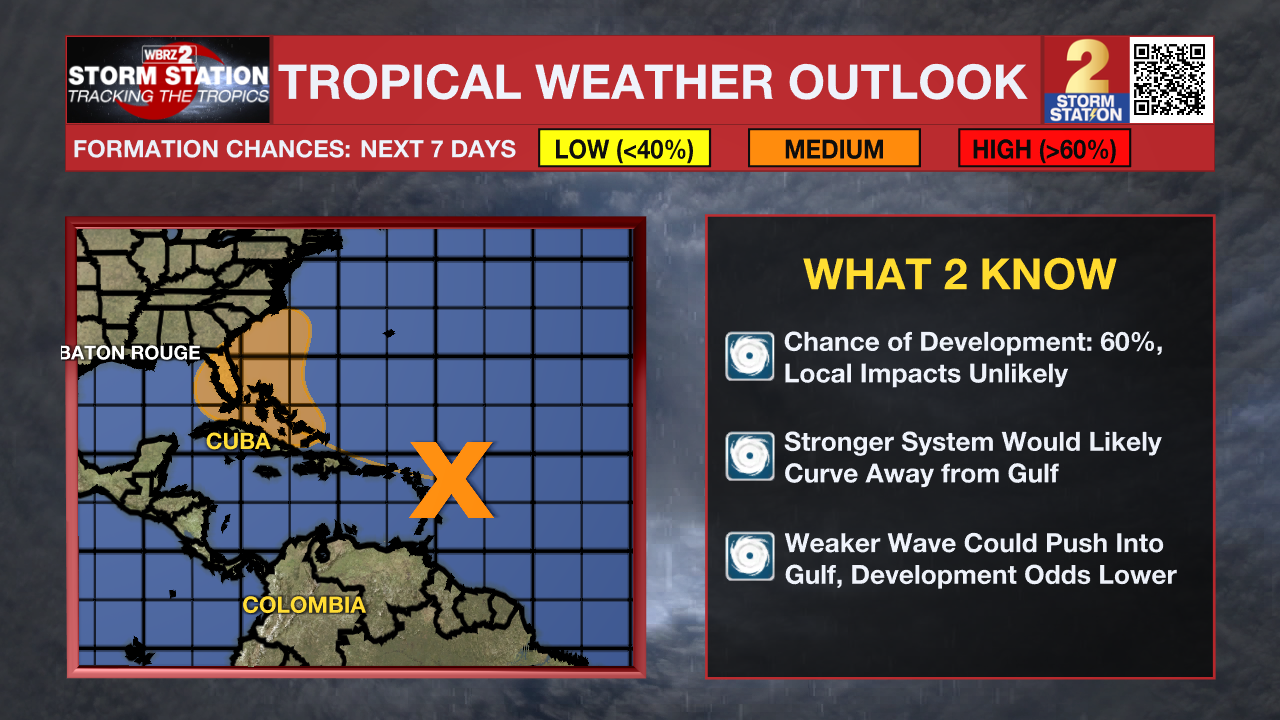
The Tropics: A large tropical wave in the Atlantic, centered several hundred miles east of the Lesser Antilles, is producing limited shower activity due to environmental dry air. Conditions are forecast to become a little more conducive for development over the warmer waters of the southwestern Atlantic Ocean, and a there is a medium chance that a tropical depression could form late this week while the system is in the vicinity of the Greater Antilles or the Bahamas. Interests in the Greater Antilles, the Bahamas, and the southeastern U.S. should monitor the progress of this system.
Trending News
Get the latest 7-day forecast and real time weather updates HERE.
Watch live news HERE.
– Emma Kate C.
The Storm Station is here for you, on every platform. Your weather updates can be found on News 2, wbrz.com, and the WBRZ WX App on your Apple or Android device. Follow WBRZ Weather on Facebook and Twitter for even more weather updates while you are on the go.
More News
