

Latest Weather Blog
UPDATE: Flood Watch remains in effect as heavy rain arrives in capital area
The National Weather Service has issued a FLOOD WATCH for southern Louisiana through Friday evening for Baton Rouge and points south. Excessive runoff may result in flooding of rivers, creeks, streams, and other low-lying and flood-prone locations. Flooding may occur in poor drainage and urban areas. Be sure to monitor future forecasts and remain alert for possible Flash Flood Warnings. Those living in areas prone to flooding should be prepared to take action should flooding develop. About 2-4 inches of rain is expected in the watch area, though isolated higher amounts are possible - especially closer to the coast.
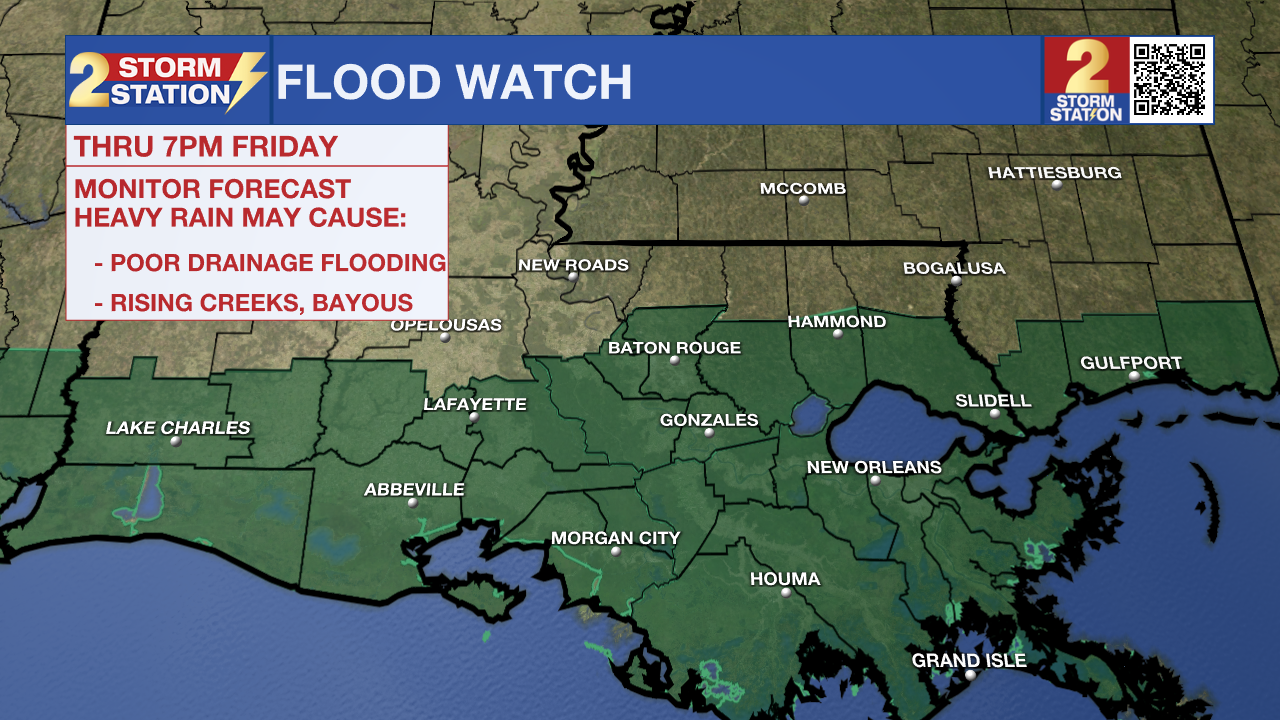
Deep Gulf moisture has begun to move over the region as of 1 p.m. Wednesday, allowing for scattered shower and storm development. Expect this activity to continue and perhaps become even more widespread into Thursday and Friday. Downpours leading to high rain rates raise the concern for isolated standing water concerns across southern Louisiana through Friday evening. Make sure to stay weather aware in the coming days and turn weather alerts on.
Today & Tonight: As of Wednesday afternoon, clouds have filled in skies across the region. Scattered showers have also begun to move into the capital region from coastal waters. Scattered showers and thunderstorms will continue through Wednesday afternoon and evening with roughly 80% of the area seeing measurable rainfall. The rain has already left behind cooler weather. Afternoon temperatures will likely remain in the 70s and 80s for most. The rain will become more widely scattered in coverage on Wednesday night. Look for an overnight low near 75°.
Late Week: Thursday and Friday will be cloudy and stormy. A weak front lingering over the state mixed with above average moisture amounts in the atmosphere will motivate widespread showers and storms both days. Rain could be heavy at times, creating low visibility and nuisance standing water on roadways during commutes beginning Wednesday afternoon through Friday evening. The latest data suggest that rain will dwindle as dry air pushes in late Friday night. Exact timing does remain tricky so those with plans to attend Friday night football games should stay in-touch with the forecast over the next several days as more data comes in.
This Weekend: Once the front pushes through the area from north to south late Friday night, the thick moisture will be pushed away from the region. This will be felt in the form of much lower humidity and noticed by skies clearing into the weekend. A reinforcing shot of dry air on Saturday is likely to bring the driest and coolest air felt since early June. We might be able to classify that incoming air mass as the first taste of fall this season.
Trending News
Get the latest 7-day forecast and real time weather updates HERE.
Watch live news HERE.
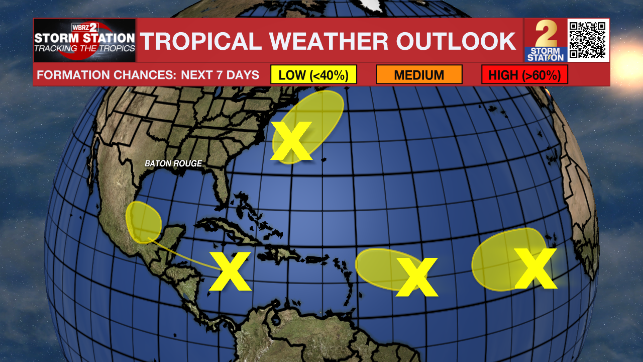
The Tropics: There are several areas of interest in the Atlantic Basin, all of which have low chances of tropical development in the next week.
A tropical wave moving quickly westward at about 20 mph is producing a broad area of thunderstorms across the central Caribbean Sea. Some development is possible into next week as the system emerges over the southwestern Gulf of Mexico. This wave poses no immediate cause for concern locally, but it is worth keeping an eye on this disturbance in the long-term.
A non-tropical area of low pressure located a few hundred miles east of North Carolina might acquire some subtropical characteristics over the next few days as it moves northeastward. Fortunately, the system will remain offshore and does not appear to be a big threat to land at this time.
Another tropical wave located over the eastern tropical Atlantic remains disorganized. Slow development of this system is possible in the coming days as it drifts northwestward.
An additional tropical wave is located farther to the west in the central tropical Atlantic. This wave also remains disorganized. Slow development is possible in the next few days. However, conditions will become less favorable for development by the end of the week.
– Emma Kate C., Malcolm Byron
The Storm Station is here for you, on every platform. Your weather updates can be found on News 2, wbrz.com, and the WBRZ WX App on your Apple or Android device. Follow WBRZ Weather on Facebook and Twitter for even more weather updates while you are on the go.
More News
