

Latest Weather Blog
Wednesday AM Forecast: Dry today, Rain coverage increases to end the week
The mid-week forecast remains dry but returning moisture into the region on Thursday will support isolated showers and storms Friday and Saturday.
Today & Tonight: Early Wednesday, mainly clear skies and temperatures in the mid to upper-60s will continue the trend of mild mornings this week. This afternoon will also be a lot like the past few, with plenty of sunshine, dry conditions, and temperatures in the low 90s. Winds today will be out of the northeast around 5-10 mph. Overnight, temperatures will again fall into the upper 60s in the Capital Area.
Up Next: Thursday marks the slight shift in weather pattern as moisture begins to return to the atmosphere from the Gulf. Increasing moisture will bring a few more clouds and a spotty shower or two Thursday but bigger impacts over the weekend. Both Friday and Saturday will see mostly cloudy skies and isolated showers and storms around. While the two days hold the best chance of rain over the next week, only around 40% of the Storm Station forecast area will see rain each day, meaning not everyone will be lucky enough for a free yard watering. Temperatures Friday and Saturday will be a few degrees cooler with the added clouds, likely to only top out in the mid to upper 80s each afternoon.
By Sunday and Monday, warm and steamy conditions will return ahead of a cold front that is set to arrive early next week. Latest data suggest timing of the front's arrival will be Monday into Tuesday, with the cooler temperatures felt as early as Tuesday afternoon. As we get closer to next week, the Storm Station will have a better idea of how cool conditions may get behind the front.
Get the latest 7-day forecast and real time weather updates HERE.
Trending News
Watch live news HERE.
The Tropics: Now Hurricane Kirk continues to strengthen across the central Atlantic Ocean. Kirk is moving northwest at 14mph, with winds of 80mph. This system is forecast to become a major hurricane later this week. Fortunately, a continued track towards the north/northwest will keep Kirk out to sea where it will not pose a threat to the United States.
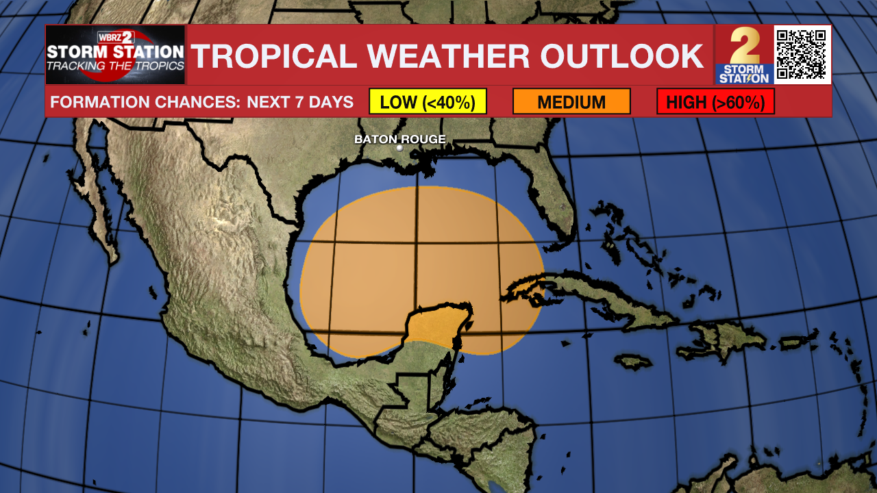
A broad trough of low pressure is producing a large area of disorganized showers and thunderstorms from the southwestern
Caribbean Sea into the southern Gulf of Mexico. Environmental conditions could support some gradual development of this system, and a tropical depression could form over the weekend as the broader disturbance moves fully into the Gulf of Mexico. Interests along the U.S. Gulf Coast should continue to monitor the progress of this
Showers and thunderstorms continue to show signs of organization in association with an area of low pressure located a few hundred miles south-southwest of the Cabo Verde Islands. Environmental conditions appear conducive for further development of this system, and a tropical depression is expected to form during the next day or so while it moves slowly westward over the eastern tropical Atlantic.
– Emma Kate C.
The Storm Station is here for you, on every platform. Your weather updates can be found on News 2, wbrz.com, and the WBRZ WX App on your Apple or Android device. Follow WBRZ Weather on Facebook and Twitter for even more weather updates while you are on the go.
More News
