

Latest Weather Blog
Tuesday PM Forecast: searing back to school weather continues
A * HEAT ADVISORY* is in effect from 10am to 7pm Wednesday as feels-like temperatures over 108 degrees are expected across the entire Storm Station Forecast Area. Hot temperatures and high humidity may cause heat illnesses. Drink plenty of fluids, and when possible, stay in an air-conditioned rooms, avoid afternoon sun, and check up on relatives and neighbors.
Tonight & Tomorrow: Skies will go all clear overnight with well above average low temperatures continuing. Most locations should slip just below 80 degrees. Wednesday will be sweltering hot once again. Widespread high temperatures over 100 degrees are anticipated. After full sun to start, skies will be mostly sunny through much of the afternoon.
Up Next: The rest of the week will feature a continuation of the hot and dry pattern. Afternoon high temperatures will likely reach the century mark through Friday. In doing so, 2024 will climb the charts as one of the hottest summers on record and, specifically, crack the top five for most 100 degree days in a year.
While the humidity might be a touch lower, it will still be high enough to produce dangerous feels-like temperatures over 108 degrees during the peak heating hours. Expect ongoing heat alerts. Especially with kids heading back to the classroom, hydration will be key for any outdoor after school activities. Rain is scarce on the Storm Station 7-Day Forecast. Most will not pick up any meaningful rainfall through the weekend.
Trending News
The Tropics: Tropical Storm Debby continued to churn and dump heavy rain over portions of the Florida, Georgia, North Carolina and South Carolina. As of 4pm Tuesday, Debby had maximum sustained winds of 40mph and was drifting east at 3mph. Debby will move offshore Tuesday night and strengthen a little before a second landfall in the Carolinas later this week. Debby is expected to produce potentially historic rainfall totals of 10 to 20 inches, with maximum amounts of 25 inches, bringing areas of catastrophic flooding across portions of the eastern half of South Carolina, and southeast North Carolina through Friday.
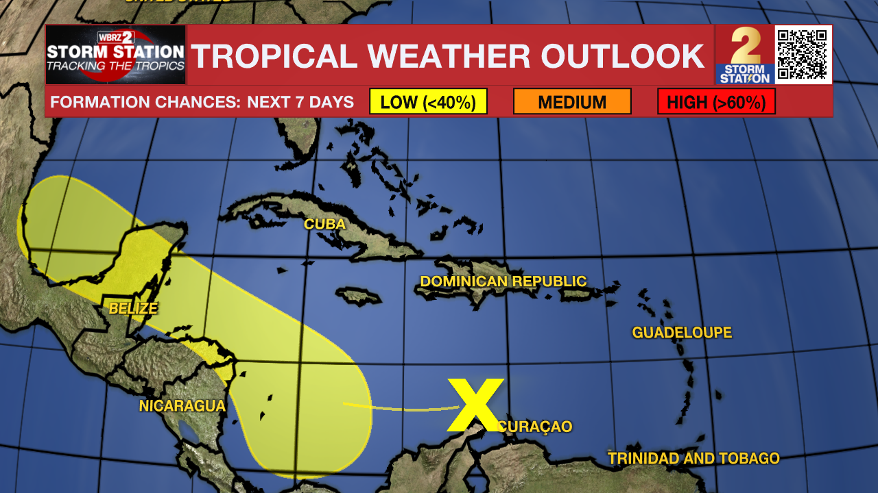
Showers and thunderstorms associated with a tropical wave located over the east-central Caribbean Sea have diminished in coverage and intensity since this morning. Any development of this system should be slow to occur during the next couple of days while it moves westward over the central Caribbean Sea. Environmental conditions are expected to become more conducive for development later this week as the system moves across the western Caribbean Sea or the southern Gulf of Mexico.
Get the latest 7-day forecast and real time weather updates HERE.
Watch live news HERE.
– Josh
The Storm Station is here for you, on every platform. Your weather updates can be found on News 2, wbrz.com, and the WBRZ WX App on your Apple or Android device. Follow WBRZ Weather on Facebook and Twitter for even more weather updates while you are on the go.
More News
