

Latest Weather Blog
Tuesday PM Forecast: ridge in control, heat to persist
A *HEAT ADVISORY* is in effect from 11am to 7pm Wednesday as feels-like temperatures up to 112 are expected across the entire Storm Station Forecast Area. Hot temperatures and high humidity may cause heat illnesses. Drink plenty of fluids, and when possible, stay in an air-conditioned rooms, avoid afternoon sun, and check up on relatives and neighbors.
Tonight & Tomorrow: The few brief showers the developed on Tuesday will quickly dissipate after nightfall. Beneath mainly clear skies, low temperatures will struggle to leave the 80s. Wednesday will be hot and steamy with high temperatures in the upper 90s and feels like temperatures ranging between 108 – 112 degrees during the peak daytime heating hours. Full sun will give way to some cumulus clouds during the afternoon; perhaps one or two could squeeze out a shower but the majority will stay dry again.
Up Next: Heat will remain a common theme through the rest of the week with highs reaching the upper-90s every day. Combined with high humidity, daily heat alerts will likely be needed. These will indicate potential of the heat index stretching to 108 degrees or higher, likely for several hours each afternoon. Rain will be tough to find, with spotty showers and thunderstorms, at best. Over the weekend, the atmosphere may cool just marginally enough to introduce a slight uptick in the number of showers and thunderstorms that can pop, but coverage will still only be isolated. Temperatures may slide by a degree or two—not much.
Trending News
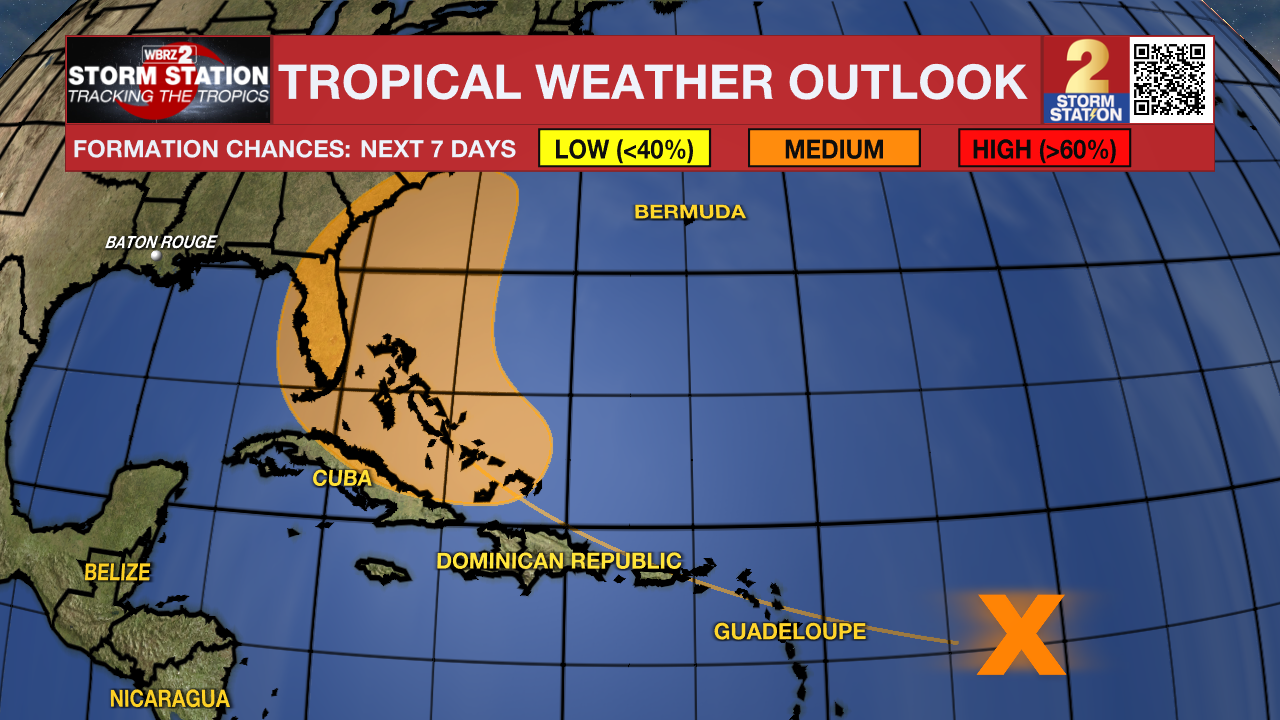
The Tropics: A large tropical wave centered several hundred miles east of the Lesser Antilles is producing limited shower activity due to environmental dry air. Conditions are forecast to become a little more conducive for development over the warmer waters of the southwestern Atlantic Ocean, and a there is a medium chance that a tropical depression could form late this week while the system is in the vicinity of the Greater Antilles or the Bahamas. Interests in the Greater Antilles, the Bahamas, and the southeastern U.S. should monitor the progress of this system.
Get the latest 7-day forecast and real time weather updates HERE.
Watch live news HERE.
– Josh
The Storm Station is here for you, on every platform. Your weather updates can be found on News 2, wbrz.com, and the WBRZ WX App on your Apple or Android device. Follow WBRZ Weather on Facebook and Twitter for even more weather updates while you are on the go.
More News
