Tuesday AM Forecast: Tracking midweek storms followed by slight cool down
The refreshing break from humidity Tuesday will be short lived as a surge of Gulf moisture returns and encourages rain chances Wednesday. Another cold front will arrive behind the rain, bringing dry air and slightly cooler temperatures into the weekend.
Today & Tonight: Behind a weak front, Tuesday morning lows will cool the lowest they have in many days. Early morning conditions will start near 60 degrees for most, under clear skies and paired with a light northerly breeze. A lack of humidity today will make the afternoon high in the low 80s much more comfortable than in previous days. Skies will start off clear but gradually increase in cloud cover as the day wears on. A few sprinkles will be possible also. Tonight, a surge of Gulf moisture into the region means a return of the mugginess, cloudy skies, temperatures in the 70s and even a rain shower or two.
The Next Impact: With ample amounts of moisture back in the air paired with an upper-level disturbance approaching the region from the west, many showers and storms will return to the Capital Region Wednesday. Coverage will start off spotty to isolated during the early morning commute and gradually increase throughout the day. Scattered thunderstorms are likely to be around the Capital Area Wednesday afternoon and into the early evening hours. A few storms might repeat, or train, over the same location producing localized instances of nuisance flooding or standing water. A rogue strong to borderline severe storm isn't out of the question either with gusty winds being the primary threat. With storm activity likely during the later afternoon hours, weather impacts to your evening commute are not out of the question. Those with children that have outdoor afterschool activities should also monitor the forecast closely.
The Front That Follows: Late Wednesday, a cold front will approach and eventually push through the region early Thursday morning. This will end rain chances from west to east. A cooler and less humid air mass will trail said front. Highs will dip into the upper 70s with lows down into the 50s through the weekend. Although relatively cooler, even these temperatures are above the averages for this time of year. The wait continues for a significant blast of cooler air.
Get the latest 7-day forecast and real time weather updates HERE.
Trending News
Watch live news HERE.

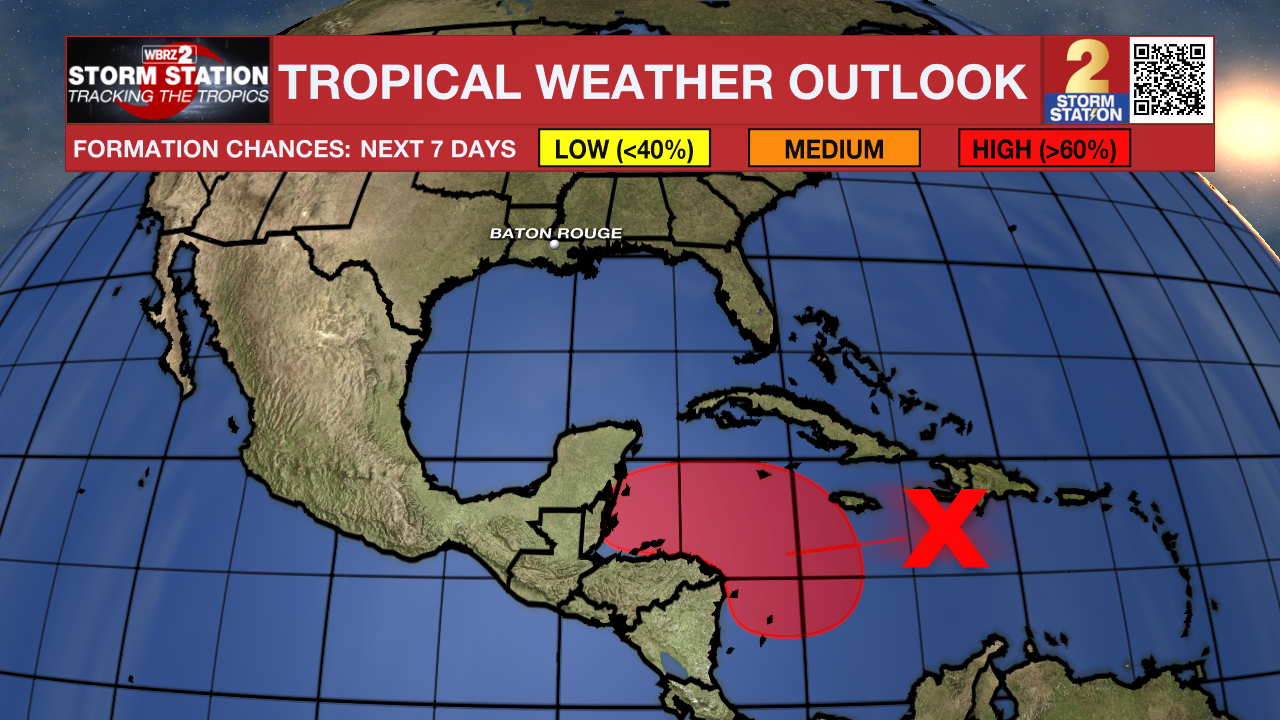
The Tropics: There are currently no active storms in the Atlantic Basin but the NHC has highlighted a tropical wave over the central Caribbean Sea that is producing an area of disorganized showers and thunderstorms. Environmental conditions appear conducive for development, and a tropical depression is likely to form by the end of the week as the system moves slowly westward into the western Caribbean Sea. Afterward, the disturbance is expected to meander over the weekend and begin moving slowly, generally northwestward, by early next week. Interests across the western Caribbean Sea should monitor the progress of this system. For now, this system does not appear to pose a threat to Louisiana.
- Emma Kate C.
The Storm Station is here for you, on every platform. Your weather updates can be found on News 2, wbrz.com, and the WBRZ WX App on your Apple or Android device. Follow WBRZ Weather on Facebook and X for even more weather updates while you are on the go.


