

Latest Weather Blog
Tuesday AM Forecast: Surge of gulf moisture brings even more rain to the region
A surge of gulf moisture will motivate even more shower and storm activity throughout the next several days. Heavy downpours within storms could make for several messy commutes.
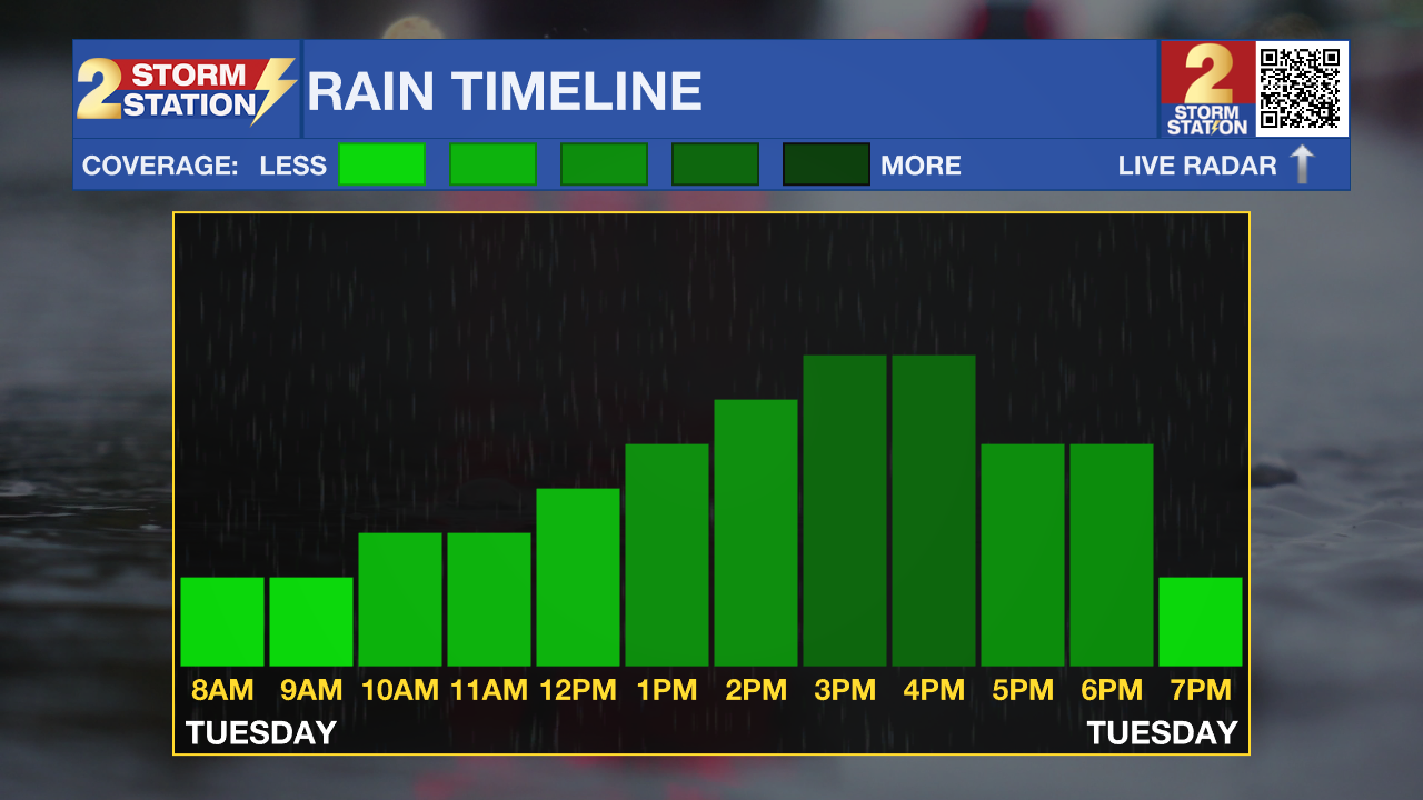
Today & Tonight: While early Tuesday morning conditions will be mostly dry, prepare for yet another wet day in southern Louisiana. Shower and storm activity popping off the coast of Louisiana early Wednesday will move towards the region during the morning hours, eventually arriving and bringing scattered to numerous storms to the area. Most of the widespread rain will stay to our west, but 90% of the WBRZ coverage area is forecast to see rain at some point on Tuesday. While spotty storms may develop before noon, the morning hours will mainly be cloudy and muggy with temperatures in the 80's. Post-lunchtime, rain coverage will increase as waves of storms move across the Capital Area. Within any of the storms today, heavier downpours and gusty winds are possible which could lead to nuisance street flooding and localized areas of flash flooding. The evening commute could be a messy one, so use caution when hitting the roadways.
Tuesday night will catch a break from the rain before another possible round of storms arrives early Wednesday morning.
Up Next: A continued surge of gulf moisture keeps even more rain in the forecast through the end of the week. Wednesday will be another very soggy day, with rain arriving as early as before sunrise and continuing on and off throughout the day. There will be periods of dry time but cloudy skies will keep temperatures near 87° during peak heating hours. Thursday features a rain coverage of 70% with mostly cloudy skies as we begin to transition out of the extremely unsettled pattern. Over the weekend, while we cannot rule out scattered activity each day, we will begin to return the typical summertime behavior, with partly sunny conditions and afternoon temperatures in the low-90s. Around 1-3 more inches of rainfall could accumulate by the end of the week.
Trending News
The Tropics: The North Atlantic Ocean, Caribbean Sea and Gulf of Mexico are quiet. No development is expected over the next seven days.
Get the latest 7-day forecast and real time weather updates HERE.
Watch live news HERE.
– Emma Kate C.
The Storm Station is here for you, on every platform. Your weather updates can be found on News 2, wbrz.com, and the WBRZ WX App on your Apple or Android device. Follow WBRZ Weather on Facebook and Twitter for even more weather updates while you are on the go.
More News
