

Latest Weather Blog
Tuesday AM Forecast: Air Quality and Heat Alerts issued as oppressive heat continues
If you're searching for any relief from the oppressive summertime heat and humidity this week, it will not be found in southern Louisiana. The first heat alert of the week as been issued with many more likely over the next 7 days.
A *HEAT ADVISORY* is in effect from 10am to 7pm Tuesday as feels-like temperatures up to 112° are expected across the entire Storm Station Forecast Area. Hot temperatures and high humidity may cause heat illnesses. Drink plenty of fluids, and when possible, stay in an air-conditioned rooms, avoid afternoon sun, and check up on relatives and neighbors.
An *AIR QUALITY ALERT* will be in effect from 6am Tuesday through midnight. The Louisiana Department of Environmental Quality is forecasting an Ozone Advisory Day for East Baton Rouge, West Baton Rouge, Livingston, Ascension, Iberville, and Pointe Coupee Parishes for the rest of today and again on Tuesday. The Air Quality Index indicates that ozone will be at the Orange level, which is unhealthy for sensitive groups. Increasing ozone levels may cause unhealthy air quality during afternoon hours. Active children and adults, the elderly, and people with respiratory
diseases such as asthma should avoid prolonged outdoor exertion. Please take whatever voluntary steps you can to reduce emissions that contribute to ozone formation. Drive less and make sure your automobile is in good working condition. Make sure your gas cap is tight. Wait until after 6 PM to refuel your vehicle and use gas powered lawn equipment.
Today & Tonight: Early Tuesday morning lows will barely dip into the 70's before ample amounts of morning sunshine begin to heat temperatures back up. Highs today will reach into the upper-90's with excessive heat index values thanks to an uptick in humidity. The summer sizzle could feel as hot as 112° at times Tuesday afternoon. Similar to Monday, any rain activity Tuesday afternoon will be very spotty in nature and only a lucky few will run into a cool down shower. The best coverage of showers and storms will reside along the coast on Tuesday. Overnight, mainly clear and muggy conditions will see temperatures drop near 79° in Baton Rouge.
Up Next: The Capital Region will be stuck in a cycle of warm, muggy mornings and hot and humid afternoons through at least the next 7-days. Heat alerts will become very common again as there seems to be no relief from the oppressive temperatures in the near feature. Rain showers will remain on a pop-up basis each afternoon.
Trending News
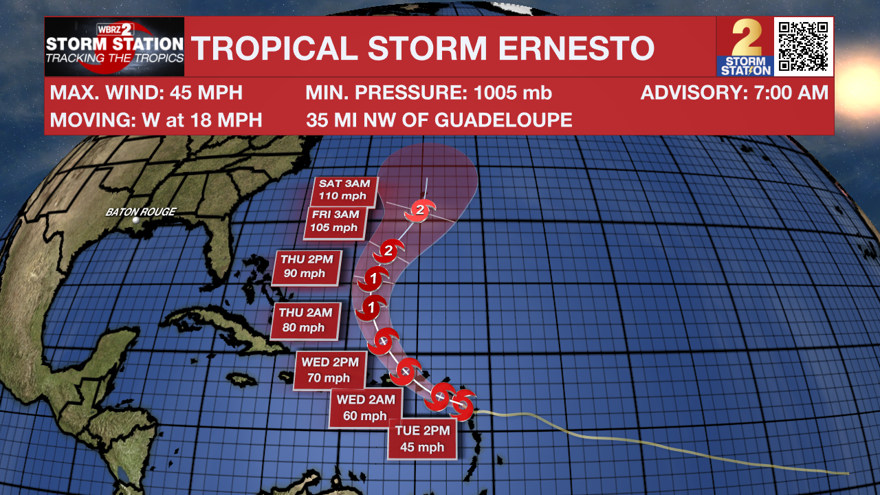
The Tropics: Early Tuesday morning, Tropical Storm Ernesto will approach the Leeward Islands and then take aim at Puerto Rico. Afterward, the system will curve out to sea while strengthening and could become a major hurricane. The Storm Station does not anticipate any impacts in Louisiana at this time. For that matter, direct impacts to the continental United States are unlikely.
Get the latest 7-day forecast and real time weather updates HERE.
Watch live news HERE.
- Emma Kate C.
The Storm Station is here for you, on every platform. Your weather updates can be found on News 2, wbrz.com, and the WBRZ WX App on your Apple or Android device. Follow WBRZ Weather on Facebook and Twitter for even more weather updates while you are on the go.
More News
