

Latest Weather Blog
Tornado Watch in effect for the Baton Rouge area Wednesday
UPDATE: The Tornado Warning and Flash Flood Warning are no longer in effect for the capital area.
A Tornado Watch remains in effect for the entire WBRZ viewing area through 8 p.m. Wednesday.
------
A strong cold front will move through the region on Wednesday. Ahead of and along the front, there will be a potential for severe thunderstorms and heavy rain. Much colder temperatures will follow.
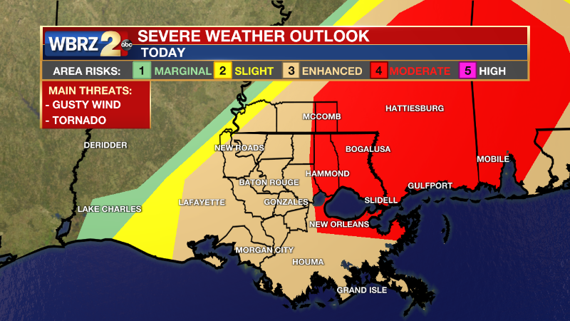
UPDATE: The eastern most part of the WBRZ viewing area now upgraded to a Level 4/5 Moderate risk of seeing severe weather. Parishes included are Tangipahoa, and New Orleans metro area are now included in the moderate risk. The main threats are for flash flooding and the possibility of strong tornadoes with winds upwards of 75 mph.
NEW (5:55am Wednesday) -- The National Weather Service has issued a TORNADO WATCH for the entire WBRZ viewing area until 1pm this afternoon.
Trending News
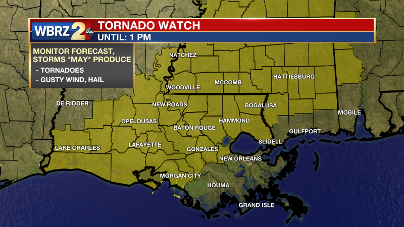
A TORNADO WATCH means conditions are favorable for tornadoes and/or damaging winds in and around the watch area. Be on the lookout for threatening weather conditions and listen for later statements and possible warnings.
NEW (5:32am Wednesday) -- The National Weather Service has issued a FLASH FLOOD WARNING for northwestern Pointe Coupee parish, northwestern West Feliciana parish, and Wilkson county. EXTENDED until 10:45 am.
***FLASH FLOOD WARNING*** for the highlighted area. Roads may be flooded, turn around don't drown! #lawx #mswx Our latest forecast: https://t.co/1NFYtqf6dL pic.twitter.com/H7O1VfsNV2
— WBRZ Weather (@WBRZweather) December 14, 2022
A slow-moving line of thunderstorms will sag southeast through daybreak. Individual storm cells (those that become supercells) ahead of this line will pose the greatest threat for tornadoes. In and around the watch area, a couple intense tornadoes will be possible in addition to isolated, significant gusts up to 75mph.
Click HERE to watch WBRZ streaming live online
Click HERE for the WBRZ weather page.
Click HERE to see how to download the WBRZ weather app.
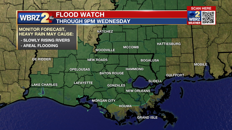
WEDNESDAY: A line of rain and thunderstorms is expected to reach parishes and counties north and west of Baton Rouge near dawn. At that time, the line will slow down and intensify and so a FLOOD WATCH is in effect until the heavy rain exits later in the afternoon. While isolated tornadoes and strong wind will be possible ahead of the line, the biggest issue will likely become heavy rain. Repeated downpours could lead 3 to 5 inches in some places which could cause street and poor drainage flooding as well as rapid rises on the smaller creeks and streams. Temperatures will be steady in the low to mid 70s until the cold front passes during the afternoon and evening.
WHAT 2 KNOW:
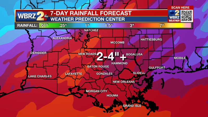
-HEAVY RAIN - slow moving storms could dump 3-5 inches in a few hours, street, poor drainage and creek flooding possible
-SEVERE WEATHER - possible through Wednesday afternoon
-HOLIDAY DECORATIONS - lightweight and vulnerable to gusty wind, strongly secure or move them before storms
-BE WEATHER AWARE - have a way to receive weather alerts, know the safest place to go during warning
SAFETY: Make sure you have a way to receive warnings in the event storms in your area turn severe. You can download or activate the WBRZ WX App on your Apple or Android device or turn on a NOAA Weather Radio for bulletins such as watches and urgent warnings. If a tornado warning or severe thunderstorm warning is issued, seek shelter in a low-level, interior room of a sturdy building. Take pets (on a leash) with you, have on hard-soled shoes, monitor storm coverage on a wireless device and cover your head in the event of wind or tornado impact. If a flash flood warning is issued, do not drive on flooded roads and avoid low lying areas. For more on severe weather safety, CLICK HERE.
Up Next: Thursday and Friday will return below average temperatures for the first time in almost two weeks. Beneath mainly clear skies, high temperatures will be in the upper 50s to low 60s with low temperatures in the upper 30s and low 40s. A few clouds will return over the weekend. By Monday, rain will return to the forecast. Overall, this does appear to be the beginning of a large scale pattern change which will keep warmer temperatures out of the area for a long period of time. CLICK HERE for your detailed 7-Day Forecast.
The Storm Station is here for you, on every platform. Your weather updates can be found on News 2, wbrz.com, and the WBRZ WX App on your Apple or Android device. Follow WBRZ Weather on Facebook and Twitter for even more weather updates while you are on the go.
More News
