

Latest Weather Blog
Thursday PM Forecast: some could see aurora on a clear night, stronger cold front ahead
The run of cool mornings and warm afternoons will continue thanks to a very dry air mass in place across the Capital Area. Outdoor plans should be picture perfect through the weekend.
Tonight & Tomorrow: Clear skies will continue overnight with low temperatures in the low 60s. Friday will present full sunshine with high temperatures in the low 90s. It should be a relatively comfortable warmth in the absence of humidity. Thermometers will settle through the 80s and then 70s for high school football.
Another Aurora Sighting: NOAA's Space Weather Prediction Center (SWPC) has observed severe geomagnetic storm activity as of Thursday afternoon. This is the result of a coronal mass ejection (from the sun) that reached the Earth shortly beforehand. If these conditions can persist past dark, the Northern Lights might be visible overhead near the US-Canadian border, and on the low horizon as far south as Alabama. But these forecasts can be real tricky. If the geomagnetic storm outperforms and reaches "extreme" levels, a faint glow cannot be ruled out as far south as the Gulf Coast. But know this is not guaranteed.
The best viewing times according to the SWPC will be begin after sunset and last until 1 a.m. CDT. The geomagnetic activity will ease with time through the rest of the night. In south Louisiana, it is unlikely that anything will be visible to the naked eye. In the northern part of the state and away from city light pollution, with a long exposure camera, there is an outside chance of seeing a faint green or purple glow on the horizon. And that is if activity is strong enough to make it this far south.
Trending News
Along the Canadian border the so-called Northern Lights will be visible to the naked eye. There is even a chance of catching a glimpse as far south as Washington D.C. westward to San Francisco.
Regardless, nobody should expect to see dancing ribbons of green and purple as publicized in online photos and videos - especially locally. At best, the sight would be similar to what was seen a few months ago in the capital area.
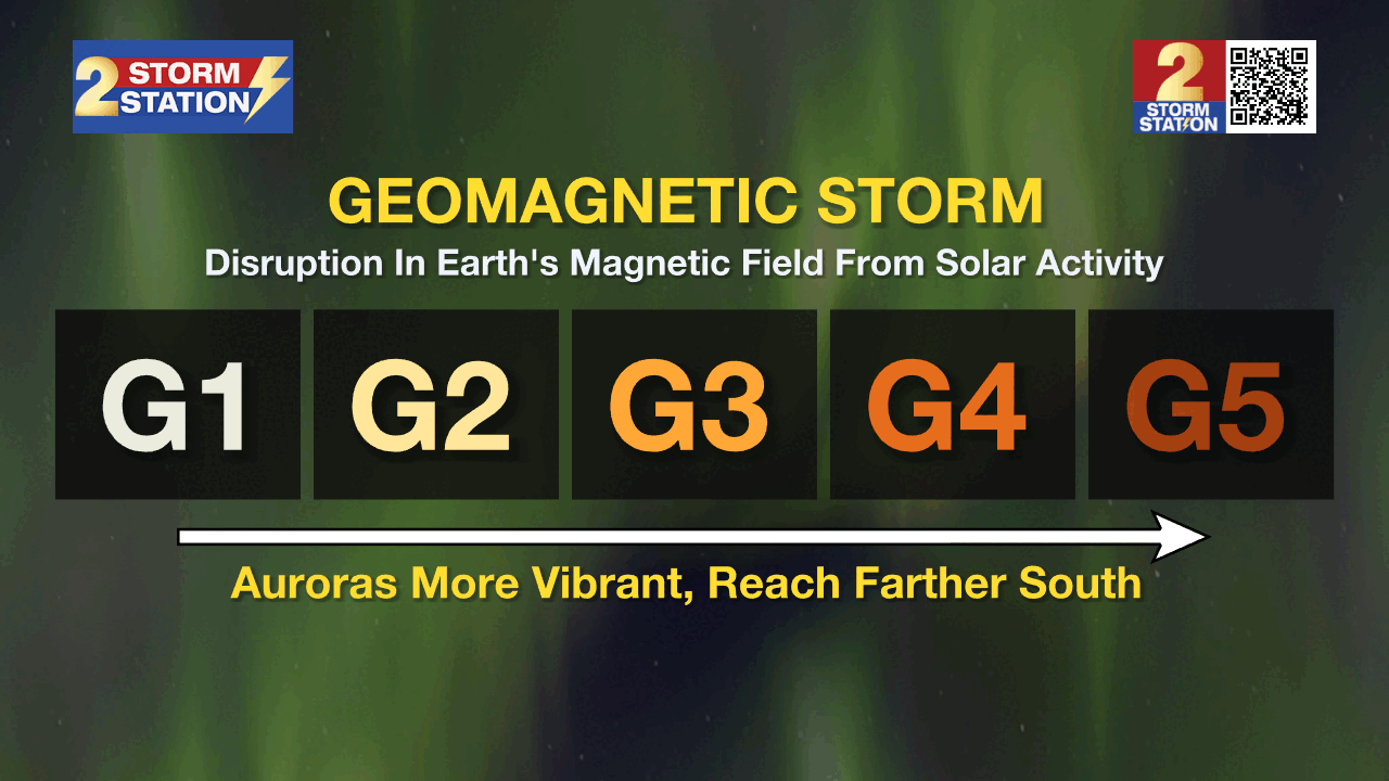
A geomagnetic storm is a disruption in the Earth's magnetic field caused by solar activity. Specifically in this instance, the auroral light display would be caused by a coronal mass ejection which occurred on Tuesday afternoon. Think of this like a solar "burp" of super-hot, super-energized gas threaded by magnetic fields. If these hit Earth, that's when the aurora borealis becomes more vibrant and shifts south to areas not accustomed to seeing the spectacle.
The latest coronal mass ejection was captured in the following image. Look for the powerful burst of solar material directed away from the center of the image. Also making a cameo in the shot is C/2023 A3 (Tsuchinshan-ATLAS), which will be visible in capital area skies next week.
Severe geomagnetic storms can also cause disruptions to satellite communications and navigation systems, terrestrial-based radio, and even the power grid. However, most know the visual result of such a storm known as the aurora.
For additional solar activity and forecasts, visit the SWPC site. When you see weather (or space) happening, share it with us! Email photos to weather@wbrz.com or submit them via the Storm Station Weather App.
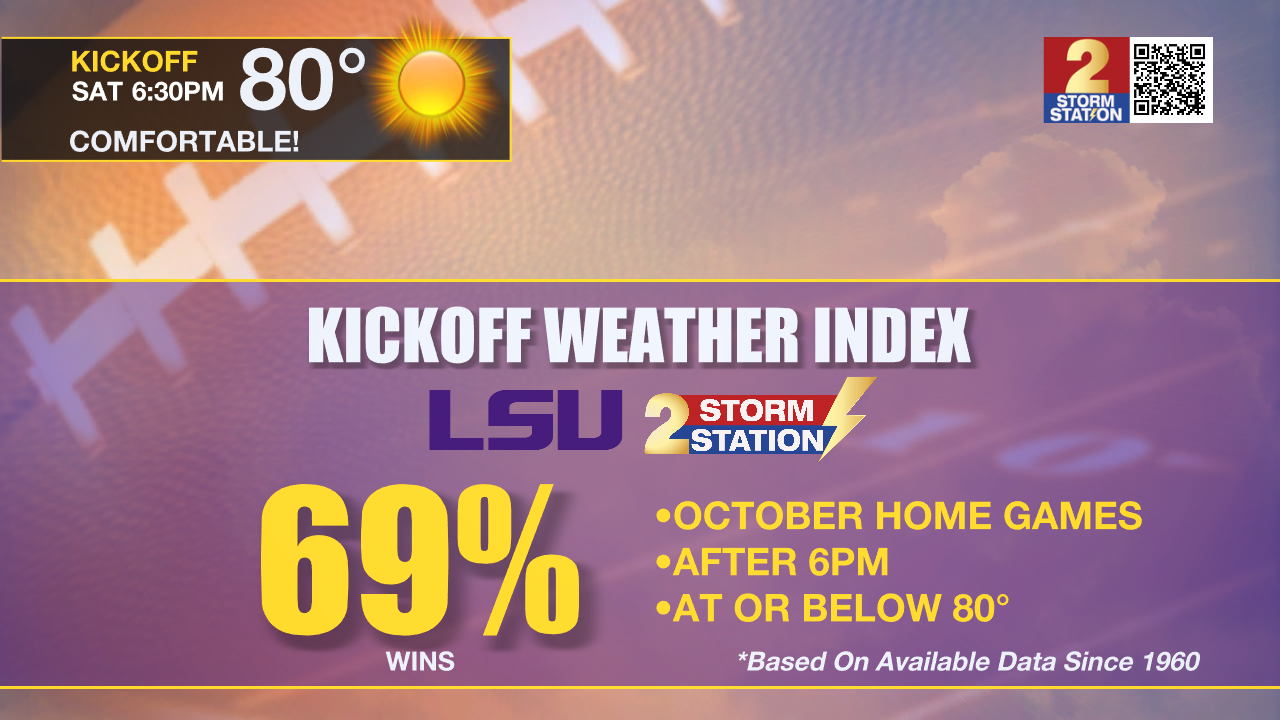
Saturday & LSU Football: You may want a light jacket for tailgating on Saturday morning. However, extra layers will be lost for short sleeves and shorts as sunshine pushes temperatures into the 80s during the afternoon. As LSU takes on Ole Miss at 6:30pm in Tiger Stadium, temperatures will be in the upper 70s. The LSU Kickoff Weather Index shows the Tigers winning 69% of October home games after 6pm when temperatures are below 80 degrees.
Up Next: A slight rebound in warmth and mugginess is expected Sunday and Monday with low temperatures in the mid 60s and high temperatures in the low 90s. Still, mostly clear skies will prevail though a few clouds are not out of the question. An even stronger fall front will push through the area Monday night into Tuesday which will bring temperatures cool enough to keep highs in the 70s and lows in the low 50s! As usual, areas north of Baton Rouge will be a little bit cooler and could reach the 40s for the first time this season.
Get the latest 7-day forecast and real time weather updates HERE.
Watch live news HERE.
The Tropics: Milton has become a hurricane force extratropical low as it pulls away from the United States. Milton is racing to the east at 20-25mph and will gradually weaken.

Hurricane Leslie is showing the first signs of weakening over the open, Atlantic Ocean. Moving northwest at 5-10mph, the storm will turn north and then northeast rapidly weakening into the weekend.
A tropical wave over the far eastern tropical Atlantic continues to produce disorganized showers and thunderstorms. Environmental conditions appear marginal for limited development of this system while it moves westward or west-northwestward across the eastern tropical Atlantic and the Cabo Verde Islands on Friday. By Saturday, upper-level winds are forecast to become less favorable, and further development is unlikely after that time. Regardless of development, localized areas of heavy rain are possible across portions of the Cabo Verde Islands tonight through Friday.
The Storm Station is here for you, on every platform. Your weather updates can be found on News 2, wbrz.com, and the WBRZ WX App on your Apple or Android device. Follow WBRZ Weather on Facebook and Twitter for even more weather updates while you are on the go.
More News
