

Latest Weather Blog
Thursday PM Forecast: heat index to climb well over 100 through Sunday
The remnants of Alberto will rain out over Mexico while winds and coastal flooding relax over the Capital Area. Hot and steamy conditions will take hold for the weekend.
Tonight & Tomorrow: Beyond nightfall, showers and thunderstorms will diminish. Expect mostly clear skies with low temperatures in the mid 70s. The workweek will end quieter than it began. Full sunshine to start will give way to some clouds bubbling up due to high temperatures reaching the mid 90s. Additionally, one or two showers may develop, especially south of I-10. It will stay hot all day where a shower does not occur and the humidity will make it feel even more uncomfortable.
Up Next: An upper level ridge of high pressure, we call it “the heat dome”, will dominate over the weekend. This feature will dramatically reduce the possibility of showers and thunderstorms while also increasing temperatures. Both Saturday and Sunday will be very hot and rather humid. Look for low temperatures in the mid 70s and high temperatures in the upper 90s. The humidity will cause feels like temperatures over 105 degrees. Keep in mind that at 107 degrees, heat advisories become necessary. Alert or not, it would be a good idea to remain hydrated and take it easy outdoors during the peak heating hours of the afternoon. The ridge will slowly break down early next week and by Tuesday, coverage in showers and thunderstorms will increase again, cutting into the duration of the heat each day.
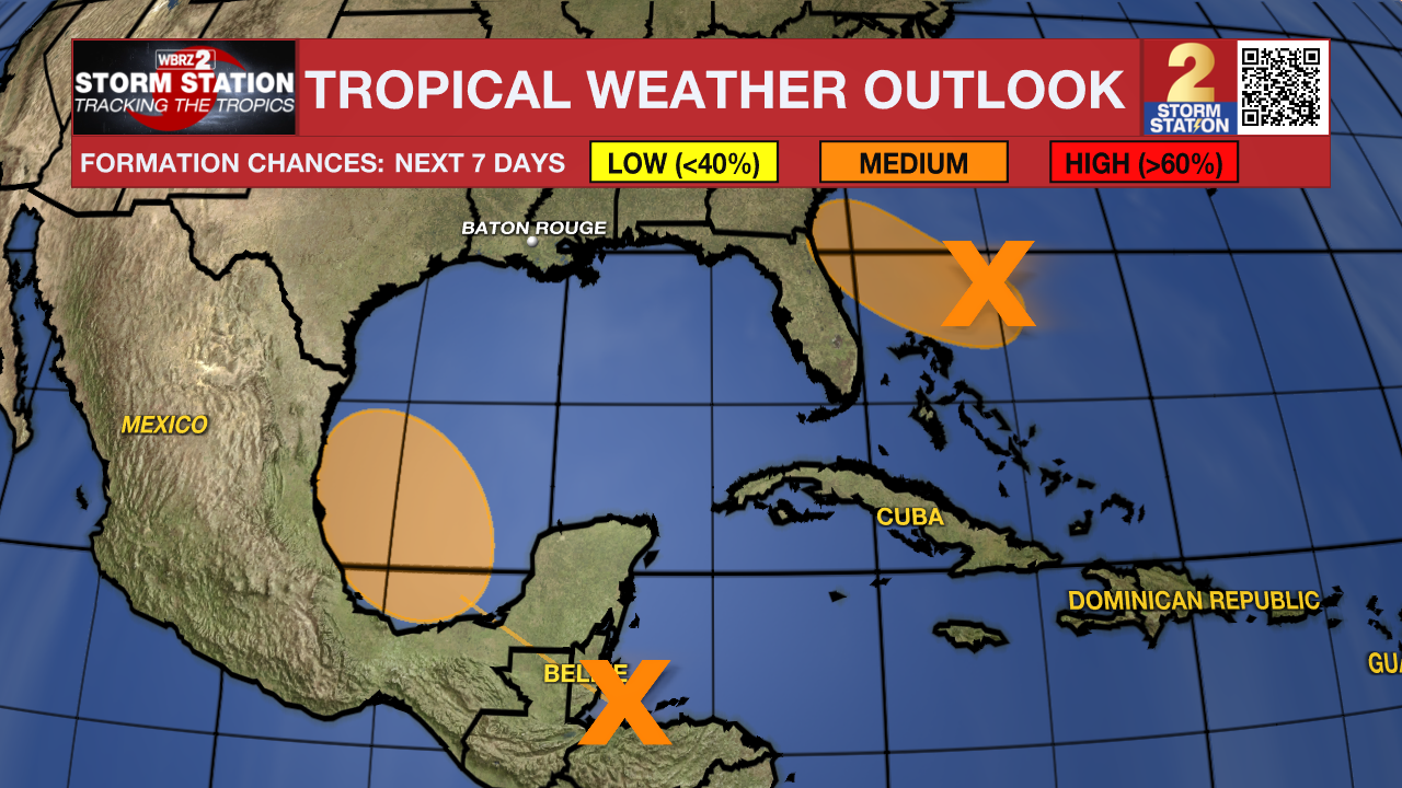
The Tropics: Tropical Storm Alberto has diminished over central Mexico. While the National Hurricane Center has issued the final advisory, heavy rain, flash flooding and mudslides may continue across central and northeastern Mexico.
Trending News
Data from an Air Force Reserve reconnaissance aircraft indicates that the small area of low pressure located about 150 miles northeast of the northernmost Bahamas does not have a well-defined surface circulation. Environmental conditions remain marginally conducive for further development and this system could become a tropical depression while the low moves west-northwestward at 10 to 15 mph. The system is expected to approach the northeastern coast of Florida or the Georgia coast early on Friday.
A broad area of low pressure is forecast to form over southeastern Mexico and northern Central America on Friday. Environmental conditions appear conducive for gradual development after this system moves over the Bay of Campeche on Saturday, and a tropical depression could form over the southwestern Gulf of Mexico this weekend while it moves slowly west-northwestward or northwestward.
Get the latest 7-day forecast and real time weather updates HERE.
Watch live news HERE.
– Josh
The Storm Station is here for you, on every platform. Your weather updates can be found on News 2, wbrz.com, and the WBRZ WX App on your Apple or Android device. Follow WBRZ Weather on Facebook and Twitter for even more weather updates while you are on the go.
More News
