

Latest Weather Blog
Thursday PM Forecast: Francine's final influence on local weather pulling away
As Francine pulls away from the Capital Area, local weather will settle into a quiet but seasonably warm pattern. Rain chances stay very low through the Storm Station 7-Day Forecast.
Tonight & Tomorrow: The stubborn cloud deck on the trailing side of Francine will slowly pull north overnight. Low temperatures will dip to 69 degrees which is near average for this time of year. Friday will bring mostly sunny skies with little more than some fair-weather cumulus clouds. High temperatures will top out at 89 degrees.
Up Next: The upcoming weekend will be cooperative for ongoing recovery after the storm as well as any outdoor activities. Saturday may feature a little more sunshine than Sunday but both days will be quiet with just a spotty shower possible before the end of the weekend. Look for high temperatures in the low 90s and low temperatures in the upper 60s. By early next week, the atmosphere may become just unstable enough to support isolated showers, but these would be the exception rather than the rule. The best, but still small, chance will be on Monday and Tuesday. There will not be any major change in temperatures next week.
Get the latest 7-day forecast and real time weather updates HERE.
Watch live news HERE.
Trending News
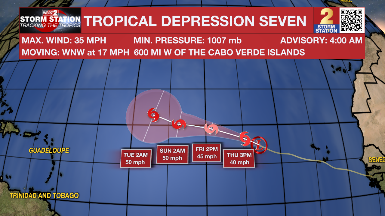
The Tropics: Tropical Depression Seven has formed in the far western Atlantic Ocean and is moving west-northwest over open waters at 16mph. With maximum sustained winds of 35mph, the storm is expected to be named Gordon with some strengthening over the coming days. As of now, it poses no threat to land.
Showers and thunderstorms continue to show signs of organization in association with a small area of low pressure located a few hundred miles east of the Leeward Islands. However, the proximity of dry air near the system could limit additional development over the next couple of days. Environmental conditions are expected to become even less conducive over the weekend while the system moves slowly west northwestward. Regardless of development, this system could produce locally heavy rainfall and gusty winds across the northern Leeward Islands on Friday.
A non-tropical area of low pressure could form along a residual frontal boundary a few hundred miles off the southeastern U.S. coastline this weekend. Thereafter, some subtropical or tropical development is possible during the early part of next week while the system drifts to the north or northwest.
– Josh
The Storm Station is here for you, on every platform. Your weather updates can be found on News 2, wbrz.com, and the WBRZ WX App on your Apple or Android device. Follow WBRZ Weather on Facebook and Twitter for even more weather updates while you are on the go.
More News
