

Latest Weather Blog
Thursday PM Forecast: comfortable conditions in control through weekend
Hurricane Helene made an official landfall during at 10:10pm CT Thursday night near just east of the mouth of the Aucilla River. At that time, areas near the eye wall were under an EXTREME WIND WARNING as the storm packed maximum sustained winds of 140mph. This rarely used alert is issued when catastrophic wind damage, equivalent to that of a strong tornado, will affect a vast area.
A cold front sits well south and east of the Capital Area. Much drier and slightly cooler conditions will prevail as the workweek ends. Hurricane Helene will strike the Big Bend Region of Florida overnight.
Tonight & Tomorrow: With the well advertised cold front now into the Gulf of Mexico, humidity has dropped considerably and temperatures have fallen noticeably. Lows will go into the low 60s across Metro Baton Rouge, the coolest readings since early May. Some locations north and east of Baton Rouge could dip into the upper 50s. Friday will feature an afternoon of sunshine and seasonably mild temperatures in the mid to upper 80s. A gorgeous evening is ahead for high school football as thermometers fall out of the 80s and into the 70s.
Trending News
LSU Football: According to the Storm Station LSU Football Kickoff Weather Index, the Tigers have an 85% success rate in these conditions. Kickoff at 6:30pm is slated for a temperature in the upper 70s with mostly sunny skies. Review the index through the season and see the last time the team lost in this weather, HERE.
Up Next: The weekend will be mostly sunny and seasonable with highs in the mid to upper 80s and low humidity. A string of pleasant mornings is also expected with lows in the mid 60s. Rain will be hard to find through the remainder of the forecast with temperatures only gradually working back above average by the middle of next week. A weak, reinforcing front will push through on Wednesday and keep humidity from returning to that summery steaminess.
Get the latest 7-day forecast and real time weather updates HERE.
Watch live news HERE.

The Tropics: Hurricane Helene has become a major storm with maximum sustained winds of 140mph. Moving to the northeast at 24mph, it is expected to make landfall in the Florida Big Bend Thursday night. The fast forward speed will allow the system to retain hurricane force winds, possibly as far inland as Atlanta, Georgia. Remnants will slow down across Tennessee on Friday. After a surge of 10-15 feet near the landfall location, damaging winds and flooding rain will spread all across much of Florida, Georgia, and higher elevations of The Carolinas.
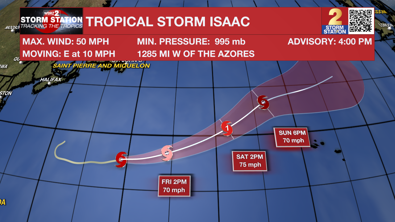
Tropical Storm Isaac is cross the north, central Atlantic Ocean with maximum sustained winds of 50mph. Though it may reach hurricane strength Friday or Saturday, this storm will not be near any landmasses.
Showers and thunderstorms associated with an area of low pressure located several hundred miles west of the Cabo Verde Islands continue to show signs of organization. Recent satellite imagery suggests the system does not yet have a well-defined surface circulation. However, environmental conditions are expected to be conducive for further development. A tropical depression is expected to form later today or tomorrow while the disturbance moves generally westward to west northwestward at 10 to 15 mph. The system is then forecast to slow down and turn northward late Friday and Saturday.
An area of low pressure could form over the western Caribbean by the middle of next week. Environmental conditions are expected to be conducive for slow development thereafter, while the system moves generally northwestward.
– Josh
The Storm Station is here for you, on every platform. Your weather updates can be found on News 2, wbrz.com, and the WBRZ WX App on your Apple or Android device. Follow WBRZ Weather on Facebook and Twitter for even more weather updates while you are on the go.
More News
