

Latest Weather Blog
Thursday PM Forecast: after near record warmth, tropical moisture increases rain chances
The two big stories to watch in weather will be the near record warmth to end the workweek and the potential for tropical moisture to increase rain coverage. If you have outdoor plans over the weekend, stay in touch with the forecast.
Tonight & Tomorrow: Mostly clear skies will continue through the overnight hours as low temperatures hover near average in the low 70s. An even hotter afternoon is expected on Friday with high temperatures in the mid 90s. Expect ample sunshine with only a few fair weather cumulus clouds developing in response to daytime warming.
Up Next: Thermometers could reach their highest levels so far this year. 98 was achieved on Memorial Day and also June 8. However, the current forecast high for Saturday is 99. That is unusually warm, and it is worth noting that despite 32 days above the century mark in 2023, the Baton Rouge Area has only hit 100 in 29% of years since 1892. With the hot temperatures, humidity will be somewhat in check but just enough will be present to push feels like temperatures in the 103 – 108 degrees range. Humidity and moisture will increase more dramatically Saturday night into Sunday. With this, after highs achieve the low 90s, scattered showers and thunderstorms are expected to develop signaling the beginning of a more active weather pattern. If you have outdoor plans on Father’s Day, plan for some occasional indoor adjustments, but a washout is not anticipated.
Each day through the middle of the week will carry the possibility of scattered showers and thunderstorms, some of which could bring downpours. There is not a major concern for flooding, but summer thunderstorm are always capable of creating isolated pockets of poor drainage flooding. The wetter pattern will keep temperatures slightly below average.
Trending News
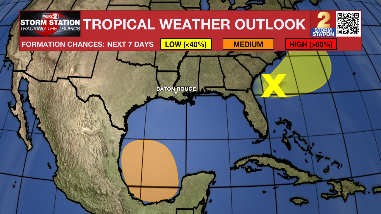
The Tropics: An elongated area of low pressure offshore the southeastern U.S coast is producing a large area of disorganized showers and thunderstorms. Despite strong upper-level winds, some gradual development is possible while the system moves northeastward offshore of the southeastern U.S. coast during the next day or so. Regardless of development, heavy rainfall is forecast to continue across portions of the Florida peninsula through late this week. For more information, see products issued by the Weather Prediction Center and local National Weather Service Forecast Offices.
A broad area of low pressure is forecast to form over the southwestern Gulf of Mexico late this weekend or early next week. Environmental conditions appear conducive for gradual development of this system, and a tropical depression could form during the early or middle part of next week while it moves slowly westward or west-northwestward. That system is not expected to affect the local area with the exception of providing increased moisture for showers and thunderstorms.
Get the latest 7-day forecast and real time weather updates HERE.
Watch live news HERE.
– Josh
The Storm Station is here for you, on every platform. Your weather updates can be found on News 2, wbrz.com, and the WBRZ WX App on your Apple or Android device. Follow WBRZ Weather on Facebook and Twitter for even more weather updates while you are on the go.
More News
