

Latest Weather Blog
Thursday AM Forecast: Streak of hot days continues into August; monitoring the tropics
A *HEAT ADVISORY* is in effect from 10am to 7pm Thursday as feels-like temperatures up to 112 degrees are expected across the entire Storm Station Forecast Area. Hot temperatures and high humidity may cause heat illnesses. Drink plenty of fluids, and when possible, stay in an air-conditioned rooms, avoid afternoon sun, and check up on relatives and neighbors.
Today & Tonight: Thursday will be another very hot and mainly dry day across southeast Louisiana. Morning temperatures before sunrise will begin close to 80 degrees, quickly warming up once the sun dominates the sky by mid-morning. Afternoon high's will return to the upper-90's in the Capital Area, with heat index values in the 108 - 112 range during peak heating this afternoon. Besides one or two showers this afternoon, Thursday will feature ample amounts of sunshine with cumulus clouds around this afternoon. Expect another warm night, as temperatures will only fall near 80° by early Friday morning.
Up Next: More heat alerts will likely be issued in the coming days as Friday will be mainly sunny and dry with an afternoon high near 98°. The first weekend of August will be just as one would expect in southern Louisiana; hot, humid, and with afternoon pop-up storms. As a weak front pushes extra moisture in from the north, Saturday holds the best chance of running into a shower or storm. Isolated or 40% coverage is expected on Saturday, though when not raining, conditions will be partly sunny and very hot. Sunday also holds a chance for isolated pop-up showers with afternoon highs each day in the middle 90's. The hot, summertime pattern will likely then continue into the first full week of the month.
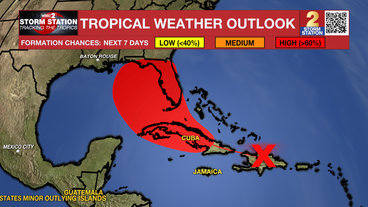
The Tropics: A tropical wave located over Hispañola is becoming more well-defined. Development of this system will be slow to occur in the next day or so while it continues to move over the Greater Antilles. However conditions will become more favorable for development after it emerges over open water again. Based on the latest data, a track into the eastern Gulf looks increasingly possible. A tropical depression is likely to form this weekend or early next week over the eastern Gulf of Mexico. Please remember that until the system gets better organized, forecast guidance is prone to big changes and has high uncertainty. There is time to monitor trends. Stay in touch with the Storm Station as we closely monitor the system.
Trending News
Get the latest 7-day forecast and real time weather updates HERE.
Watch live news HERE.
– Emma Kate C., Malcolm Byron
The Storm Station is here for you, on every platform. Your weather updates can be found on News 2, wbrz.com, and the WBRZ WX App on your Apple or Android device. Follow WBRZ Weather on Facebook and Twitter for even more weather updates while you are on the go.
More News
