

Latest Weather Blog
Thursday AM Forecast: Monitoring fire risk, frost potential, & tracking next rainmaker
A cooler and dry end to the workweek raises concerns for fire weather and frosty conditions. By the weekend, temperatures warm and moisture returns ahead of the next rainmaker.
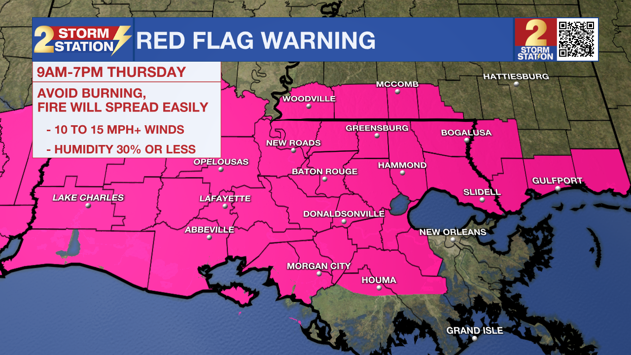
A RED FLAG WARNING is in effect Thursday from 9 AM to 7 PM for southeast Louisiana and southern Mississippi. Strong winds of 15-25 mph with gusts up to 30 mph and low humidity, as low as 20%, will create dangerous fire conditions. Fires can start and spread quickly. Avoid outdoor burning—it’s not safe! Be extra cautious with anything that could spark a fire. Stay alert and help prevent wildfires!
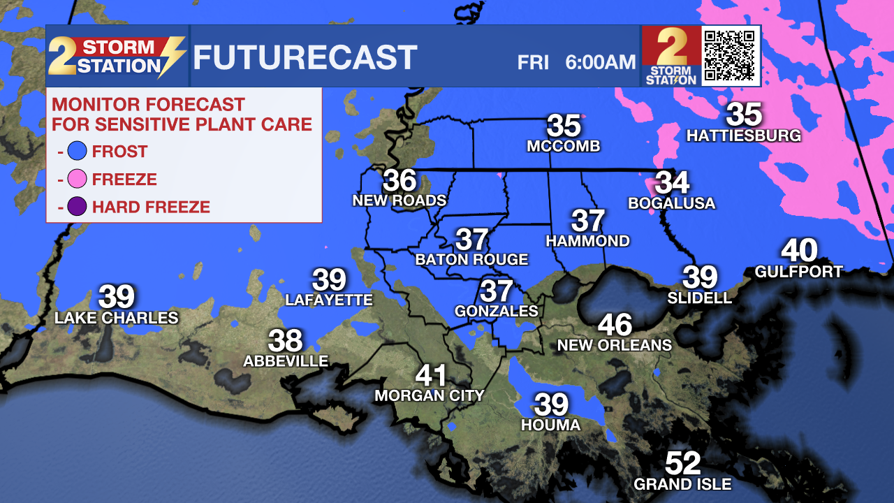
Today & Tonight: Behind a cold front passage late Wednesday night, cooler and drier air quickly moved in thanks to northwest winds blowing at 10-15 mph. Chilly morning temperatures in the 40s will slowly warm throughout the day. Look for a high temperature in the middle-60s under sunny skies Thursday afternoon. Winds remain breezy all day with gusts in the 30mph range at times. Overnight, calmer winds and clear skies will allow overnight temperatures to tumble. Middle to upper-30s are expected Friday morning which could allow for areas of frost, especially along and north of I-10/12. Those with tropical plants and/or new blooms may want to take precautions by protecting the sensitive plants.
Up Next: Frost will not be an issue over the weekend as temperatures warm back up. Friday will start off in the upper-40s before climbing into the low 70s under full sunshine. Saturday will also be sunny and dry with highs near 80 degrees.
Sunday into Monday: The next rainmaker is set to arrive by the end of the weekend. While the majority of Sunday looks to be dry as clouds begin to increase, a few isolated showers and storms may arrive Sunday afternoon. A more significant batch of rain will arrive late Sunday night into Monday morning as a cold front pushes through the region. Keep an eye on Monday morning's commute as rain could make it a messy one.
Trending News
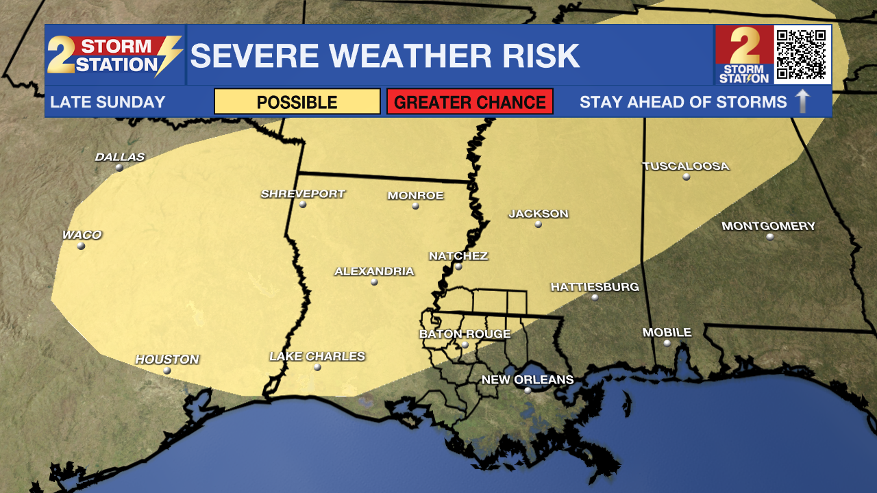
While the severe weather threat remains low for most of southeast Louisiana at this time, a few storms may be on the stronger side as the system passes through. There appears to be an overlap in severe weather ingredients on Sunday in northern Louisiana, and that is where the Storm Prediction Center highlights a risk of severe weather. A minor shift in the forecast could result in some changes to this, so stay in touch with the Storm Station as the weekend draws near.
Get the latest 7-day forecast and real-time weather updates HERE.
Watch live news HERE.
- Emma Kate C.
The Storm Station is here for you, on every platform. Your weather updates can be found on News 2, wbrz.com, and the WBRZ WX App on your Apple or Android device. Follow WBRZ Weather on Facebook and X for even more weather updates while you are on the go.
More News
