

Latest Weather Blog
Thursday AM Forecast: Mid-October chill continues
Cold mornings and mild afternoons will finish off the workweek. A slight warm up is to be expected over the weekend.
Today & Tonight: Clear skies, extremely dry air, and light winds will allow temperatures to drop the lowest they've been in months early Thursday. Wake-up temperatures across the Capital Area will be in the low to mid 40's, with cities near the state line possibly seeing the upper-30s before sunrise. Jackets will be needed for kids standing by the bus stop or any early morning activities. By lunchtime, temperatures will have slowly warmed into the upper 60s under full sunshine. Afternoon highs today will be in the middle 70's. Because winds have calmed out, the fire threat is not as high today; however, conditions remain very dry and it is still advised to be very cautious and limit outdoor fire use when possible.
Overnight, clear skies will continue as temperatures cool back into the 40s for another chilly start on Friday.
Up Next: Friday will be another cool and dry day with sunny skies featuring a few high clouds. Afternoon temperatures will be in the mid to upper 70s around the region, still a few degrees below average for the middle of October. The quiet conditions will continue into the weekend with slight warming each day. Expect cool mornings in the 50s and afternoons in the low 80s with plenty of sunshine and low humidity. Similar conditions will trickle into the next workweek. Still, no rain is in the forecast.
Football Forecasts: The Friday Night Blitz is looking like a picture perfect fall football evening. With mostly clear skies, temperatures will settle into the 60s during the games. Take a layer to add. On The Bluff, Southern Homecoming couldn’t ask for much better weather. Some light layers may be wanted during the morning and evening but tailgating and afternoon festivities will have sun and temperatures in the low 80s. LSU fans hitting the road can expect clear and chilly conditions in Fayetteville. Temperatures will move from the mid 40s around dawn to mid 70s in the afternoon and retreat into the 60s and 50s during the game.
Trending News
Get the latest 7-day forecast and real time weather updates HERE.
Watch live news HERE.
The Tropics: Showers and thunderstorms associated with a trough of low pressure located several hundred miles east of the Leeward Islands remain disorganized. Environmental conditions appear only marginally conducive for slow development as the disturbance moves quickly westward to west-northwestward around 20 mph, passing near the Virgin Islands and Puerto Rico on Friday, then near the Greater Antilles over the weekend.
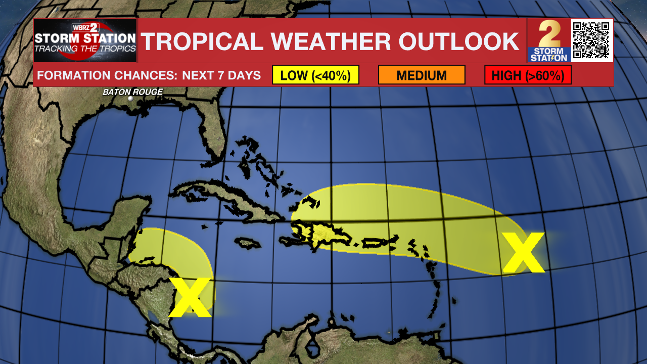
Showers and thunderstorms over the southwestern Caribbean Sea are associated with a broad area of low pressure. Some gradual development is possible over the next couple of days if the system stays over water while it moves slowly northwestward toward Central America. Regardless of development, locally heavy rainfall is possible across portions of Central America and southern Mexico late this week and into the weekend.
– Emma Kate C.
The Storm Station is here for you, on every platform. Your weather updates can be found on News 2, wbrz.com, and the WBRZ WX App on your Apple or Android device. Follow WBRZ Weather on Facebook and Twitter for even more weather updates while you are on the go.
More News
