

Latest Weather Blog
Thursday AM Forecast: Daily rain chances return, Tropical development odds lessen in Gulf
A shift in weather pattern begins today as moisture returns to the area. An increase in cloud cover will be the biggest change with a few showers and storms around as well.
Today & Tonight: Clear skies and cool temperatures will kick off your Thursday. Lows will dip down into the middle 60's right around sunrise, which will be after 7:00am beginning today through the end of Daylight Saving Time in early November! Throughout the day, easterly winds will help aid in the return of gulf moisture into the region. As this happens, clouds will increase and a few spotty showers will develop, especially in coastal areas. The Capital City and areas north will likely remain dry today and see temperatures near 90 degrees this afternoon. Skies will remain partly cloudy into the overnight hours, limited temperatures to the low-70's Friday morning.
Up Next: Friday and Saturday will see mostly cloudy skies and the best chance for rain of the week. With an uptick in moisture in the air, isolated showers will develop each afternoon around southeast Louisiana. Only 30-40% of WBRZ's 13 parish and 2 county coverage area will see rain each day, meaning the majority will remain dry. No washout either day is expected but mostly cloudy skies may make outdoor activities a bit gloomy while keeping temperatures in the upper-80's each afternoon. With rain tapering during the evening, the weather will become more cooperative for high school football on Friday night and Southern's game versus Nicholls State on Saturday night.
Rain chances decline again on Sunday and Monday as a cold front approaches from the northeast. The front will bring cooler and drier air back to Louisiana, giving us another taste of fall!
Get the latest 7-day forecast and real time weather updates HERE.
Trending News
Watch live news HERE.
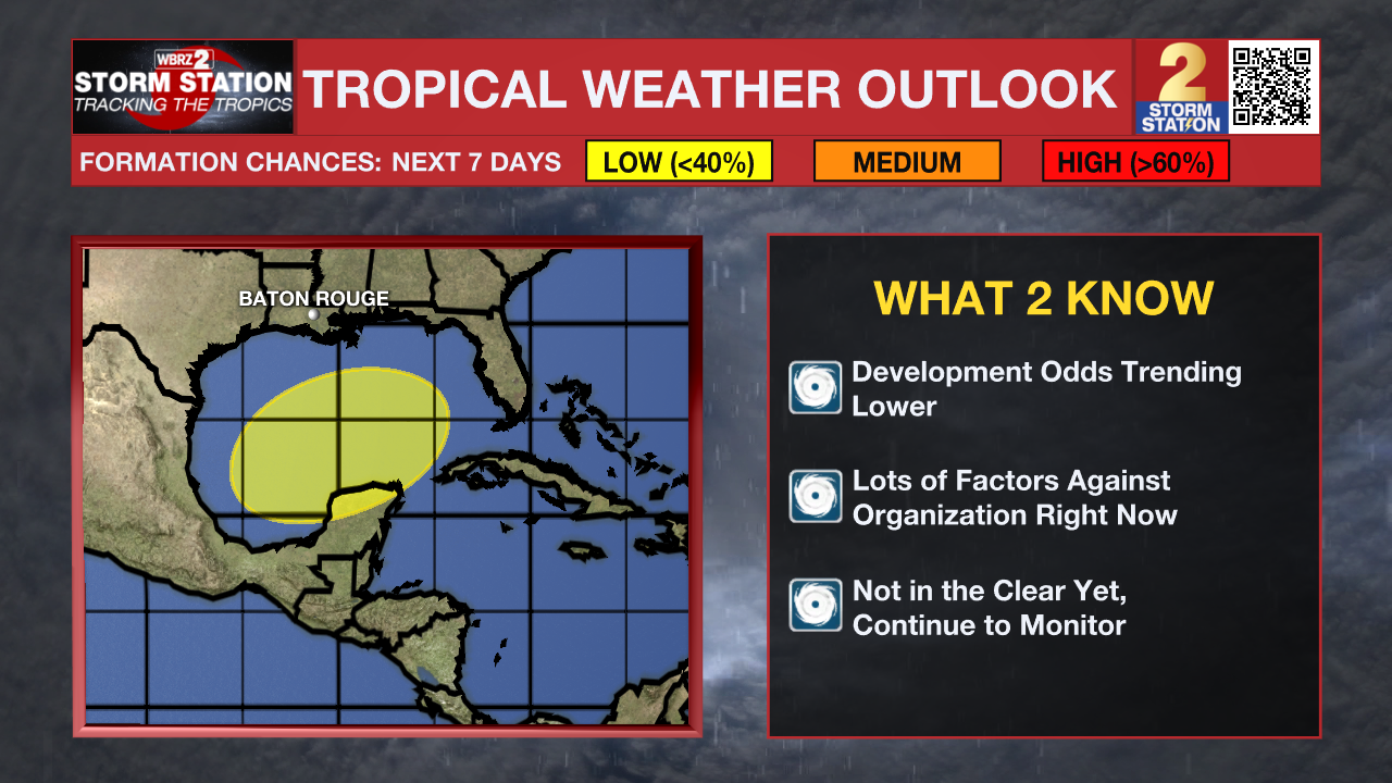
The Tropics: Early Thursday morning, the National Hurricane Center downgraded the area in the Gulf of Mexico to having a low (30%) chance of tropical development over the next week. Gradual development may still be possible in the coming days, but recent data does show there are many factors working against this system in the atmosphere. Check back in with the Storm Station throughout the weekend as we continue to monitor this region. At this time, tropical impacts in Louisiana are unlikely in the next seven days.
Hurricane Kirk continues to strengthen as it moves across the central Atlantic Ocean. The storm will rapidly intensify in the coming days, potentially becoming a Category 4 hurricane by Friday. Fortunately, Kirk will stay out to sea posing no threat to land.
Tropical Storm Leslie continues to strengthen east of Kirk Thursday morning. This system will likely become a hurricane over the weekend while continuing to trail behind Kirk and will track in a similar fashion. As a result, this system will also pose no threat to land.
- Emma Kate C.
The Storm Station is here for you, on every platform. Your weather updates can be found on News 2, wbrz.com, and the WBRZ WX App on your Apple or Android device. Follow WBRZ Weather on Facebook and Twitter for even more weather updates while you are on the go.
More News
