Sunday PM Forecast: Tracking a cool front, plus a disturbance soon to enter Gulf of Mexico
The summer steam remains for a few more days. However, a cold front passage could bring some changes by midweek. This same front will also play an important role with regard to some tropical mischief in the Gulf of Mexico.
Tonight & Tomorrow: Afternoon clouds will fizzle out on Sunday night, leaving behind a mainly clear skies. A few patches of early morning fog are not out of the question for areas low in elevation and close to water, but it should not be a widespread issue. Monday marks the first full day of fall, but it will hardly feel fall-like. Highs will be in the mid-90s in Baton Rouge with peak feels-like temperatures close to 100°. A very select few might come across a stray shower. But most will stay dry under mostly sunny skies.
Up Next: Expect nothing more than a continuation of heat and humidity on Tuesday. However, a cold front will be approaching from the northwest. As the front arrives on Wednesday, it will stimulate the development of isolated showers and thunderstorms. The latest data seem to indicate a frontal passage by Thursday. This would leave the region with a reduction in temperatures, dip in humidity, and lack of rain chances late this week and into the weekend. That said, this is still a couple of days and there's still some time for things to shift around.
The cold front will also play an important role with the tropical mischief entering the Gulf of Mexico this week. The next named tropical storm, perhaps hurricane, will be moving north toward the Gulf Coast by late week (see The Tropics section). Those that benefit from the passage of said front will also be effectively shielded from major tropical impacts. But areas east of the front could end up seeing impacts from an organized tropical system. Should new data indicate that Louisiana does not see a clean cold front passage, potential tropical impacts could come into play by late week. For that reason, it will be important to stay up to date with the latest Storm Station this week.
Get the latest 7-day forecast and real time weather updates HERE.
Trending News
Watch live news HERE.
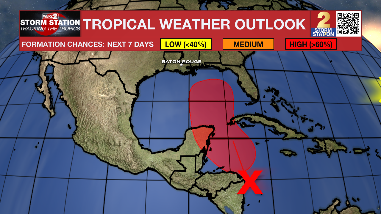
The Tropics: A disorganized region of showers and thunderstorms is located over the northwest Caribbean Sea and portions of Central America. Conditions will become more favorable for tropical development in the coming days. A tropical depression or tropical storm is likely to form by midweek as the system moves through the northwestern Caribbean Sea and into the Gulf of Mexico. The next name up is Helene.
The steering currents for this system will push it toward the central and eastern Gulf Coasts by late week. There are still a lot of unknowns with regard to the long-term track since the system has yet to develop. Once a well-defined center of circulation consolidates, more details will come to light. Additionally, a cold front sweeping through the southern United States will act as an "invisible wall" preventing the storm from passing through it. Placement of this front will be key also.
Should said cold front pass through Louisiana, tropical impacts would be confined to the east. If not, a Louisiana landfall would still be on the table.

A tropical wave located near the west coast of Africa is expected to move westward during the next several days. Gradual development of this this system is possible by mid to late week as it moves through the tropical Atlantic. This system does not appear to bring any impacts to Louisiana in the long-term.
-- Meteorologist Malcolm Byron
The Storm Station is here for you, on every platform. Your weather updates can be found on News 2, wbrz.com, and the WBRZ WX App on your Apple or Android device. Follow WBRZ Weather on Facebook and Twitter for even more weather updates while you are on the go.


