

Latest Weather Blog
Sunday PM Forecast: Soggy weather carries over into the workweek
The stream of tropical moisture has arrived, elevating rain chances into the workweek. Umbrellas will be our friend for a few days.
Tonight & Tomorrow: After a soggy Father's Day, rain coverage will diminish into the evening. Although a hit-or-miss shower is not out of the question, much of Sunday night will be dry under mostly cloudy skies. Look for an overnight low near 75° in Baton Rouge. However, we're not off the hook yet when it comes to rain. Storm chances ramp right back up starting Monday morning. While it will not be raining at every point for any one spot, the area will be dodging these storms from start to finish. The presence of rain will keep temperatures on the cooler side. Highs will be stuck in the 80s.
Monday will be a day to keep the rain gear close by, and be prepared to face slower commutes both in the morning and evening as a precaution. Some lingering showers will be possible even on Monday night.
Up Next: The steady stream of tropical moisture hangs around on Tuesday also. While rain coverage may end up a tad lower as compared to Monday, scattered storms do appear to stick around. Some drier air will nudge into the area by midweek, helping to usher the tropical moisture westward. This will lower rain chances and allow highs to climb back into the 90s. Even with a lower rain chance by midweek, the typical summertime pattern with pop-up afternoon storms will remain firmly in place. This pattern will carry over into the weekend also, with minor day-to-day variations hinging on how much tropical moisture is present.
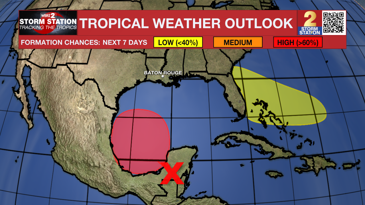
The Tropics: A large area of storms located over the Yucatan Peninsula will move over the southwestern Gulf of Mexico into next week. Conditions appear favorable for gradual development of this system. There is a high chance of tropical depression or storm formation by midweek. If the system were to reach tropical storm status (sustained winds 39+ mph), it would take the name Alberto.
The Storm Station believes that this system will remain well to the southwest of Louisiana. However, areas in northern Mexico and southern Texas should monitor the progress of the storm closely. Should the disturbance acquire tropical characteristics, find out first via the Storm Station mobile app.
Trending News
Another area of low pressure is expected to form by midweek a few hundred miles northeast of the Bahamas. Conditions appear conducive for some development of the system as it drifts west, but overall odds appear low per the latest data. This disturbance would track west through Florida and hug the Gulf Coast. This is nothing to be concerned about as of now, but the Storm Station will keep a close eye on the system.
Get the latest 7-day forecast and real time weather updates HERE.
Watch live news HERE.
-- Meteorologist Malcolm Byron
The Storm Station is here for you, on every platform. Your weather updates can be found on News 2, wbrz.com, and the WBRZ WX App on your Apple or Android device. Follow WBRZ Weather on Facebook and Twitter for even more weather updates while you are on the go.
More News
