

Latest Weather Blog
Sunday PM Forecast: Back to the full summer steam, tracking soon-to-be Ernesto
Although a few periods brought lesser humidity in recent days, the capital area will see a return to the full steam next week. The Storm Station is also tracking a new area of concern in the tropics.
Tonight & Tomorrow: Mostly clear skies on Sunday night will allow for optimal viewing of the Perseid meteor shower. City lights can make it more difficult to spot meteors, so try to find a darker location. The best viewing time will be after midnight. Humidity will nudge upward overnight, so the air will not be as comfortable for the Monday morning drive. Temperatures will also increase - look for an morning low near 77° in Baton Rouge.
Humidity continues to creep back into the capital area on Monday. That, coupled with a high in the upper-90s will result in triple-digit feels-like temperatures. However, peak heat index values may end up slightly below Heat Advisory criteria (108°) for much of the capital area. The same heat common-sense applies advisory or not, so keep up with the hydration. Rain-cooling showers will be few and far between, although a few hit-or-miss storms are not out of the question in the afternoon.
The heat could also lead to increased ozone formation in the afternoon. For that reason, an Air Quality Alert has been issued for Monday. Those specifically with breathing sensitivities may want to limit their time outside.
Up Next: The full steam will be back by Tuesday, and more heat alerts are likely. There isn't too much day-to-day variation in the forecast for the workweek. Just about every day will feature lows in the upper-70s, highs in the upper-90s, loads of humidity, and a small shot a stray afternoon shower. With lots of heat and relatively dry conditions, you'll want to keep your lawns watered. Most grass varieties in south Louisiana generally require 1-2" of water per week to keep a nice green color.
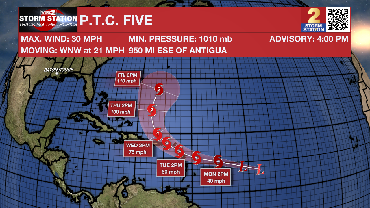
The Tropics: The National Hurricane Center has begun issuing advisories on Potential Tropical Cyclone (P.T.C.) Five, located a little less than 1000 miles east of the Lesser Antilles. The "potential tropical cyclone" terminology is used when a disturbance has yet to acquire tropical characteristics, but will likely do so within 48 hours and impact land. Several Tropical Storm Watches have been issued for parts of the Leeward Islands.
Trending News
P.T.C. Five will likely become a tropical storm early this week, taking the name Ernesto once that happens. A landfall somewhere in the Leeward Island chain and possibly Puerto Rico could occur by midweek as the storm intensifies to near-hurricane strength. Afterward, most data suggest a recurve scenario toward the general direction of Bermuda. The Storm Station does not anticipate any impacts in Louisiana at this time.
Get the latest 7-day forecast and real time weather updates HERE.
Watch live news HERE.
-- Meteorologist Malcolm Byron
The Storm Station is here for you, on every platform. Your weather updates can be found on News 2, wbrz.com, and the WBRZ WX App on your Apple or Android device. Follow WBRZ Weather on Facebook and Twitter for even more weather updates while you are on the go.
More News
